Nahne
|
|||
|---|---|---|---|
Map:
|
|||
| Basic data | |||
| Area : | 4.75 km² | ||
| Residents : | 2.229 As of December 31, 2018 | ||
| Population density : | 469 inhabitants / km² | ||
| Postal code : | 49082 | ||
| Primaries : | 0541 | ||
| structure | |||
| District number: |
23 |
||
Nahne is a district in the south of Osnabrück with 2229 inhabitants (12/2018), spread over an area of 4.75 km². Nahne is thus the district with the lowest number of inhabitants in Osnabrück.
Spatial structure
Nahne borders the Schölerberg district in the north, the Kalkhügel district in the northwest, the Sutthausen district in the west and the Voxtrup district in the east . In the south, the Harderberg district of the town of Georgsmarienhütte joins Nahne.
The Nahnes terrain is hilly: the district lies between the Schölerberg (127 m above sea level) and the Osterberg (173 m above sea level). Most of the area of Nahnes is agricultural area. The district is divided in a north-south direction by Iburger Strasse ( Bundesstrasse 51 , Bundesstrasse 68 ) and in an east-west direction by Bundesautobahn 30 . The two traffic axes are linked at their intersection by the Osnabrück-Nahne junction . The residential development is concentrated to the northwest and southeast of these traffic axes. The Am Wulfter Turm industrial park north of Sutthausen also belongs to Nahne.
history
The megalithic stone graves near Nahne are among the first human traces in the Nahn area . The Nahne farmers are around 850 years old and belonged to the parish of St. Johann in Osnabrück. Even before the incorporation, which took effect on July 1, 1972, Nahne was economically strongly tied to the city. This is due, among other things, to the agrarian character of the place, which previously supplied the city with agricultural goods. Until 1934, Nahne was considerably larger and in the north reached as far as the Fledder district. Today the district is characterized by housing estates and large hypermarkets, with the district building in the east and medium-sized handicrafts and commercial enterprises in the west up to the district boundary on Sutthauser Straße. The formerly independent municipality of Nahne did not have its own coat of arms.
Personalities
Between August and November 1920, the writer Erich Maria Remarque taught as a primary school teacher in Nahne.
Nahne is the birthplace of the German SPD politician and Rostock member of the Bundestag Christian Kleiminger . He attended the Franz Hecker primary school here from 1972 to 1976.
Facilities and sights
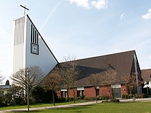
Facilities in the district are the Catholic St. Ansgar Church, the municipal Franz Hecker primary school , the Nahn cemetery and the sports facility of the TuS Nahne sports club . In addition, parts of the Osnabrück Zoo are located in the Nahn area.
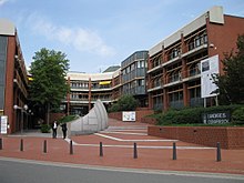
Nahne in the region Osnabrück is also known as the seat of the county house of the district of Osnabrück . Osnabrück is thus the capital of the district and namesake of a district to which it does not belong as an independent city. The district council - the highest body of the district - meets in the district building, and it is also the seat of the district administration.
Since the mid-1950s, motorcycle grass track races have been held on the Nahner Waldbahn . The events enjoy national interest, the organizer is the Auto- und Motorsportgemeinschaft (AMG) Osnabrück. Behind the district building is the original Expo 2000 project, Boden amusement park, of the TERRA.vita nature and geopark .
Web links
- Quarterly information from the Department of Urban Development and Citizen Participation, Statistics Division, 4/2008 (PDF file; 1.49 MB)
- City of Osnabrück, Department for Urban Development and Public Participation -Statistics-, 11/2009 (PDF file; 35.40 kB)
Individual evidence
- ↑ Municipal statistics and monitoring portal Osnabrück (KOSMOS): Population - residents with main residence , osnabrueck.de, accessed on August 3, 2019
- ↑ City of Osnabrück, statistics, size of the city districts and statistical districts 11/2011 (PDF file)
- ^ Federal Statistical Office (ed.): Historical municipality directory for the Federal Republic of Germany. Name, border and key number changes in municipalities, counties and administrative districts from May 27, 1970 to December 31, 1982 . W. Kohlhammer GmbH, Stuttgart / Mainz 1983, ISBN 3-17-003263-1 , p. 252 .
Coordinates: 52 ° 15 ' N , 8 ° 3' E


