Voxtrup
|
|||
|---|---|---|---|
Map:
|
|||
| Basic data | |||
| Area : | 10.91 km² | ||
| Residents : | 7,152 As of December 31, 2018 | ||
| Population density : | 656 inhabitants / km² | ||
| Postal code : | 49086 | ||
| Primaries : | 0541 | ||
| structure | |||
| District number: |
22nd |
||
Voxtrup is a district in the southeast of Osnabrück with 7152 inhabitants (12/2018) spread over an area of 10.91 km². In Voxtrup are the ev.-luth. Margaretenkirche and the cath. St. Anthony Church.
history
It can be assumed that there were already settlements in the Voxtrup area in prehistoric times. Most of the full legacy courts of farming communities Düstrup, Voxtrup and Hickingen can be said that they have long been present when the Saxon-Westphalia region at the end of the 8th century in the Frankish Empire was incorporated. Voxtrup was probably named after the Fokko clan. Originally three to five farms belonged to this clan: Arling, Hüdepohl, Werries, Brockmann and Strickmann.
Voxtrup has its starting point in the peasant communities Voxtrup, Molenseten, Düstrup and Hickingen. In a document from 1147, the four settlement centers of Voxtrup are named as one. Voxtrup, Düstrup and Hickingen are probably much older than their first documentary mentions.
Voxtrup was first mentioned in a document in 1088. However, the document is only available in a copy from the 14th century and contains a court certificate that the nobleman Eberhard had a farm in Bevern, which he wanted to hand over to Bishop Benno II for the benefit of the Iburg monastery in exchange for three pounds. after Benno's death transferred to his successor, Bishop Markwart, for the monastery. Vockestorp is named as the place of the court day. The court in loco Voccastorp (as stated in a document from 1090) was probably on the Mahlbrink in the area of the Gelshorn farm (today: Gut Waldhof).
On July 1, 1972, Voxtrup was incorporated into Osnabrück. The northernmost area of the district comes from the original district Schinkel, where the train station for the Osnabrück district Lüstringen was located on the Osnabrück - Hanover railway line until 1978.
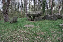
In the north of the district, north of the Hase , lies the Teufelssteine large stone grave . A few hundred meters to the east, the copper treasure of Osnabrück was found during construction work in 2016 , which is classified as archaeologically very important. It is an ax and three neck and breast jewelry ( lunulae ). Both the burial site and the copper treasure are believed to date from the Neolithic Age and are part of the funnel beaker culture.
Sports
The “VfR Voxtrup” has existed since 1927 and currently offers badminton, football, basketball, cycling, tennis, table tennis, gymnastics, volleyball, basketball and hiking.
Volunteer firefighter
The Osnabrück-Voxtrup volunteer fire brigade was founded back in 1938 and is now located on Holsten-Mündruper-Strasse in the heart of Voxtrup. Today the fleet consists of five modern emergency vehicles, three of which are large vehicles. In addition to "normal" fire fighting, the Voxtrup volunteer fire brigade also has the task of providing technical assistance in the event of traffic accidents. Together with comrades from Haste and Neustadt, she occupies the ELW 2 command vehicle and is part of the special water transport train and the technical assistance train (specializing in building collapses, rescuing buried people and special technical assistance). In addition to the operations department, there is also a youth fire brigade in Voxtrup , which celebrated its 25th anniversary in 2008. On August 21, 2010, the Voxtrup fire brigade launched the first children's fire brigade in the city and district of Osnabrück.
Web links
- Quarterly information from the Department of Urban Development and Citizen Participation, Statistics Division, 4/2008 (PDF file; 1.49 MB)
- City of Osnabrück, Department for Urban Development and Citizen Participation -Statistics-, 11/2009 (PDF file; 35.40 KB)
Individual evidence
- ↑ Municipal statistics and monitoring portal Osnabrück (KOSMOS): Population - residents with main residence , osnabrueck.de, accessed on August 3, 2019
- ↑ City of Osnabrück, statistics, size of the city districts and statistical districts 11/2011 (PDF file)
- ^ Federal Statistical Office (ed.): Historical municipality directory for the Federal Republic of Germany. Name, border and key number changes in municipalities, counties and administrative districts from May 27, 1970 to December 31, 1982 . W. Kohlhammer GmbH, Stuttgart / Mainz 1983, ISBN 3-17-003263-1 , p. 252 .
Coordinates: 52 ° 15 ' N , 8 ° 6' E


