
Haste (Osnabrück)
|
|||
|---|---|---|---|
Map:
|
|||
| Basic data | |||
| Area : | 7.95 km² | ||
| Residents : | 6602 As of December 31, 2019 | ||
| Population density : | 841 inhabitants / km² | ||
| Postal code : | 49090 | ||
| Primaries : | 0541 | ||
| structure | |||
| District number: |
07 |
||

Haste is a district in the north of the city of Osnabrück in Lower Saxony , with 794.9 hectares the fifth largest in the city. The previously independent community was incorporated into Osnabrück in 1940. 6602 people live in Haste (as of 12/2019).
Spatial structure
In the northwest, Haste borders on the Pye district , in the north on the municipality of Wallenhorst , in the east on the municipality of Belm , in the south on the districts of Dodesheide and Sonnenhügel and in the west on the Hafen district . The river that flows through the district is the Nette .
The district boundary of Haste runs from the intersection Bramscher Straße / Vehrter Landstraße (Haster Mühle) along the street An der Netter Heide and Fürstenauer Weg , then bends to the north-east and forms the city boundary between Osnabrück and Wallenhorst and north and east of Haste . Belm. Along the Vehrter Landstrasse and later the Nette, the district boundary runs back to the Haster Mühle. This means that parts of today's Piesberg Landscape Park are also located in the Haste area.
history
Incorporation
The previously independent rural community of Haste was incorporated into the city of Osnabrück on April 1, 1940. The reason for this was that the Wehrmacht wanted to have the Winkelhausenkaserne, located in the Haster municipality, integrated into the infrastructure of Osnabrück. In addition, there were hardly any vacant lots between Osnabrück and Haste, which is why Lord Mayor Erich Gaertner had long since warned that the development in Haste "should be directed in an orderly and flawless way". Viktor Lutze , the President of the Province of Hanover , finally decreed the incorporation in agreement with the NSDAP, the city of Osnabrück and the Wehrmacht.
The majority of the Haster population, who were predominantly Catholic and therefore not particularly favored by the National Socialists, were against the incorporation. When this had been on the agenda for the first time a few years earlier, there was considerable resistance, which District Administrator Eberhard Westerkamp had also joined. In the spring of 1940, which was already under the sign of the Second World War, there were at most behind closed doors protests - the maxim "command and obedience" derived from the Führer principle had meanwhile become too prevalent in Germany for the citizens of Haster to be would have dared to oppose the decision of the authorities to a significant extent. The pain over the loss of independence was evident years later, when the 50th anniversary of the incorporation in the district was expressly only “celebrated” and not celebrated, taking into account the feelings of many contemporary witnesses who were still alive.
mayor
- 1922–1940 Ferdinand Hardinghaus
Ferdinand Hardinghaus was sworn in as Heinrich Hanesch's successor on September 18, 1922. He kept the office until it was incorporated on April 1, 1940.
Population development
The population development of the district of Haste:
|
|
|
|
traffic
As a major road in Haste leads B68 through the district and thus represents an important link between Osnabrück and the A1 . Today in Haste Town and regional bus lines run the Stadtwerke Osnabrück . Until 1959 the Osnabrück tram line 2 ended here, which drove from the station “Haste” in Bramstraße via Bramscher Straße, Hasetor, Nikolaiort, Neumarkt in the direction of Schölerberg .
Education, religion and culture
Educational institutions in the district are the Faculty of Agricultural Sciences and Landscape Architecture of the Osnabrück University of Applied Sciences (colloquially often simply called "Horticultural School"), the Catholic grammar school and former boarding school , Angelaschule , the Catholic secondary school Thomas-More-Schule (both sponsored by the Diocese of Osnabrück ), the vocational schools Osnabrück-Haste in the district of Osnabrück and the municipal primary school Haste.
Religious institutions in Haste are the ev.-luth. Paul-Gerhardt-Church (built by the local architect Max H. Berling , see also Paul-Gerhardt-Churches ), the cath. Christ the King Church (see also Christ the King Churches ), the Nette monastery of the "Missionary Sisters of the Holy Name of Mary" and the Haster cemetery.
Haste has its own voluntary local fire department of the Osnabrück fire department . Since 1981, the district meeting point Haste, sponsored by the Catholic Family Educational Center eV, has been a contact point for children, young people and families. The multi-generation house has been open to parents and senior citizens since 2006. At the well-known “Nackte Mühle” watermill on Östringer Weg, there are often learning and leisure activities for children in summer. The Haste district library was closed in 2012 due to the city's difficult financial situation. The current location of the traditional music club Hyde Park is also in the Haster area .
The free citizen newspaper Haste-Dodesheide-Sonnenhügel-Töne appears in the three adjoining districts in the north of Osnabrück.
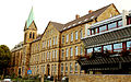
Fishing school on Bramstrasse

Naked mill on the Nette

Christ the King Church


.jpg)
Sports
There are two sports clubs in Haste, the TuS Haste and the Haste game association. The municipal sports and leisure pool Nettebad is located directly on the border with Haste, but belongs to the Sonnenhügel district.
people
The sculptor Fritz Szalinski was born in Haste in 1905.
Cultural monuments

- The Karlsteine , one of the most famous large stone tombs from the Neolithic Age in the Osnabrück area, are located northwest of Haste.
- The Östringer stones , as well as the Karlsteine station on the street of megalithic culture in Osnabrück, are located east of Haste.
Web links
- Quarterly information from the Department of Urban Development and Citizen Participation, Statistics Division, 4/2008 (PDF file; 1.49 MB)
- City of Osnabrück, Department for Urban Development and Public Participation -Statistics-, 11/2009 (PDF file; 35.40 kB)
- www.treffhaste.de
Individual evidence
- ↑ City of Osnabrück, statistics, size of the city districts and statistical districts 11/2011 (PDF file)
- ↑ Municipal statistics and monitoring portal Osnabrück (KOSMOS): Population - residents with main residence , osnabrueck.de, accessed on August 3, 2019
- ^ Map of the Osnabrück districts , City of Osnabrück - Geodata Service, accessed on January 19, 2017.
- ↑ Joachim Dierks: National Socialists decree to be incorporated - 80 years ago today, the Haster people became Osnabrückers against their will. In: noz.de. NOZ Medien, April 1, 2020, accessed on April 2, 2020 .
- ↑ https://www.noz.de/lokales/osnabrueck/artikel/4646/strassenkunde-in-osnabruck-die-hardinghausstrasse-erinnert-an-den-letzt-haster-burgermeister#gallery&0&0&4646 NOZ on November 7, 2012: " Street studies in Osnabrück: Hardinghausstraße reminds of the last mayor of Haster "; accessed on May 7, 2018
- ↑ City of Osnabrück, statistics, population by district 2004 - 2014 (PDF file)
- ↑ https://geo.osnabrueck.de/kosmos/bericht_daten_statistik/atlas.html?select=Stadtstrich KOSMOS - Municipal Statistics and Monitoring Portal Osnabrück Figures 2014 - 2019
Atter | Therefore / Gretesch / Lüstringen | Dodesheide | Eversburg | Fledder | Garden location | Port | Haste | Lightening | Downtown | Limestone hill | Nahne | Pye | Schinkel | Schinkel-Ost | Schölerberg | Sun hill | Sutthausen | Voxtrup | Westerberg | Weststadt | Widukindland | desert
Coordinates: 52 ° 18 ' N , 8 ° 3' E