
Cute (bunny)
| Nice | ||
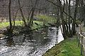
![Naked mill (founded in 1235 [1]) on the Nette in the Haste district of Osnabrück](https://de.wikipedia.org/wiki/Datei:Osnabr%C3%BCck_Nackte_M%C3%BChle.JPG) Nackte Mühle (founded in 1235) on the Nette in the Haste district of Osnabrück |
||
| Data | ||
| location | Osnabrücker Bergland , western Lower Saxony | |
| River system | Ems | |
| Drain over | Hase → Ems → North Sea | |
| source |
Hair 52 ° 19 ′ 35 ″ N , 8 ° 11 ′ 13 ″ E |
|
| Source height | 127 m above sea level NN | |
| muzzle | at the port of Osnabrück in Osnabrück in the Hase Coordinates: 52 ° 17 '38 " N , 8 ° 1' 27" E 52 ° 17 '38 " N , 8 ° 1' 27" E |
|
| Mouth height | 62 m above sea level NN | |
| Height difference | 65 m | |
| Bottom slope | 3.3 ‰ | |
| length | 19.5 km | |
| Left tributaries | Niederrielager Bach, Landwehrgraben | |
| Right tributaries | Kriekbeeke, Stone Birch, Bruchbach, Lechtinger Bach | |
| Big cities | Osnabrück | |
| Communities | Vehre , Icker , Wallenhorst | |
The Nette is a river in the Osnabrück mountainous region . It rises west of Ostercappeln in the Haaren district and flows into the Hase in Osnabrück not far from the Osnabrück harbor . The river is 19.5 kilometers long, making it the largest body of water that flows into the Hase in the urban area of Osnabrück.
Except for the source area, the upper course of the Nette has been expanded from the western part of Vehrtes via Icker to Wallenhorst-Rulle and the bank has been paved almost continuously. In the vicinity of Vehre , the Nette flows a short distance on the edge of the Wiehengebirge through forest, where the natural state of the stream has been preserved. It meanders through a deciduous forest of beech and oak , and alder trees stand on the banks . Many large boulders and three barrows , the Oestringer Stones I – III , are on the road, in the forest and in the stream bed. The Nettetal between Rulle and Osnabrück below the Wittekindsburg is one of the most scenic regions in the Osnabrück region . The megalithic graves of Oestringer Steine are located in the area of the Nette .

The nice one in the headwaters in Ostercappeln-Oberhaaren

Nice tributary in Vehre

Wetland of the Nette at Vehrter Bahnhof

The Nice at Knollmeyers Mühle below the Wittekindsburg

The Nette and Knollmeyers mill (first mentioned in 1253)
The nice one at Knollmeyer's mill


There are two renaturation stretches in the Osnabrück urban area : in the estuary of the Nette an oxbow lake was created in 1991 and in 1993 as part of the "Osnabrück River Protection Program " oxbow lakes , ponds, reed and succession areas were created and trees were planted at the Nettebad . In the area of the Osnabrück port it crosses under the branch canal by means of a culvert and flows into the Hase a good two hundred meters later.
Individual evidence
- ^ Association for youth welfare eV: Osnabrück | Naked Mill | Story . Vfjh.org. Archived from the original on May 24, 2010. Info: The archive link was automatically inserted and not yet checked. Please check the original and archive link according to the instructions and then remove this notice. Retrieved June 8, 2010.
- ↑ Wilhelm Borgmeier (Ed.): Vehre von then until now , 2006, p. 131
- ↑ Knollmeyer's watermill in the Nettetal . rulle.de. Retrieved June 8, 2010.