
Wierau
| Wierau | ||
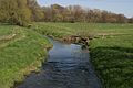
 The Wierau near Wissingen not far from where it flows into the Hase |
||
| Data | ||
| location | Wiehengebirge , Osnabrücker Bergland , western Lower Saxony | |
| River system | Ems | |
| Drain over | Hase → Ems → North Sea | |
| source | in the Bad Essen district of Rattinghausen in the Wiehen Mountains 52 ° 16 ′ 40 ″ N , 8 ° 21 ′ 12 ″ E |
|
| Source height | 150 m above sea level NN | |
| muzzle | northeast of Werscher Berg not far from Lake Linner in the Bissendorf district of Wissingen in the Hase Coordinates: 52 ° 15 ′ 8 ″ N , 8 ° 12 ′ 48 ″ E 52 ° 15 ′ 8 ″ N , 8 ° 12 ′ 48 ″ E |
|
| Mouth height | 74 m above sea level NN | |
| Height difference | 76 m | |
| Bottom slope | 5.4 ‰ | |
| length | 14 km | |
| Left tributaries | Hilmkebach, Hiddinghauser Bach | |
| Right tributaries | Galbrinksbach, Westermoorbach | |
| Communities | Bad Essen , Bissendorf | |
The Wierau is a 14 km long right tributary of the Hase . It rises at about 150 m altitude in the Wiehengebirge in the Bad Essen district of Rattinghausen and flows into the Hase northeast of Werscher Berg not far from Lake Linner in the Bissendorfer district of Wissingen. On her way to the mouth she feeds u. a. the moats of the Schelenburg near Schledehausen.

The Wierau north of Schledehausen
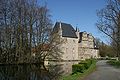
The Schelenburg with its moat fed by the Wierau

The Wierau at the Schledehausener outdoor pool
Mouth of the Wierau (left) into the Hase


Individual evidence
- ↑ Archived copy ( memento of the original dated December 17, 2005 in the Internet Archive ) Info: The archive link was inserted automatically and has not yet been checked. Please check the original and archive link according to the instructions and then remove this notice. .
- ↑ http://www.bfn.de/geoinfo/fachdaten/
- ↑ http://navigator.goettingerland.de/
Web links
Commons : Wierau - Collection of images, videos and audio files