
Alfsee
| Alfsee | |||||||||||
|---|---|---|---|---|---|---|---|---|---|---|---|
 |
|||||||||||
|
|||||||||||
|
|||||||||||
| Coordinates | 52 ° 29 '16 " N , 7 ° 58' 29" E | ||||||||||
| Data on the structure | |||||||||||
| Construction time: | 1971-1983 | ||||||||||
| Crown length: | 320 m | ||||||||||
| Base width: | 17 m | ||||||||||
| Data on the reservoir | |||||||||||
| Altitude (at congestion destination ) | 37 m above sea level NN | ||||||||||
| Water surface | 2.2 km² (220 ha) | ||||||||||
| Reservoir length | 2.88 km | ||||||||||
| Reservoir width | 1.35 km | ||||||||||
| Storage space | 20 million m³ | ||||||||||
| Catchment area | 660 km² | ||||||||||
| Particularities: |
Abundant bird life |
||||||||||
 |
|||||||||||

The Alfsee (official name: Alfhausen-Rieste flood retention basin) is a 2.2 km² reservoir in the north of the Osnabrück district in Lower Saxony ( Germany ).
It serves as a flood retention basin for the catchment area of the Hase and as a local recreation area .
geography
The Alfsee is located in the northern Bramgau in the Osnabrücker Land . It is located around 25 km north of Osnabrück and 8 km north of Bramsche, southeast of the Ankumer Höhe . About 95 percent of its area belongs to the municipality of Alfhausen to the west , after which the reservoir is named. The rest, a bay in the east of the lake, belongs to the municipality of Rieste to the east .
Lake world
Four lakes
The water surface of the Alfsee covers 2.2 km², the shore length approx. Seven kilometers. Its maximum length is 2.88 km in a north-south direction. In the west-east direction it is up to 330 m wide in the south and up to 1,350 m in the north. Its storage volume is 20 million m³ at a water depth of up to 2 m.
Immediately to the south, where the artificially created water supply from the Hase flows into the Alfsee lake world, there is a small sedimentation basin in front of the actual reservoir , from which the water flows into the lake via an overflow threshold about 330 m long .
Directly east of the Alfsee is the small Dubbelausee , which is a maximum of 400 m in west-east direction and up to 360 m in north-south direction and is 37 m above sea level. NN lies.
Immediately to the north-east of the Alfsee is a reserve basin in front of a small nature reserve , which is a maximum of 700 m long in north-south direction and up to 425 m wide in west-east direction.
Inflow and outflow
Just north of the town of Bramsche, an artificially created feeder branches off from the Hase, which carries water from the south over a length of about 4.5 km into the lake world of the Alfsee. The water flowing out of the Alfsee runs over an equally artificially constructed and approximately 1.3 km long drain directly west past the reserve basin to the north of the Alfsee , after which it flows north over the canalized and approximately 2.5 km long lower course of the Ueffelner Aue , which passes the lake landscape in a south-north direction immediately west of Alfhausen, flows back to the river Hase.
Highest filling quantities
A full utilization of the absorption capacity of the Alfsee and the reserve basin has not yet been required.
The highest levels were:
- 18.2 million m³ in 1998 after hurricane Xylia
- 11.7 million m³ in 2010 according to Tief Cathleen
- 11.1 million m³ in 2008
History and tourist offers

With the "General Plan for Water Regulation in the Hasegebiet" of January 17, 1964, a flood retention basin in the area of the municipalities of Alfhausen and Rieste was mentioned for the first time. This should avert the constant danger of flooding on the lower reaches of the Hase and thus promote agriculture. Even with small to medium floods the hare stepped over its banks and flooded large areas.
A special department for “rabble regulation” was set up in the Osnabrück Water Management Office for the construction. She supervised and planned the construction of the Alfsee with an office in the Alfhausen farmers' association Heeke. The construction work for the Alfsee began in 1970 with clearing and dike construction work on the future lake area. The planned areas were even prepared for construction year-round in shifts. In 1976 Riester Straße was moved to the Trenndeich to make room for the lake and the reserve basin.
The 330 m long overflow threshold, the inlet of the Alfsee, was built in 1974 with a 10 hectare sedimentation basin. This is where sand and alluvial particles are supposed to settle, which would worsen the water quality of the lake. The outlet structure was also built in 1974.
The distribution structure in Sögeln was completed in the summer of 1980, where the separation of the Tiefen Hase from the supply line was established. In 1981 the ring dike was completed, the sand was taken from the Dubbelausee. The first trial damming was planned for autumn 1981, however, due to a severe storm with flooding, it was necessarily completed in spring. In order to test the effects on the environment and groundwater, the first official test dam was carried out in January 1982. With a water level of four meters, there was hardly any influence on the groundwater in the closer region. On October 28, 1998, during one of the largest floods since 1946, the main and reserve basins were flooded with 18 million cubic meters of hare water and the lower reaches of the hare were protected from severe flooding.
From 1976 a holiday park was built in the area of the village of Rieste on the east bank. Today there are, among other things, holiday homes, several campsites and the Ringhotel Alfsee Piazza. Next to the campsites is the Dubbelausee with three water skiing facilities and a lido. Nearby there is a go-kart track, the children's car park, the “Bullermeck” play barn, the “Alfsee maze adventure land” and various restaurants. The Alfsee is also popular with anglers , especially because of the occurrence of tench .

The reservoir was initially used for water sports; a boat harbor with boat rental and a sailing school. It thus offered the opportunity for sailing, surfing and pedal boating. In the meantime, the reservoir has largely been declared a bird sanctuary, so these areas are closed to water sports.
The Alfsee-Rieste youth hostel, which was inaugurated in 2000, is located near the recreation facilities and has 172 beds. In 2016 there were over 25,200 overnight stays here.

The Archehof Arche Alfsee was built near the holiday park in 1998 . The facility is part of a network of facilities supported by the Society for the Preservation of Old and Endangered Pet Breeds (GEH) , through which old pet breeds threatened with extinction are to be protected. Since 2014, the Archehof has been allowed to call itself " Archepark " due to its pet park character and the large number of different endangered livestock breeds . The Alfsee Arche houses u. a. Poitou donkeys , woolly pigs , Skudden , Diepholzer geese , Lake Fields chicken and Vorwerk chicken .
Transport links
The Alfsee, which is located southeast of Alfhausen a few hundred meters east of the B 68 , can be reached from this federal road and from the Neuenkirchen-Vörden junction of the A 1 passing slightly to the east . The Rieste train station, which is served every hour from Bremen (via Delmenhorst) and Osnabrück, is only around 1,800 m from the Alfsee.
photos

Open air cinema
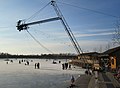
Water ski facility of the Dubbelausees (winter)
Former boat harbor

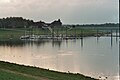
Overflow

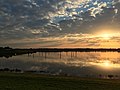
Panoramic picture of the Alfsee
View from the dam on the Alfsee


See also
Individual evidence
- ↑ https://www.nlwkn.niedersachsen.de/download/58244/Alfsee.pdf 14th lake report Alfsee des Nlwkn (pdf)
- ↑ https://www.pegelonline.nlwkn.niedersachsen.de/Karte Information on the extreme values of the Alfsee
- ↑ Christof Haverkamp: Regulation of the rabbit , in The development of the Emsland in the 20th century as an example of state regional economic development. P. 164
- ↑ The Alfsee - planning and reality , in Alfhausen a chronicle in pictures. Self-published by the community of Alfhausen. Second edition 2011. p. 168
- ↑ The Alfsee - planning and reality , in Alfhausen a chronicle in pictures. Self-published by the community of Alfhausen. Second edition 2011. p. 169
- ^ Society for the preservation of old and endangered domestic animal breeds eV (GEH): Arche-Park No. 13: Arche-Alfsee
Web links
- Alfhausen-Rieste flood retention basin , at nlwkn.niedersachsen.de
- Alfsee, Lower Saxony , on talsperren.net
- Alfsee water profile, on anglermap.de