That's why / Gretesch / Lüstringen
|
|||
|---|---|---|---|
Map:
|
|||
| Basic data | |||
| Area : | 14.34 km² | ||
| Residents : | 8220 As of December 31, 2019 | ||
| Population density : | 570 inhabitants / km² | ||
| Postal code : | 49086 | ||
| Primaries : | 0541 05406 (parts of Darum) |
||
| structure | |||
| District number: |
21st |
||
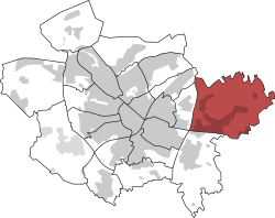
Darum / Gretesch / Lüstringen is a district of the Lower Saxon city of Osnabrück with 8,220 inhabitants (12/2019) spread over an area of 14.34 km². It is located in the eastern part of the city and originally consists of these three localities and a part of the former district of Schinkel. There is the Evangelical Lutheran Church of St. Peter and the Catholic Church of St. Mary. The district is located on the street of the megalithic culture .
history
The area of this district has a long history of settlement, which is still visible today in the form of several Neolithic large stone graves such as the Gretescher Steinen , the Sundermannsteinen and the Teufelssteinen in Voxtrup , near the border with Lüstringen . Also in Voxtrup, near the border to Lüstringen, the copper treasure from Osnabrück was discovered in 2016 with an ax and three neck and chest jewelry ( lunulae ). Subject to the more detailed results, the archaeologists estimated the age of the finds to be roughly 4500 years, which corresponds to the Neolithic . The President of the Lower Saxony State Office for Monument Preservation, Stefan Winghart, considers a cultural-sociological connection to the above-mentioned large stone graves to be very likely. Both the megalithic graves and probably the copper treasure are connected to an old long-distance path that led southeast around today's city of Osnabrück through the area of the later municipality of Lüstringen and crossed the Hase by a ford .
The farmers Darum, Gretesch and Lüstringen with Icker, Vehre, Powe and Haltern originally belonged to the parish of Belm, which was established in the 9th century . From the 11th century onwards, the three places formed the Darum-Gretesch-Lüstringen brand cooperative . Later, the three places developed as independent communities in the district of Osnabrück until they were incorporated into Osnabrück as part of the Lower Saxony regional reform that came into effect on July 1, 1972.
From the late 13th century to the end of the 15th century there was a municipality in the northeastern part Gräftenburg whose artificially high, rectangular inner surface was completely surrounded by a multipart moat (graft). On the north side there was a bailey . The castle was owned by the noble family of the same name until the 14th century. In 1457 it was sold to the Wüllneramt in Osnabrück. With the decline of the Osnabrück cloth industry at the end of the 18th century, the Wüllneramt was forced to sell the castle to the city of Osnabrück in 1787. After their abandonment, the entire area was leveled, so today only individual bumps can be seen near the Schoeller paper mill. To the south of the castle there was still a fortification, the so-called Gretescher Turm , which is also no longer there today.
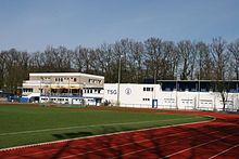
The Felix Schoeller paper mill located there was and is of outstanding importance for the economic development of Gretesch, which, thanks to its trade tax, made the municipality one of the richest places in Germany until it was incorporated. During this time the small community operated its own indoor swimming pool and had a sports stadium built with a synthetic track , which is now the home of TSG Burg Gretesch . At the opening in September 1970, Gert Metz ran a new European record and world best time in the 100-meter run with 10.0 seconds.
Other important companies based in Darum / Gretesch / Lüstringen are DIOSNA Dierks & Söhne , a leading manufacturer of systems for food and pharmaceutical production, and HR Group GmbH , the parent company of the Reno shoe retail chain .
Population development
The population development of the Darum / Gretesch / Lüstringen district:
|
|
|
|
Transport links
The district is located east of the federal motorway 33 and is connected to it via the Osnabrück-Lüstringen junction . Until 1978 the Lüstringen train station existed on the main line Löhne – Osnabrück – Rheine in the south of the district . The Schoeller paper mill also has a siding .
literature
- Römisch-Germanisches Zentralmuseum Mainz (Hrsg.) : Guide to prehistoric and early historical monuments - The Osnabrücker Land III. Vol. 44, Verlag Philipp von Zabern, Mainz 1979
Web links
Individual evidence
- ↑ Municipal statistics and monitoring portal Osnabrück (KOSMOS): Population - residents with main residence , osnabrueck.de, accessed on August 3, 2019
- ↑ City of Osnabrück, statistics, size of the city districts and statistical districts 11/2011 (PDF file)
- ↑ Archived copy ( Memento of the original dated August 12, 2010 in the Internet Archive ) Info: The archive link was inserted automatically and has not yet been checked. Please check the original and archive link according to the instructions and then remove this notice.
- ↑ Archived copy ( Memento of the original dated August 12, 2010 in the Internet Archive ) Info: The archive link was inserted automatically and has not yet been checked. Please check the original and archive link according to the instructions and then remove this notice.
- ↑ Archived copy ( Memento of the original dated August 12, 2010 in the Internet Archive ) Info: The archive link was inserted automatically and has not yet been checked. Please check the original and archive link according to the instructions and then remove this notice.
- ↑ Römisch-Germanisches Zentralmuseum Mainz (ed.): Guide to prehistoric and early historical monuments - Das Osnabrücker Land III , vol. 44, 1979, p. 27ff
- ↑ Osnabrücker Probe rescues valuable jewelry in Neue Osnabrücker Zeitung from July 27, 2016
- ↑ Documentary film Der Kupferschatz von Osnabrück on Youtube (approx. 16 minutes)
- ^ Federal Statistical Office (ed.): Historical municipality directory for the Federal Republic of Germany. Name, border and key number changes in municipalities, counties and administrative districts from May 27, 1970 to December 31, 1982 . W. Kohlhammer GmbH, Stuttgart / Mainz 1983, ISBN 3-17-003263-1 , p. 252 .
- ↑ Rudolf vom Bruch: The knight seats of the Principality of Osnabrück . ND Osnabrück 2004, p. 126f.
- ^ Burg Gretesch ( Memento from June 15, 2009 in the Internet Archive )
- ↑ Gretescher Turm ( Memento from June 15, 2009 in the Internet Archive )
- ↑ City of Osnabrück, statistics, population by district 2004 - 2014 (PDF file)
- ↑ https://geo.osnabrueck.de/kosmos/bericht_daten_statistik/atlas.html?select=Stadtstrich KOSMOS - Municipal Statistics and Monitoring Portal Osnabrück Figures 2014 - 2019
Coordinates: 52 ° 16 ' N , 8 ° 8' E


