Fresenburg
| coat of arms | Germany map | |
|---|---|---|

|
Coordinates: 52 ° 53 ' N , 7 ° 18' E |
|
| Basic data | ||
| State : | Lower Saxony | |
| County : | Emsland | |
| Joint municipality : | Lathen | |
| Height : | 9 m above sea level NHN | |
| Area : | 21.59 km 2 | |
| Residents: | 904 (Dec. 31, 2019) | |
| Population density : | 42 inhabitants per km 2 | |
| Postal code : | 49762 | |
| Area code : | 05933 | |
| License plate : | Tbsp | |
| Community key : | 03 4 54 013 | |
| LOCODE : | DE FRE | |
| Community structure: | 3 districts | |
| Address of the municipal administration: |
Schulstrasse 6 49762 Fresenburg |
|
| Website : | ||
| Mayor : | Gerhard Führs ( CDU ) | |
| Location of the municipality of Fresenburg in the district of Emsland | ||
Fresenburg is a municipality in the Emsland district in Lower Saxony .
geography
Geographical location
Fresenburg lies on the Ems and the Dortmund-Ems Canal and between the cities of Papenburg and Meppen . The community belongs to the Lathen community.
Since the districts of Fresenburg and Düthe are completely surrounded by water (in the west the Ems, in the east the Dortmund-Ems Canal) one can speak of an island location in these districts.
Neighboring communities
Neighboring communities are in the north the community Kluse in the integrated community Dörpen , in the east the community Renkenberge , in the south the communities Lathen and Niederlangen and in the west the community Sustrum .
Community structure
The three districts of the municipality are:
- Fresenburg
- Duthe
- Melstrup
history
Explanation of the place name
Old names of the place are 1226 Vresenberghe, 1290 Vresenberg, 1315 Vresenberghe and 1326 Vresenberghe. The Fresenburg near Lathen is eponymous. The castle dates from the time when the Ravensbergers in the Emsland fought with the Tecklenburg people on the Hümmling for ownership. The exact time of its construction is not known. It is first mentioned as Vresenberghe 1226, but it may be a few decades older. The place name contains the Low German component "Frese" for "Friese".
Population development
|
|
|
politics
Municipal council
The municipal council from Fresenburg consists of 9 council members.
(Status: 2016 local elections)
mayor
The honorary mayor has been Gerd Führs since November 21, 2016, his deputy is Heinrich Ahrens.
coat of arms
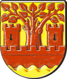
"In Gold golden wave shield flow from a red battlements growing a linden with three strong branches, accompanied by two red crenellated towers." So described Dr. Korn the representation, which he revised several times in 1991 on the basis of suggestions from Fresenburg, Düthe and Melstrup.
The castle with the two towers refers to the castles Fresenburg and Düthe. The linden tree symbolizes the " Theiort " , an ancient court in Düthe. A linden tree was usually the sign of a place of judgment. The three strong branches of the tree represent the three districts of the municipality . The waves in the Schild river indicate that the old Fresenburg was a waterfront location. In addition, the water of the Ems and the Dortmund - Ems Canal plays an important role for the community.
The colors gold and red are the colors of the coat of arms of the former duchy of Münster , to whose Niederstift the municipal area belonged from 1252 to the end of the Old Kingdom in 1803.
Attractions
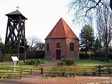
- Old castle chapel with bell tower in the Fresenburg district
- Lock system in the Düthe district
- Small boat harbor in the district of Fresenburg
Regular events
- Schützenfest, the 1st weekend in July, Sunday and Monday
- Indoor riding tournament of the RFV (Reit- und Fahrverein Lathen und Umgebung eV) end of January, beginning of February in the Joh.-Ehrens-Reithalle
- Summer riding tournament of the RFV in April / May on the outdoor area
- RFV riding day in Advent with Nickolaus celebration
- Cup tournament from SV Fortuna on Pentecost Sunday
Economy and Infrastructure
traffic
Fresenburg can be reached via the A31 motorway (exit Lathen). The distance to the motorway is about 10 km. Fresenburg can also be reached via the B70 federal road. The railway network of the Rheine – Norddeich Mole railway line can be reached via Lathen station . The connection to the Dortmund-Ems Canal is given with a port.
education
The place has a primary school . The dwarf school has been run as an open all-day school since 2008 . The 1st and 2nd grade and the 3rd and 4th grade are taught here together, only major subjects are excluded from this. Their playground includes a small soccer field, a climbing frame and a basket swing. There has also been a cafeteria since 2010. The headmistress is Helena Hopster, staff member is Gaby Weseler.
literature
- Ernst Förstemann, Hermann Jellinghaus (editor): Old German name book , Volume II, 1 and 2: Place names , Bonn 1913/1916 (Reprint: Volume II, 2, Hildesheim 1967/1983, ISBN 3-487-01733-4 )
- Hermann Abels: The place names of the Emsland, in their linguistic and cultural-historical significance , Ferdinand Schöningh Verlag, Paderborn 1929
- Werner Kaemling: Atlas on the history of Lower Saxony , Gerd J. Holtzmeyer Verlag, Braunschweig 1987, ISBN 3-923722-44-3
Web links
Individual evidence
- ↑ State Office for Statistics Lower Saxony, LSN-Online regional database, Table 12411: Update of the population, as of December 31, 2019 ( help ).
- ^ Jürgen Udolph (research): The "place name researcher". In: website NDR 1 Lower Saxony . Archived from the original on July 29, 2016 ; accessed on August 4, 2019 .
- ^ Emsland / Bentheim, Contributions to History, Volume 10
- ↑ Fresenburg primary school


