
Holtorf (Nienburg)
|
Holtorf
City of Nienburg / Weser
|
||
|---|---|---|
 |
||
| Height : | 26 m above sea level NN | |
| Incorporation : | March 1, 1974 | |
| Postal code : | 31582 | |
| Area code : | 05021 | |
Location of Holtorf in Lower Saxony |
||

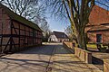
Holtorf is a district of the city of Nienburg / Weser in the Lower Saxony district of Nienburg / Weser .
geography
Holtorf is 3.5 km north of the city center of Nienburg. The Weser flows north in 1.5 km and west in 2 km from the town . Neighboring towns are - clockwise from the north - Rohrsen , Heemsen , Erichshagen-Wölpe , Nienburg (core area) and Drakenburg .
history
The first documented mention of the settlement of Holtorf was in 1096. The agricultural church village was temporarily the seat of a superintendent . Towards the end of the 19th century, the Wilhelmshütte glass factory was built after clearing a forest southwest of the village. As a result, the number of inhabitants increased and Holtorf achieved a certain level of prosperity through the glass industry and the crafts and trading companies associated with it.
Since 1 March 1974 Holtorf is a village of the town of Nienburg / Weser.
politics
Holtorf has its own local council with 9 local council members. The local mayor is Cornelia Feske.
- coat of arms
Holtorf has its own coat of arms .
Culture and sights
_IMG_9990.jpg)
Buildings
- Vogeler's house is a timber-framed farmhouse built in 1803, which has been restored down to the last detail and has been used as an event center in the village ever since. This is also the seat of the Holtorf Heimatverein , which played a key role in the restoration.
- The parish church of St. Martin in the Protestant parish of Holtorf was first mentioned in 1096. Today's brick - timbered church , which is essentially medieval, was built from an originally Romanesque building in over ten construction phases . The year 1580 carved over the south door probably stands for the end of the last building phase. The Romanesque baptismal font was restored in 2008, an altar design by André Alder remained unworked.
Green spaces and recreation
- Holtorf outdoor pool
Sports
- Archers Holtorf
- Holtorfer SV
- Holtorfer tractor friends
- Holtorfer Schießsport und Schützenfestverein e. V.
- FC Holtorf e. V.
- Association for the promotion and maintenance of the open-air swimming pool on the Dobben

Guide Mühlbach
Town view

View from the Mühlbachbrücke
_IMG_9994.jpg)
_IMG_0003.jpg)
_IMG_9995.jpg)
Economy and Infrastructure
Public facilities
The fire protection of the place is ensured by the volunteer fire brigade Holtorf.
traffic
Holtorf is located directly on the federal highway 215 , which leads from Verden (Aller) via Nienburg to Minden . The B 6 from Bremen to Hanover runs south in a distance of 2 km.
Web links
Individual evidence
- ^ Federal Statistical Office (ed.): Historical municipality directory for the Federal Republic of Germany. Name, border and key number changes in municipalities, counties and administrative districts from May 27, 1970 to December 31, 1982 . W. Kohlhammer GmbH, Stuttgart and Mainz 1983, ISBN 3-17-003263-1 , p. 198 .
- ↑ Heimatverein Holtorf in Vogeler's house
- ↑ Romanik.de: St. Martin Church Nienburg-Holtorf. Retrieved July 9, 2013 .
- ^ Altar design for St. Martin's Church in Holtorf. (No longer available online.) Archived from the original on March 4, 2016 ; Retrieved July 9, 2013 . Info: The archive link was inserted automatically and has not yet been checked. Please check the original and archive link according to the instructions and then remove this notice.