
Oldendorf (Melle)
|
Oldendorf
City of Melle
Coordinates: 52 ° 14 ′ 22 ″ N , 8 ° 19 ′ 3 ″ E
|
|
|---|---|
| Height : | 101 (76.0-232.5) m above sea level NHN |
| Area : | 24 km² |
| Residents : | 4779 (March 5, 2009) |
| Population density : | 199 inhabitants / km² |
| Incorporation : | July 1, 1972 |
| Postal code : | 49324 |
| Area code : | 05422 |
 Location of Oldendorf in Melle
|
|
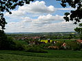
Oldendorf is a north-western district of Melle in Lower Saxony on the southern slope of the Wiehen Mountains between the large cities of Osnabrück and Bielefeld .
.JPG)
geography
.JPG)


Districts
The districts of Oldendorf, Föckinghausen and Westerhausen, seen from east to west at the southern foot of the Wiehengebirge, as well as the district of Oberholsten to the north of Oldendorf and the district of Niederholsten to the north of Westerhausen belong to the Meller district of Oldendorf.
location
The area in the Oldendorf district is hilly in the north and largely forested. There is the ridge of the Wiehengebirge with the Hesterbrink ( Moselerberg ; 232.5 m) near Oberholsten, the highest elevation in the city of Melle, where the headwaters of the Hunte , the longest left tributary of the Weser, are also located . Over 70% of the drinking water of the entire city of Melle is obtained from the five large wells located below the Niederholsten farmers . The entire area is a landscape conservation area , 1,490 hectares are also a water conservation area and part of the TERRA.vita nature and geopark . Towards the east, the 220 m high Dietrichsberg protrudes with the wildlife park and the Diedrichsburg , which is also the landmark of Oldendorf. To the south, the area is first of the wave, agricultural landscape in the farming communities dominated Upper and Lower Holsten and the town Oldendorf, until finally becoming ever flatter the lowlands of Hase and Else achieved. The districts of Westerhausen and Föckinghausen are located there.
history
Oldendorf (Aldendorphe / Altes Dorf) is one of the 25 small original villages in the entire Grönegau (Graingau) in the 8th century . The original villages consisted of five to eight farms, a total of around 150 farms with around 1200 people. During excavations, finds have confirmed that Oldendorf belongs to the longest populated area of the city of Melle. Traces show that Oldendorf was built around 10,000 BC. Was inhabited and structures of settlements can date back to about 4000 BC. Be proven. One of the reasons for this choice of location was that an abundant water-bearing spring rose from the Westerhausener Berg. Early Germanic settlements have around 700 BC. Took place on the southwest slope of the Wiehengebirge near Westerhausen in the upper peasantry. Oldendorf was first mentioned in a document around the year 1000 in the register of the Corvey monastery in connection with the church. Oldendorf was first mentioned in a document in 1160. Since the first Meierhöfe were built from the Carolingian era , the village of Westerhausen with the Meyerhof was also currently being created . As underwood count, Meyer zu Westerhausen was also responsible for the wood court . Ober- and Niederholsten as well as Föckinghausen were first mentioned in a document in 1240. Three villages in Oldendorf are located on an old military road and an old trade route . This was moved from Osnabrück to Oldendorf in 1820–1825 and expanded as a road . New farmers and some craftsmen settled on this street . With the construction of the railway line from Löhne to Osnabrück in 1855, the change from a peasantry to an industrial location began in 1879 with the establishment of a stop in Westerhausen. From 1903 onwards, the Heroldsche drive belt factory , which had previously burned down in Melle and relocated to the train station in Westerhausen, ensured a strong upswing, which was continued by Westland-Gummiwerke's acquisition of the factory building and site in 1942 . In Oldendorf-Westerhausen there was no electric light until 1921. At that time the houses had an outhouse and a handle pump . The district and municipal roads were gravel or unpaved. A worker earned around 50 pfennigs an hour in the 1930s, with bread costing 45 pfennigs. The number of inhabitants in Westerhausen and Föckinghausen had more than doubled from 1903 to 1950, due to the railroad, industry and craft. The section of the federal motorway 30 (exit no.22), which was completed in 1976, caused an economic upswing in the districts of Westerhausen and Föckinghausen.
On July 1, 1972, Oldendorf was incorporated into the city of Melle.
.jpg)
coat of arms
The coat of arms of the Oldendorf district shows the red Diedrichsburg with a blue roof on a yellow background. The Welfenross coat of arms used previously had to be given to the Lower Saxony Ministry of the Interior in 1952 .
Population development
The following overview shows the population development of the former municipality of Oldendorf and the current district of Oldendorf.
|
|
|
|
Resident population of the Oldendorf community with territorial status as of May 27, 1970:
| date | Residents |
|---|---|
| May 17, 1939 | 672 |
| September 13, 1950 | 979 |
| June 6, 1961 | 819 |
| May 27, 1970 | 948 |
politics
The local mayor is Karin Kattner-Tschorn ( SPD ).
The following table shows the local election results since 2006.
| Local council Oldendorf: election results | |||||||||||||||||||
|---|---|---|---|---|---|---|---|---|---|---|---|---|---|---|---|---|---|---|---|
| CDU | SPD | Green | FDP |
Wählerge- Communities |
Individual applicants |
Others | total | electoral participation |
|||||||||||
| Electoral term | % |
|
% |
|
% |
|
% |
|
% |
|
% |
|
% |
|
% |
|
% | ||
| 2006-2011 | 24.8 | 4th | 63.8 | 10 | 7.7 | 1 | 3.8 | 0 | - | - | - | - | - | - | 100 | 15th | 52.9 | ||
| 2011-2016 | 20.8 | 3 | 61.1 | 9 | 14.5 | 2 | 3.6 | 1 | 100 | 15th | 53.0 | ||||||||
| Percentages rounded. | |||||||||||||||||||
Economy and Infrastructure
economy
.jpg)
There are a few larger companies in industry, including a. the office furniture manufacturer Assmann and Westland Gummiwerke . The very large transshipment warehouse of Logwin AG and the large warehouse of the dealer Thomas Philipps are also located in Oldendorf. The largest German insemination station , the Osnabrück Herdbook , is also located there. The district is mainly characterized by medium-sized businesses , rural agriculture and all other supply options in a district.
traffic
The Löhne – Rheine railway runs through the district of Westerhausen , where there is also a stop for the Wiehengebirgsbahn, which runs there every hour. The district of Oldendorf is integrated into the urban regional bus traffic by the Melle city bus . The departure no. 22 of the motorway A 30 or the European route E30 is 3km from Westerhausen removed.
education
Oldendorf has two primary school locations. The Oldendorf Primary School is currently attending 74 students and the Westerhausen Primary School 163 students (status: 9/2009). Kindergartens are located in the districts of Oldendorf and Westerhausen. Sports, soccer and tennis courts, as well as sports halls, are also available in the two villages.
Culture and sights
religion
The population of the entire district of Oldendorf is 63% Evangelical Lutheran , and 19% Roman Catholic . The remaining residents belong to other or no religious community.
Attractions
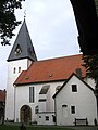
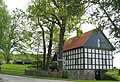
The single-aisled Evangelical Lutheran Church of St. Mary, which was completed with the stone church tower at the beginning of the 12th century, is worth seeing . The three-wing carved altar with its depictions of the Passion of Christ is particularly worth seeing . A small wooden church ( hermitage ), built by monks from the Corvey monastery and consecrated to St. Dionysius , had existed here as early as the 9th century . From 1255 Oldendorf has an independent parish. The Ostenwalde estate, which has been owned by the v. Family since 1343 . Vincke is, has a three-wing mansion and is east of Oldendorf on an old military road. Not far from there is a restored, functional oil mill from 1681. In the village of Westerhausen, a restored lime kiln from 1912 can be viewed as an industrial monument.
In the landscape on the southern slope of the Wiehengebirge, approx. 71 km of hiking trails are marked, which lead from five hiking parking lots past 91 benches, weather and barbecue huts and also point over the area of the game reserve on the Diedrichsberg. In the villages of Oldendorf and Westerhausen, large gyms, as well as a tennis and football stadium, offer opportunities to do sports. The outdoor swimming pool in Oldendorf and Mell's largest inland body of water, the 30,000 m² Grönegausee, are further local recreation areas.
In the direction of Niederholsten on the Oldendorfer Berg there is the beautifully situated Reiterwaldstadion as a location for large events. In Oberholsten, because of the area with little fog and artificial light, two observatories have settled, which were also involved in the Expo 2000 and have the largest Newtonian telescope that is used for public observation. The Planet Trail ends at the observatories, an astronomical educational trail that begins in Melle and replicates our solar system to scale.
View of Westerhausen
Marienkirche

Ostwalde estate

Westerhausen lime kiln
Former watermill house


Events
A medieval market has been held annually on the Diedrichsburg site for a few years.
Notes and sources
- Heimat- und Beautification Association Westerhausen-Föckinghausen eV (description of the district in the street plan)
- City of Melle brochure (BVB-Verlagsgesellschaft 2008)
- Chronicle of the community of Westerhausen for the 800 year celebration in 1962 (working group for community chronicle)
- Documents from the Oldendorf Citizens' Office .
- Districts of Oldendorf (map with street names).
- Districts of Oldendorf (view via satellite with street names).
- Homepage of the Oldendorf district
- Meller Jahrbuch 2007, Der Grönegau, Volume 25. ISBN 3-9811173-1-X
Individual evidence
- ↑ Documents from the Oldendorf Citizens' Office, page 5
- ^ Meller stories, by Wilhelm Knigge. Publisher: Buchhandlung Sutmöller, Melle 2002, page 9. ISBN 978-3-9807651-4-5
- ↑ Meller Jahrbuch 1995, Der Grönegau, Volume 13, Page 175
- ↑ Chronicle of the community of Westerhausen for the 800 year celebration in 1962, page 34
- ↑ Grönenberger Heimathefte, Part 1 1966, page 64
- ↑ Chronicle of the community of Westerhausen for the 800 year celebration in 1962, page 11, 113
- ↑ The Grönegau in the past and present. Published by the district of Melle 1968, page 181
- ↑ Chronicle of the community of Westerhausen for the 800 year celebration in 1962, page 113
- ↑ Chronicle of the community of Westerhausen for the 800 year celebration in 1962, page 115
- ↑ Westerhausen Home and Improvement Association (information board at the lime kiln)
- ↑ History of the A 30 motorway
- ^ Federal Statistical Office (ed.): Historical municipality directory for the Federal Republic of Germany. Name, border and key number changes in municipalities, counties and administrative districts from May 27, 1970 to December 31, 1982 . W. Kohlhammer GmbH, Stuttgart and Mainz 1983, ISBN 3-17-003263-1 , p. 257 .
- ↑ Coat of arms in the city of Melle ( page no longer available , search in web archives ) Info: The link was automatically marked as defective. Please check the link according to the instructions and then remove this notice.
- ↑ Explanatory report on the zoning plan of the city of Melle 2004, p. 46 ( Memento of the original from July 21, 2011 in the Internet Archive ) Info: The archive link was automatically inserted and not yet checked. Please check the original and archive link according to the instructions and then remove this notice. (PDF file; 6.50 MB)
- ↑ Meller Jahrbuch 1993, Der Grönegau, Volume 11, page 85
- ↑ Lower Saxony State Administration Office (Hrsg.): Municipal Statistics Lower Saxony 1970. Part 2: Population and Employment, Volume 5: District Osnabrück, Hanover 1973, p. 96.
- ↑ HP from the city part of Odendorf in Melle ( http://www.melle-oldendorf.de/ ) from January 27, 2016
- ↑ Meller Yearbook 2007, Der Grönegau, Volume 25 by Werner Imbrock
- ↑ Issue: The Oldendorfer Marienkirche and its altar, by Christa Meyer. Editor Ev. Lutheran parish of Oldendorf 1984, page 4
- ↑ Documents from the Oldendorf Citizens' Office, page 6
Alfhausen | Ankum | Bad food | Bad Iburg | Bad Laer | Bad Rothenfelde | Badbergen | Belm | Mountains | Bersenbrück | Tapping | Bissendorf | Boiled | Bramsche | Dissen at the Teutoburg Forest | Eggermühlen | Fürstenau | Gehrde | Georgsmarienhütte | Glandorf | Hagen am Teutoburg Forest | Hasbergen | Hilter at the Teutoburg Forest | Kettenkamp | Melle | Menslage | Merzen | Neuenkirchen | Nortrup | Ostercappeln | Quakenbrück | Rieste | Voltage | Wallenhorst
Melle-middle | Buer | Crushers | Gesmold | Neuenkirchen | Oldendorf | Riemsloh | Wellingholzhausen