East Kilver
|
East Kilver
community Roedinghausen
|
|
|---|---|
| Coordinates: 52 ° 12 ′ 27 ″ N , 8 ° 28 ′ 55 ″ E | |
| Height : | 68–130 m above sea level NN |
| Area : | 7.93 km² |
| Residents : | 1876 |
| Population density : | 237 inhabitants / km² |
| Incorporation : | 1st January 1969 |
| Postal code : | 32289 |
| Primaries : | 05226, 05223 |
|
Location of Ostkilver in Rödinghausen
|
|
Ostkilver is a district of the municipality of Rödinghausen in the northeast of the state of North Rhine-Westphalia . By 1968, Ostkilver formed an independent municipality in the Rödinghausen district. Like West Kilver, Ostkilver goes back to the Kilver House in Bruchmühlen , which was first mentioned in 851 .
Geographical location and sights
Ostkilver is located in the southwest of Rödinghausen at an altitude of between 120 m above sea level. NN and 68 m above sea level NN . The lowest point of Ostkilvers in the Elseauen is also the lowest point of the municipality of Rödinghausen. The Else flows through the district in the south from west to east. Ostkilver has around 1900 inhabitants who live in an area of 7.926 km², which corresponds to a population density of 236 inhabitants per km². Ostkilver is thus one of the districts of Rödinghausen with the lowest population density. The Rödinghausen community swimming pool is located in Ostkilver.
history
The place goes back to the Franconian royal court Gut Kilver (at that time called Villa Kilveri), which was first mentioned in a document in 851 a few decades after its presumed origin and is therefore also the oldest written settlement core of Rödinghausen. However, the estate is located in the Bruchmühlen district or West Kilver . In 820 a women's foundation was founded in Herford . Kilver (at that time still Kelver with three yards) is mentioned in the lifting role . The community of Rödinghausen gives the "official" first mention of Ostkilver as 1150. On January 1, 1969, the municipality of Ostkilver became part of the newly created municipality of Rödinghausen. In East Kilver, soldiers of the British Rhine Army were stationed in the Birdwood Barracks until 1993 . The 27 hectare site of the former barracks was renovated in 1997 and converted into a commercial area. The 1st Armored Division Transport Regiment Royal Corps of Transport (1 ADTR) was stationed here until 1993 , which was then moved to Gütersloh .
Population development
The following overview shows the population of Ostkilver according to the respective territorial status up to the incorporation into the municipality Rödinghausen on January 1st, 1969. A change of the territorial status resulted from the incorporation of inhabited areas of the municipality Rödinghausen on April 1st, 1938 (1933: 7 inhabitants). The numbers are census results . From 1871 and 1946, the figures relate to the local population and from 1925 to the resident population . Before 1871, the population figures were determined using inconsistent survey methods.
|
|
|
politics
The mayors of Ostkilver were:
- 1945–1968: Heinrich Petring
From 1969 the following local councilors headed the district :
- 1969– ?: Wilhelm Langhorst
- ? - ?: Karl-Heinz Schulte
coat of arms
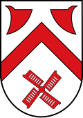
Blazon: In silver (white) two red ploughshares facing each other over a red rafter; underneath a red windmill wing.
The coat of arms of the old community is today without any municipal legal significance. The rafter is typical of the region's coat of arms. It stands for the former affiliation to the County of Ravensberg . The plowshares indicate the long-time owners of Haus Kilver , Gut Waghorst and Gut Böckel , in whose vicinity Ostkilver developed. The red ploughshare is featured in the family coat of arms by both the Westphalian noble families von Vinckes and von Bussche . The only difference between the coat of arms of Bruchmühlen (West Kilvers) is the windmill wing. The Bruchmühlen on longer sections of the Else and Kilverbach shows a water wheel of a watermill. On the other hand, the higher east Kilver, which only borders on the Else for a short stretch, had more windmills.
Education, transport and economy
The only school in East Kilver is a primary school. The railway line Bad Bentheim - Minden (KBS 375), on which the RB 61 "Wiehengebirgs-Bahn" runs every hour, Bad Bentheim - Rheine - Osnabrück - Bünde - Herford - Bielefeld , crosses the district in the extreme south. Ostkilver is connected to the trunk road network via its own driveway (which is, however, signposted as the Bruchmühlen exit ) on the A 30 Amsterdam - Bad Bentheim-Rheine-Osnabrück- Bad Oeynhausen .
The largest employer in East Kilver is the kitchen manufacturer Ballerina . In addition, numerous smaller companies have settled in the industrial area on the site of a former British barracks.
Individual evidence
- ↑ Martin Bünermann: The communities of the first reorganization program in North Rhine-Westphalia . Deutscher Gemeindeverlag, Cologne 1970, p. 75 .
- ↑ Municipal statistics of the state of North Rhine-Westphalia: population development 1816–1871 . State Statistical Office of North Rhine-Westphalia, Düsseldorf 1966, p. 192.
- ↑ Municipal statistics of the state of North Rhine-Westphalia: population development 1871–1961 . State Statistical Office of North Rhine-Westphalia, Düsseldorf 1964, pp. 380–381.


