Old burning
| Old burning | ||
|---|---|---|
|
The old burn from a distance of a few kilometers: the road marking post in the foreground "points" in the direction of the old burn |
||
| height | 291 m above sea level NN | |
| location | North Rhine-Westphalia , Germany | |
| Mountains | Wiehengebirge | |
| Coordinates | 52 ° 15 '54 " N , 8 ° 32' 40" E | |
|
|
||
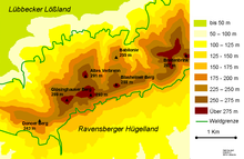
The old burn , which lies between the villages of Obermehnen and Oberbauerschaft , is 291 m above sea level. NN one of the higher mountains of the Wiehengebirge and the highest elevation in the city of Preußisch Oldendorf . The name is derived from the fact that the old Saxons offered burnt offerings on the top of this mountain.
The summit of the Alten Verbrenns itself is not on the main ridge of the Wiehengebirge, but is in front of it, similar to the Wurzelbrink . The summit is only 200 meters west of the border with the city of Lübbecke , so that the northeast flank of the mountain already belongs to Lübbecke.
To the northeast is the summit of the Babilonie .
Approx. The Kammweg runs 500 meters south of the mountain. It forms the border between the towns of Lübbecke and Preußisch Oldendorf in the north and the large community of Hüllhorst in the south. The Kammweg leads as Wittekindsweg on the Wiehengebirge from Osnabrück to Porta Westfalica and connects the Heidbrink in the east with the Straussberg (276 m above sea level) and in the west with Horsthöhe (275 m above sea level) and the Kniebrink (315 m above sea level). NN).
Web links
Individual evidence
- ^ Friedrich Möllering: Wittekind Sagen, Lübbecke, 1993, p. 13


