Nettelstedter mountain
| Nettelstedter mountain | ||
|---|---|---|
|
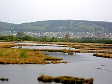
Nettelstedter Berg from the south in the area of the settlement Struckhof |
||
| height | 288.5 m above sea level NN | |
| location | south of Nettelstedt , North Rhine-Westphalia | |
| Mountains | Wiehengebirge | |
| Coordinates | 52 ° 17 ′ 42 " N , 8 ° 40 ′ 55" E | |
|
|
||
| Normal way | Footpath | |

The Nettelstedter Berg is a 288.5 m high mountain in the Wiehengebirge in the Minden-Lübbecke district .
location
The Nettelstedter Berg lies on the border between the town of Nettelstedt, which belongs to the town of Lübbecke and which gives it its name, and the town of Holsen , a district of the municipality of Hüllhorst , the summit point itself being in the area of the municipality of Hüllhorst. It is therefore the highest elevation of the aforementioned parts of the city or district and only 32 meters lower than the 320-meter-high Heidbrink , the highest mountain in the Wiehengebirge, which rises four kilometers to the west. The Nettelstedter Berg is located at a rather narrow point of the mountain range-like Wiehengebirge, which is only a kilometer wide here. Nevertheless, the mountain is one of the highest elevations in this mountain range. To the east of it, there is no longer a mountain in the entire Wiehengebirge, up to Porta Westfalica , that reaches the height of the Nettelstedter Berg.
Like almost all mountains in the Wiehengebirge, the Nettelstedter Berg has an elongated ridge summit (Egge) and is only separated from the peaks to the west by Dören . Therefore, the mountain is only partially perceived as a prominent peak.
Its summit has an old oak tree . There is also a telecommunications tower that can be seen from afar. Due to this facility, a paved driveway leads to the summit, but it is not approved for individual motorized traffic.
Hiking trails
The Wittekindsweg runs over the summit of the Nettelstedter Berg .
From the Nettelstedt open-air stage , the mountain can be comfortably hiked in 20 minutes.
Footnotes and individual references
- ↑ In some cases, its height is indicated on hiking maps as only 288 meters.


