Upper Hunte
|
Upper Hunte
|
||
| location | Southeast of Bad Essen | |
| surface | 110 ha | |
| Identifier | NSG WE 251 | |
| WDPA ID | 378333 | |
| Geographical location | 52 ° 16 ' N , 8 ° 24' E | |
|
|
||
| Sea level | from 62 m to 131 m | |
| Setup date | 01/25/2007 | |
| administration | NLWKN | |
Obere Hunte is a nature reserve in the Lower Saxon town of Melle and the municipality of Bad Essen in the Osnabrück district .
The nature reserve with the sign NSG WE 251 ( SCI DE3616301) is 110 hectares . It is congruent with the FFH area of the same name .
The nature reserve "Obere Hunte" is located southeast of Bad Essen and north of Melle in the area of the Wiehengebirge and the Osnabrück hill country . It places the upper reaches and floodplain area of the Hunte from the source area to the Rabber district belonging to Bad Essen (a little below the crossing of the former Wittlager Kreisbahn ) and the Bremkebach and Glanebach brooks that flow into the Hunte under protection.
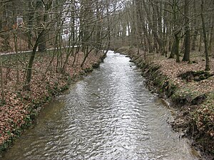
The upper Hunte is a flowing water that has not changed much by humans, with gravel banks and a constantly changing shape of the riverbed. The shore is almost completely lined with trees. In Auebereich are reed areas and Hochstaudenfluren to find. The adjacent areas are predominantly characterized by grassland , in some places there are also fields . The source area and the area of Wiehe mountain breakthrough as well as the by-carrying Glane Bach valley is predominantly forested, with a large part thereof, to be the location of typical coniferous forest represents.
The area has been a nature reserve since January 25, 2007. The responsible lower nature conservation authority is the district of Osnabrück.
Web links
- Nature reserve "Obere Hunte" in the database of the Lower Saxony State Office for Water Management, Coastal and Nature Conservation (NLWKN)
Individual evidence
- ↑ Various authors: Geographische Landesaufnahme: The natural spatial units in single sheets 1: 200,000 . Federal Institute for Regional Studies, Bad Godesberg 1952–1994. → Online maps


