Swatte Poele
|
Swatte Poele
|
||
| location | Northwest of Fürstenau , Osnabrück district , Lower Saxony | |
| surface | 4.3 ha | |
| Identifier | NSG WE 51 | |
| WDPA ID | 555518793 | |
| Geographical location | 52 ° 33 ' N , 7 ° 38' E | |
|
|
||
| Sea level | from 42 m to 43 m | |
| Setup date | August 1, 1976 | |
| administration | NLWKN | |
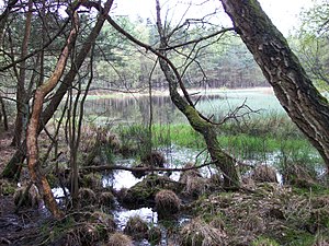
The Swatte Poele is a nature reserve in the Lower Saxony municipality of Bippen in the joint municipality of Fürstenau in the Osnabrück district .
The nature reserve with the registration number NSG WE 051 is 4.3 hectares in size. It is almost congruent with the FFH area of the same name . The area has been a nature reserve since August 1, 1976. The "Röthekuhle" natural monument, which was designated on January 20, 1970, was added to the nature reserve. The responsible lower nature conservation authority is the district of Osnabrück.
The nature reserve is located northwest of Fürstenau on the edge of the terminal moraine range of the Fensterberge. It places three heather ponds and the surrounding heather and forest areas under protection.
The heather ponds are surrounded by transitional and swinging lawn bogs and slowly silt up. In the area of the moors settle u. a. Peat moss , cotton grass, white schnabelried , bog lily , sundew, crowberry and marsh bear moss . Floating leaf plants can be found in the open water areas of the ponds , including water lily , frog bite and small water hose . Shore areas are occupied by sedges and rushes. Here u. a. Flooding plumes , common rush , onion rush , beak sedge and pond horsetail . Moist heather with bell heather and common heather stands adjoining the vineyard . Pipe grasses can be found here and there, in some places swamp forests with birch and pine trees . The higher-lying, dry areas in the protected area are predominantly occupied by pine forests. Occasionally junipers still occur in the protected area as a relic of the earlier grazing of the area.
The area is largely surrounded by forests, and in some places there are also agricultural areas.
Web links
- Nature reserve "Swatte Poele" in the database of the Lower Saxony State Office for Water Management, Coastal and Nature Conservation (NLWKN)
Individual evidence
- ^ Swatte Poele , Profiles of the Natura 2000 areas, Federal Agency for Nature Conservation . Retrieved September 30, 2019.
- ^ Fritz Koppe: The vegetation conditions of the moor area "Lonner Tannen". In: Publications of the Natural Science Association in Osnabrück , 1968, pp. 97–106 (PDF file, 3.5 MB). Retrieved September 21, 2017.


