Meller Mountains
| Meller Mountains | |
|---|---|
| Highest peak | Adolfsberg ( 220 m above sea level ) |
| location | Lower Saxony |
| part of | Osnabrück hill country |
| Coordinates | 52 ° 14 '0 " N , 8 ° 21' 42" E |

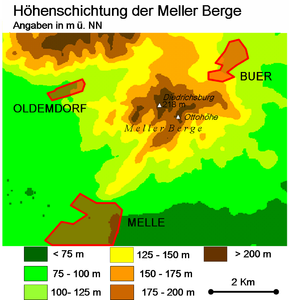
The Meller Mountains , also simply called Meller Berg , are small and up to a maximum of about 220 m above sea level. NHN high mountains of the Osnabrück hill country . They are located in the urban area of Melle in the district of Osnabrück in Lower Saxony .
geography
location
Parts of the nature and geopark TERRA.vita are located on the Meller Mountains . Although they rise somewhat set off around 6 km south of the main ridge of the Wiehengebirge , they are sometimes included in the latter. The small mountain range extends between the core town of Melle in the south, the districts of Bakum in the southwest and Eicken-Bruche in the south- east, which are part of Melle-Mitte , the Meller district of Buer in the northeast with its towns of Barkhausen in the east and Holzhausen in the north, and the district of Melle Oldendorf in the west; To the north-north-west lies the Meller Gut Ostenwalde . Most of it is drained by the southwest flowing Zwickenbach , whose water runs through the Else and Werre east to the Weser .
Natural allocation
The Meller mountains are in the natural landscape feature unit group Lower Weserbergland (no. 53) in the main unit Osnabrücker hills (535) and in the subunit Northern Osnabrücker hills (535.0) for the natural environment Meller highs (535.03). The landscape leads west to northwest into the natural area Schledehauser Hügelland (535.02). To the south it leads into the Elseniederung (531.10) natural area, which belongs to the subunit Else-Werre-Niederung (531.1), and to the east into the Quernheimer Hügelland natural area (531.01) and to the north into the Meesdorfer Heights (531.00) natural area , both in the Main unit Ravensberger Hügelland (531) belong to the subunit Quernheimer Hügel- und Bergland (531.0).
Surveys
The elevations of the Meller Mountains include - sorted by height in meters (m) above sea level (NHN):
- Adolfsberg (220 m, south-south-west summit ; 215 m, north-north-east summit )
- Diedrichsberg (219 m); with the Diedrichsburg
- Eickener Egge (207.5 m); with Ottoshöhe observation tower
- Stuckenberg (207.5 m); with the Friedenshöhe observation tower
Nature and landscape protection area
The closed forest area of the Meller Mountains covers around 8 km². Parts of the landscape protection area Wiehengebirge and Northern Osnabrücker Hügelland ( CDDA no. 390425; designated 2009; 288.348 km² ) lie on the mountains .
tourism
The Diedrichsburg stands on the Meller Berg . In the north of the mountains is the 2 km² large and enclosed wildlife park Diedrichsburg, which has existed since 1963 . He has a large population of semi-tame wild boars. It is particularly popular with tourists in spring when there are numerous newcomers in the park. On the Friedenshöhe, a side knoll of the Stuckenberg near Buer, stands the 28.6 m high observation tower Friedenshöhe , which was built in 1988 and which was expanded into a climatic tower in 2015 . On the Ottoshöhe , a hill on the Eickener Egge near the center of Meller, there is a 28.5 m high observation tower.
Ottoshöhe observation tower on the Eickener Egge
View to Diedrichsburg (2008)
Web links
Individual evidence
- ^ Sofie Meisel: Geographical Land Survey: The natural space units on sheet 83/84 Osnabrück / Bentheim. Federal Institute for Regional Studies, Bad Godesberg 1961. → Online map (PDF; 6.4 MB)
- ^ Sofie Meisel: Geographical Land Survey: The natural spatial units on sheet 85 Minden. Federal Institute for Regional Studies, Bad Godesberg 1959. → Online map (PDF; 4.5 MB)
- ↑ a b c Topographic map : with the Meller Mountains ( Memento of the original from March 28, 2017 in the Internet Archive ) Info: The archive link was inserted automatically and has not yet been checked. Please check the original and archive link according to the instructions and then remove this notice. (DTK 50; heights according to the top contour lines in AK 5 / 2.5), on natur-erleben.niedersachsen.de
- ↑ Map services of the Federal Agency for Nature Conservation ( information )
- ↑ Buer observation tower - Friedenshöhe / Stuckenberg on klimaturm.de (PDF; 76.4 kB)
- ↑ Klimaturm Melle-Buer on the website of the city of Melle
- ↑ Ottoshöhe observation tower on the Heimatverein Melle eV


