
Südhemmern
|
Südhemmern
municipality Hille
Coordinates: 52 ° 19 ′ 9 ″ N , 8 ° 47 ′ 14 ″ E
|
|
|---|---|
| Height : | 55 m above sea level NN |
| Area : | 7.61 km² |
| Residents : | 1342 (Dec. 31, 2002) |
| Population density : | 176 inhabitants / km² |
| Incorporation : | 1st January 1973 |
| Postal code : | 32479 |
| Area code : | 05703 |
 Location of Südhemmern in Hille
|
|
Südhemmern is a district of the Hille community in the Minden-Lübbecke district in East Westphalia .
It is essentially north of the Mittelland Canal and north of the Wiehengebirge . In the east, Südhemmern borders on the Hartum district , in the north on Nordhemmern , in the west on Hille and in the south on the district Unterlübbe .
history
Südhemmern was first mentioned in a document in 1033.
Until the municipal reorganization on January 1, 1973, Südhemmern was an independent municipality with a total area of around 7.61 km² and 1086 inhabitants and belonged to the Hartum district in the Minden district . Then it was incorporated into Hille. On December 31, 2002, 1,342 people lived here.
politics
Mayor
The population of Südhemmern has been represented in relation to the council and administration of the Hille community since 1973 by a mayor who is elected by the Hille community council on the basis of the election results. Currently (2014) Rolf Tiemann is the mayor.
Attractions
Südhemmern windmill
The Wall Dutchman to have been built by an inscription in the 1880th The strongly conical mill tower made of brick, plastered on the weather side, can be seen from afar. This mill was the first to be renovated as part of the circle mill maintenance program. As early as 1980 the mill was able to go "back into operation".
With the mill, Südhemmern is part of the Westphalian Mühlenstraße and the Mühlenroute . Day trippers can also reach the mill from Minden by boat on the Südhemmern site and by museum railway after a short walk.
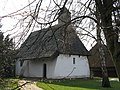
chapel
Also worth seeing is the Protestant chapel Maria Magdalena from 1324.
The hall has a semicircular altar niche and a small belfry over the western part. The hall building has four mighty pillars at the corners of the hall. The roof structure is covered with gray pans and supported on a wooden structure called a knagge. In the northwest, above the entrance door, which dates from the construction period, the roof protrudes far out.
In the small churchyard you can see the remains of a quarry stone wall and some old tombstones from the 19th century. A cannon ball in the outer wall commemorates the battle of Minden in 1759.
There is a service in the chapel every 14 days.

Südhemmern windmill

South Hemmern Mill

Half-timbered building at the Südhemmern windmill
chapel

Passenger ship at the Südhemmern pier
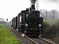
Train of the Mindener Kreisbahnen


Individual evidence
- ↑ Martin Bünermann, Heinz Köstering: The communities and districts after the municipal territorial reform in North Rhine-Westphalia . Deutscher Gemeindeverlag, Cologne 1975, ISBN 3-555-30092-X , p. 116 .
- ^ Friedrich Kochs: The chapel community Südhemmern. Represented on the basis of the chapel accounting book (1651-1800). Communications from the Mindener Geschichtsverein, year 57 (1985), pp. 69–92.
Web links
- Hille community
- Südhemmern in the Westphalia Culture Atlas
Eickhorst | Hartum | Hille | Holzhausen II | Nordhemmern | Oberlübbe | Rothenuffeln | Südhemmern | Unterlübbe