
Werste
|
Werste
City of Bad Oeynhausen
|
|
|---|---|
 |
|
| Height : | 56 m above sea level NN |
| Area : | 6.28 km² |
| Residents : | 6801 (December 31, 2016) |
| Population density : | 1,083 inhabitants / km² |
| Incorporation : | 1st January 1973 |
| Postal code : | 32549 |
| Area code : | 05731 |
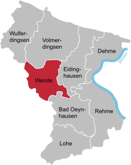  Location of Werste in Bad Oeynhausen
|
|

Werste ( Low German : Weuste ) is a district of the city of Bad Oeynhausen in the Minden-Lübbecke district in East Westphalia .
geography
Werste is south of the Wiehengebirge . In the east Werste borders on the Eidinghausen district , in the north on the Volmerdingsen district , and in the south, separated by the Werre , is the city center of Bad Oeynhausen. In the west the place borders on the city of Löhne in the Herford district .
In the system of natural spatial division of Germany , the Werste area largely belongs to the Ravensberg hill country in the sub-area of the Quernheim hill country. To the south, the west-east running Werre lowland connects with alluvial clay soils. The deepest strip , located directly on the lower Werre , is at risk of flooding and is partially surrounded by dikes . The dike is maintained by the Werre Water Association.
history
In the center of Werste on the south side of Werster Strasse (in front of house number 128) there is an approx. 5000 year old Neolithic stone grave - the only one in the East Westphalia region. It is a reconstruction from 1926 and 1979 using the original boulders . The original grave was undocumented in the 18th and 19th centuries. Century moved and thus destroyed.
The first school was inaugurated in Werste in 1885. In 1930 a new building was built, which is still in use today. After the school reform, the school was continued as a primary school from 1968.
On the occasion of the municipal reorganization , which came into force on January 1, 1973, the previously independent municipality Werste was incorporated into the Rehme district with a total area of around 6.29 km² and 6111 inhabitants in Bad Oeynhausen.
Attractions

In the south of the district (Werster Masch) is the Werre weir. Shortly before, the Werre flows calmly and broadly like a lake. There is a graduation tower in the Sielpark , which is similar to the one in Bad Salzuflen .
Sports
The Turngemeinschaft Werste von 1961 eV and the SV Eidinghausen-Werste eV are the local sports clubs.
Economy and Infrastructure
The Werste industrial park in the west of the district on the border with Löhne covers an area of approx. 34 ha.
The A 30 federal motorway runs through the Werste district as part of the Bad Oeynhausen northern bypass; the next connection points are to the east of Eidinghausen and to the west of the Gohfeld district of Löhn.
Werste is the main location of the Werste-Wulferdingsen primary school network . There are also three kindergartens in Werste.
literature
- Bartling, Gerhard: The stone chamber grave in Werste II. Rediscovery, securing and reconstruction of the lost cultural monument. In: Contributions to the local history of the cities of Löhne and Bad Oeynhausen 5, 1978.
Web links
Individual evidence
- ^ Federal Institute for Regional Studies (ed.): The natural space units on sheet 85 Minden. Edited by Sofie Meisel. (Geographical land survey 1: 200000, natural spatial structure of Germany), Remagen 1959. online
- ↑ Martin Bünermann, Heinz Köstering: The communities and districts after the municipal territorial reform in North Rhine-Westphalia . Deutscher Gemeindeverlag, Cologne 1975, ISBN 3-555-30092-X , p. 115 .
- ↑ Werste industrial park
- ^ Bad Oeynhausen: Schools
- ^ Bad Oeynhausen: Kindergartens