Boelhorst
|
Boelhorst
City of Minden
Coordinates: 52 ° 16 ′ 8 ″ N , 8 ° 52 ′ 42 ″ E
|
|
|---|---|
| Height : | 76 m above sea level NN |
| Area : | 40 ha |
| Residents : | 996 (Dec. 31, 2013) |
| Population density : | 2,490 inhabitants / km² |
| Incorporation : | 1st January 1973 |
| Postal code : | 32429 |
| Area code : | 0571 |
|
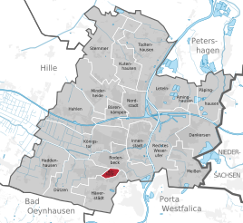
Location of Bölhorst in Minden
|
|
Bölhorst is the smallest district in terms of area of the East Westphalian city of Minden in the Minden-Lübbecke district in North Rhine-Westphalia .
Before the regional reform, Bölhorst was the smallest village in the Minden-Lübbecke district.
history
The place Bölhorst was mentioned for the first time in 1394. On December 31, 2008, the Bölhorst district had 988 inhabitants . This makes Bölhorst the second smallest district of Minden in terms of population and the smallest in terms of area.
The name Bölhorst is to be interpreted as "forest hill" after the field name interpretation. For the Bölhorster, however, this was too easy. The story of the knights von Böl and von Horst, who are said to have had their property on this hill, spurred the imagination on. Thick remnants of the wall were actually found during construction work, which were then immediately estimated at the time of the knights.
On January 1, 1973, Bölhorst was incorporated into the district town of Minden.
The district
The Bölhorst district is the smallest district in Minden in terms of area. This is based on the story of Bölhorst. In contrast to the neighboring villages of that time, there was no farmer in Bölhorst who owned their own arable land. So the size of the village was small. In Minden and the surrounding area, the district of Bölhorst is often called "black Hucken". This was the name of a large overburden mound . This consisted of the remains of the former coal mining, the overburden, and was simply piled up on a field in front of the Bölhorst. The dump was removed in 1952/53 because the overburden at the flood dam was used for the port bridge. Today only one street name (Huckenstrasse) and the restaurant “Zum Hucken” remind of the black Hucken.
politics
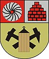
The coat of arms of Bölhorst
The coat of arms consists of three elements that point to the history of Bölhorster.
millstone
The millstone stands in the coat of arms for the Bölhorster mill. This still stands today, but has been converted into a residential building on Klinkerstrasse. In earlier centuries , farmers from all over the area brought their grain to the old windmill , which was owned by the Altendorf family (later Luhmann, then Stolze) for 300 years until it was shut down. At that time, the mill was recognizable from afar due to its geographical location and was therefore a landmark of Bölhorst.
clinker
Up until 1955, bricks were burned on the Bölhorst , which were regionally considered to be particularly hard. A house that was built entirely with these bricks still stands on Lehmhausstraße.
Miner's lamp
Many Boelhorsters earned their living as miners. The old bailiff's name “Between Mountain and Break” specifies precisely what characterizes this landscape. The underlying layers of the chalk formation were the reason for repeated swelling of the ground, of which the Bölhorst, known for its coal mining and brickworks, was the most important. Already in 1668 was in Bölhorst coal in coal mine Bölhorst won their promotion be set in the mid-19th century due Unergiebigkeit had. A new coal mine started production in the Meißen mine in 1876 ; in 1900 it produced around 170,000 quintals of coal and doubled this annual result by 1913. During the war , mining was accelerated again. The third coal mine was the Laura mine in Barkhausen in the Zollern district, but this turned out to be so unproductive that it was shut down again seven years later. This gave work for the miners from Bölhorst and the surrounding area for years. However, the miners had a safe and stable job in the iron ore mines. In addition to the Zeche Viktoria near Lerbeck, this also included the Zeche Dützen-Häverstädt. This was operated at great expense, especially until the Second World War .
Coal and mining
The first coals are said to have been found as early as the Thirty Years War (1618–1648) when Swedish soldiers barricaded in the southern part of the hill .
At the time of Frederick the Great , five mining families came to Bölhorst from the Harz region. The five families were: the Amanns, the Homanns, the Kollmeiers, the Blankenhahns and the Geldmachers, some of which are still represented today. They immigrated as miners from Saxony and the Harz Mountains in the 18th century . Back then, these miners built small adobe houses, some of which are still standing on Lehmhausstrasse today. These characteristic houses had a tiny back garden. The essentials to feed the family were planted in the gardens, because the meager wages were often insufficient to feed the family. They are the oldest houses in the district. With their strange construction, they are almost the only witnesses from the mining era.
In the 19th century, around 150 men mined around 50,000 tons of coal per year in the Laura coal mine with the Bölhorst and Aurora shafts. The Minden-Ravensberger Knappschafts-Verein was also based there.
Bölhorst is crossed by tunnels and struts underground . If you come across pit wood while building a well or if cracks appear in old walls , the Bölhorsters are reminded of the work of their forefathers.
The village bell
The old village bell was melted down in 1942 to make weapons. The inscription on the old bell read:
"Glückauf the whole Bölhorster miners! Drive on, miner!
SGIRNMBF Friedrich Rinckert from Osnabrück cast me in 1775. "
For the 1950 harvest festival , the Bölhorst received a new bell with the inscription “When I sound, remember your sons who gave blood and life for you.
Re-donated by the municipality of Bölhorst in 1950. "
On the lower edge it says (as a reminder): “Glückauf the whole Bölhorster Knappschaft! Drive on, miner! "
Individual evidence
- ↑ Population statistics of the city of Minden ( Memento from April 28, 2015 in the Internet Archive ) accessed October 13, 2014.
- ^ Federal Statistical Office (ed.): Historical municipality directory for the Federal Republic of Germany. Name, border and key number changes in municipalities, counties and administrative districts from May 27, 1970 to December 31, 1982 . W. Kohlhammer, Stuttgart / Mainz 1983, ISBN 3-17-003263-1 , p. 326 .
- ^ Gregor Gehrke: Mining in Minden-Ravensberg. From a report by the miner Brassert from 1862 on mining in the administrative district of Minden. Communications of the Mindener Geschichtsverein, year 62 (1990), pp. 163–170.
Web links
- Bölhorst in the network
- Bölhorst in the Westphalia Culture Atlas


