
Soul field
|
Soul field
City of Petershagen
Coordinates: 52 ° 26 ′ 7 ″ N , 9 ° 4 ′ 10 ″ E
|
|
|---|---|
| Height : | 61 m above sea level NN |
| Area : | 4.53 km² |
| Residents : | 303 (Oct. 1, 2010) |
| Population density : | 67 inhabitants / km² |
| Incorporation : | 1st January 1973 |
| Postal code : | 32469 |
| Area code : | 05705 |
 Location of Seelenfeld in Petershagen
|
|
_IMG_9708.jpg)
Seelenfeld is a district of Petershagen in the northeast of the Minden-Lübbecke district in East Westphalia .
geography
It is 9 km northeast of the city center; to the east, Seelenfeld borders the town of Rehburg-Loccum in the district of Nienburg / Weser , Lower Saxony , to the north to the districts of Heimsen and Ilvese , to the west to the district of Döhren and to the south to the district of Neuenknick . On October 1, 2010, Seelenfeld had 303 residents.
history
The town of Seelenfeld was first mentioned in 1282 in a document from the councilors of Hameln , according to which Heinrich Seelenfeld had sold his property in Seelenfeld to the Loccum monastery with the full consent of his family .
Until the municipal reorganization on January 1, 1973, Seelenfeld was an independent municipality with a total area of around. 4.53 km² and 348 inhabitants (31 December 1972) and belonged to the Office Windheim to Lahde in Minden .

Nature reserve Sandgrube Seelenfeld

Old school
_IMG_9959.jpg)
_IMG_9974.jpg)
politics
The population of Seelenfeld has been represented to the council and administration of the city of Petershagen since 1973 by a local mayor who is elected by the council of the city of Petershagen on the basis of the election results.
The local mayor is Jürgen Buschke (CDU).
Culture and sights
- The old school was at its inauguration in 1912, the landmark of soul field and with its bell tower today a highly visible, impressive building. School operations ceased in 1965 and the building is privately owned.
- The Königsmühle Seelenfeld stands on the highest elevation (74 m above sea level) of the old Seelenfeld farmers. The stone tablet with the carved inscription FWR 1731 can be seen above the narrow entrance door of the mill . FWR are the first letters of the words Fridericus Wilhelmus Rex. The King of Prussia had this mill built. Seelenfeld is part of the Westphalian Mühlenstraße and is on the Mühlenroute .
- The nature reserve Sandgrube Seelenfeld is near the village. The properties of the large sandy areas with their extreme drought and lack of nutrients are suitable for developing special habitats for warmth-loving animal and plant species.
- The war memorial from 1920 in Seelenfeld commemorates the fallen of the First World War.
- The boulder from the local sand pit is a granite block and commemorates the 700th anniversary of Seelenfeld in 1982.
- Dat Dorphus from 1670 was inaugurated in 1995 after renovations by the villagers themselves for use by the village community.

Dat Dorphus

Memorial stone 700 years
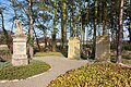
War memorial
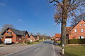
Town view
_IMG_9938.jpg)
_IMG_9944.jpg)
_IMG_9947.jpg)
_IMG_9943.jpg)
Economy and Infrastructure
To the west of the nature reserve Sandgrube Seelenfeld and south of the village is the Seelenfeld sand-lime brick plant.
Seelenfeld is crossed by Loccumer Straße, which connects the place with Loccum and with the federal highway 482 .
Web links
Individual evidence
- ↑ Erhard Saecker: On the settlement history of the village of Seelenfeld. A contribution to the 700th anniversary. Communications from the Mindener Geschichtsverein, year 54 (1982), pp. 125-138.
- ↑ Martin Bünermann, Heinz Köstering: The communities and districts after the municipal territorial reform in North Rhine-Westphalia . Deutscher Gemeindeverlag, Cologne 1975, ISBN 3-555-30092-X , p. 118 .

Bierde | Buchholz | Döhren | Eldagsen | Friedewalde | Frille | Gorspen-Vahlsen | Grossenheerse | Hävern | Heimsen | Ilse | Ilserheide | Ilvese | Jössen | Lahde | Maaslingen | Messlingen | New kink | Ovenstädt | Petershagen | Quetzel | Raderhorst | Rosenhagen | Shlisselburg | Soul field | Südfelde | Waterway | Wietersheim | Windheim