Dornberg Office
| coat of arms | Germany map | |
|---|---|---|
 Help on coat of arms |
Coordinates: 52 ° 3 ' N , 8 ° 28' E |
|
| Basic data (as of 1972) | ||
| Existing period: | 1843-1972 | |
| State : | North Rhine-Westphalia | |
| Administrative region : | Detmold | |
| Circle : | Bielefeld | |
| Area : | 23.95 km 2 | |
| Residents: | 8971 (Dec. 31, 1966) | |
| Population density : | 375 inhabitants per km 2 | |
| Office structure: | 5 municipalities | |
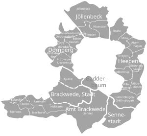
| Location of the Dornberg office in the Bielefeld district | ||
The Dornberg office was an office in the Bielefeld district in North Rhine-Westphalia . It existed since 1843 and was dissolved on December 31, 1972. Its former communities are now part of the Dornberg district of Bielefeld .
history
The area of the later office belonged to the Vogtei Brackwede until the end of the 17th century and then came under the administration of Werther in the office Sparrenberg of the County of Ravensberg . The official business was temporarily taken over by the Vogt in Schildesche at the end of the 18th century .
During the French occupation, the Dornberg area belonged to the canton of Werther in the Bielefeld district of the Kingdom of Westphalia from 1807 . In 1811 the areas northwest of a line Aa - Johannisbach - Schwarzbach were separated from the Kingdom of Westphalia and France was incorporated. Most of the Dornberg area was separated from the canton of Werther and incorporated into the canton of Schildesche in the Bielefeld district. After the end of the French occupation, the Dornberg area became part of the newly formed Bielefeld district in 1816 . In 1817 Deppendorf was reclassified from the Halle district to the Bielefeld district.
The Dornberg area continued to exist in the Bielefeld district as an administrative district, which was referred to as the Dornberg community and remained subordinate to the Schildesche mayor . As part of the new Prussian rural community order for the province of Westphalia , Dornberg was raised to an office in the Bielefeld district on December 30, 1843. In 1845 five communities were finally constituted:
In 1930 there was a municipal reorganization in the Bielefeld area. A part of Gellershagen fell to Babenhausen. The Wellensiek housing estate developed in Großdornberg and part of Hoberge-Uerentrup in the Wolfskuhle area were incorporated into Bielefeld. In 1961 the residential area called Babenhausen-West on Dürerstrasse was reclassified from Babenhausen to the city of Bielefeld.
By the law on the reorganization of the Bielefeld area on December 31, 1972 the five municipalities of the Dornberg office were incorporated into Bielefeld and the office was dissolved. Legal successor to the office was the enlarged city of Bielefeld. The five municipalities of the office today belong to the Dornberg district of Bielefeld.
Population development
| year | Residents |
|---|---|
| 1843 | 3,393 |
| 1864 | 3.226 |
| 1910 | 3,178 |
| 1925 | 3,279 |
| 1939 | 4,408 |
| 1949 | 6,498 |
| 1966 | 8,971 |
Church affiliation
The places of the Dornberg office formed the Evangelical parish of Dornberg in the 19th century . The Peterskirche in Kirchdornberg was the parish church of the parish.
Web links
Individual evidence
- ^ Territorial division of the Bielefeld district . In: Law Bülletin of the Kingdom of Westphalia Volume 2 . November 20, 1812, p. 423 ff . ( Digitized online [accessed April 13, 2010]).
- ^ Rolf Jehke: Territorial changes in Germany. Retrieved April 22, 2010 .
- ^ Alfred Bruns (ed.): Westfalenlexikon 1832-1835 . (Reprints for the Westphalian archive maintenance). Westphalian State Office for Archive Maintenance, Münster 1978.
- ^ Map of Bielefeld with neighboring communities. In: Online map service of the city of Bielefeld. 1827, Retrieved April 14, 2010 .
- ↑ Information on the historical map from 1827; Paragraph administrative division. Land surveying and land registry office of the city of Bielefeld, 2005, accessed on April 14, 2010 .
- ↑ Regulation No. 46 . In: Official Journal of the Minden Government . January 10, 1844, p. 21 ( digitized online [accessed April 22, 2010]).
- ^ Parish division of the Dornberg district. In: Official Journal of the Minden Government. September 8, 1845, accessed April 22, 2010 .
- ^ Law on the expansion of the Bielefeld district. (PDF; 7 kB) In: Collection of laws for the Royal Prussian States. June 11, 1930, p. § 1 , accessed April 14, 2010 .
- ↑ a b Seemann: Geographical-statistical-topographical overview of the administrative district of Minden. (PDF; 802 kB) 1845, pp. 52-57 , accessed on April 23, 2010 .
- ↑ Topographical-statistical manual of the government district of Minden . 1866, p. 10 ( digitized online [accessed April 22, 2010]).
- ^ Uli Schubert: German community register 1910. Accessed on May 22, 2009 .
- ^ A b Michael Rademacher: German administrative history from the unification of the empire in 1871 to the reunification in 1990. bielefeld.html. (Online material for the dissertation, Osnabrück 2006).
- ^ Gustav Engel: The city and district of Bielefeld . In: District and city handbooks of the Westphalian Heimatbund . Regensberg, Münster 1950.
- ^ Bielefeld district (ed.): 150 years Bielefeld district . 1966, p. 60 .


