Bielefelder Pass
| Bielefelder Pass | |||
|---|---|---|---|
|
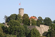
Bielefelder Pass seen from the Sparrenburg |
|||
| Pass height | 120 m above sea level NHN | ||
| region | Bielefeld | ||
| expansion | B 61 / railway | ||
| Mountains | Teutoburg Forest | ||
| map | |||
|
|
|||
| Coordinates | 52 ° 0 '30 " N , 8 ° 30' 40" E | ||
The Bielefelder Pass is a 2.5 km long transverse valley of the Teutoburg Forest , which is only 120 m above sea level. NHN The height of the apex is the deepest cut of this ridge (measured against the foreland) . As the passage of important traffic routes such as the main line of the Cologne-Mindener Eisenbahn-Gesellschaft built in the 1840s , it contributed to Bielefeld developing into what is now the third largest city in Westphalia .
geography
The Bielefelder Pass connects the Ravensberg hill country in the northeast, which is about 90 to 120 meters high for three kilometers, with the Münster lowland bay , which drops from an average of 140 meters at the foot of the mountains to 100 meters at a distance of three to four kilometers. The valley floor is highest near the southern exit. From the Lutter , which rises here and naturally flows to the Ems , water has been diverted to the northeast since the Middle Ages.
The south-eastern boundary is formed from north to south by the Sparrenberg with the Sparrenburg , the Zionsberg with the church of the v. Bodelschwinghschen Anstalten , popularly known as Bethel , and at the Brackweder end the 213 m high Lönkert . From the wide valley basin between Zionsberg and Lönkert comes the Bohnenbach , the original water of (old) Bielefeld, which unites in the valley floor of the pass with the artificial eastern course of the Lutter . The north-western boundary is formed by the 200 m high Johannisberg , the 248 m high Kahle Berg and the 220, at the end of the ridge still 212 m high Blömkeberg .
Usage history
In the Middle Ages, customs were levied on the road through the pass; the customs barrier was near today's Betheleck and gave the village and today's district of Gadderbaum its name. To the southwest of the barrier, the paths branched out in a fan shape, with the country road leading to Halle (Westf.) Running down the valley over the 210 m above sea level. NHN high saddle between Blömkeberg and Jostberg left. The monastery, which was later moved to Bielefeld, was located on this saddle (see St. Jodokus Monastery Church ). This loop road , which today is no longer a traffic route and can only be driven on with mountain bikes, owes its name to the "loop", restricted passages through several landweists , with which the access to the Bielefelder Pass was secured. A remnant of the southern part of the path fan is the Lönkert street in Brackwede.
In the 19th century, the old, unpaved country roads were replaced by dead straight roads , which later became federal roads , in the pass the Artur-Ladebeck-Straße (until the construction of the Ostwestfalendamm B 61 ) along the southeastern edge of the valley. Of greater importance for long-distance traffic was the construction of the main line of the Cologne-Mindener Eisenbahn-Gesellschaft , completed in 1847 ; the Hamm – Minden railway is part of the connection from Paris to Moscow . As part of this railway line, the Brackwede freight station was built in the (gradient-free) apex area of the valley floor. The remainder of the valley floor to the northeast, where the Bielefelder Bleichen had previously been located, also became an industrial area. Nowadays it is mainly the premises of the Bielefeld food producer Dr. Oetker , which also owns the Vorwärts spinning mill , one of the first large factories in Bielefeld. In the 1970s, on the partly steep slope northwest of the railway, Carl-Severing-Straße was replaced by the freeway-like Ostwestfalendamm , today's B 61.
In the 1950s and 1960s, on the slope of the Blömkeberg above this route in Bielefeld, there was the municipal rubbish dump , which contaminated the groundwater and was at risk of landslide .
Web links
Remarks
- ↑ However, the path is already marked as a “narrow, stony passage” in a map of the Bielefeld area drawn up for Frederick the Great .


