
Deister
| Deister / Great Deister | |
|---|---|
 The Deister with Calenberger Land , Süntel and Kleinem Deister |
|
| Highest peak | Bröhn ( 405 m above sea level ) |
| location | Districts of Schaumburg and Hameln-Pyrmont as well as the Hanover region ; Lower Saxony ( Germany ) |
| Lower Saxony highlands | Calenberg mountains |
| Coordinates | 52 ° 15 ′ N , 9 ° 31 ′ E |
| rock | Limestone , marl , sandstone |


The Deister , also called Großer Deister , is a maximum of 405 m above sea level. NHN high ridge in the Calenberger Bergland on the northern border of the Lower Saxon mountainous region near Hanover in the districts of Schaumburg , Hameln-Pyrmont and the Hanover region . Although it is often seen as part of the Weser Uplands , it does not belong in the narrower sense.
geography
location
The Deister is located around 20 km southwest of Hanover . It stretches between the towns of Bad Nenndorf in the northwest, Barsinghausen in the north, Wennigsen in the northeast, Bennigsen in the east, Springe in the southeast, Bad Münder in the south, Eimbeckhausen in the southwest and Lauenau in the west over a length of about 21 km; its width averages four kilometers. The mountain range of the Kleiner Deister joins in to the southeast .
Numerous streams spring from the Deister. It is drained over the Rodenberger Aue , Südaue , Ihme and Haller into the Leine , in the Bad Münder area over the Hamel to the Weser .
Natural structure
The Deister consists in the natural spatial main unit group Weser-Leine-Bergland (No. 37), in the main unit Calenberger Bergland (378) and in the subunit South-Hannoversche Berge (378.3) from the natural areas Barsinghausen Deister (378.30; northeast) and Nienstedter Deister (378.31; southwest).
mountains
The Deisterkamm is up to 405 m high and is crossed roughly in the middle of the 276.6 m high Nienstedter Pass . The mountains and elevations of the ridge include - sorted by height in meters (m) above mean sea level, unless otherwise stated:
- Bröhn (405 m), between Nettelrede and Wennigser Mark - with Annaturm ( AT )
- Deer Heads : west north-west knoll (395 m) and east south-east knoll (390 m), between Springe and Wennigser Mark
- Höfeler (395 m), between Luttringhausen and Wennigser Mark - with air traffic control system
- Reinekensiekskopf (382 m), northeast of Nienstedt - with Nordmannsturm and nearby Teufelskanzel
- Hohe Warte (379 m), east of Nienstedt, between Wennigser Mark and Eimbeckhausen
- Fahrbrink (376 m), northwest of Springe
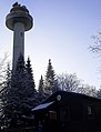
- Großer Hals (361 m), between Barsinghausen and Lauenau - with a telecommunications tower
- Ebersberg (355 m), west of Springe
- Egge (355 m), between Barsinghausen and Lauenau
- Bielstein (344 m), between Springe and Wennigsen - with cliffs and a refuge
- Rodenberger Höhe (330 m), between Hohenbostel and Lauenau - with Wallburg Heisterburg ( KD ) and transmission tower
- Stiegeskopf (325 m), between Springe and Wennigsen
- Kalenberg (310 m), between Bredenbeck , Springe and Völksen
- Kappenberg (203.3 m), between Altenhagen II and Springe
- Strutzberg (198 m), southwest of Bantorf - with Belvedereturm (AT)
Localities
Nienstedt is the only larger town in the Deister. At its edges lie:
geology
The Deister has a Herzynisch pronounced strike direction. It forms the northeast wing of a large saddle structure . A latch equal to the densely wooded ridge to the southeast, Kleiner Deister and separates Osterwaldstraße the flat Calenberger Lössbörde of the settlement chambers of Ith , the Süntel and Bückeberge from. The mountains were created by uplifts as part of the Saxon flood tectonics , while the surface was formed during the Elster and Saale glaciers.
The north-easterly roofing half of the Deister is characterized by outcropping sandstones , siltstones and claystones , some with the inclusion of coal . They are the so-called Upper Church layers ( Wealden ) of the Lower Cretaceous . The morphologically somewhat steeper half, facing south-west, is characterized by outcropping marl stones , clay stones and limestones . They are the so-called Münder marls of the Upper Jurassic . Limestone, the so-called "Eimbeckhäuser Plattenkalk", adjoins it further to the southwest.
Deister sandstone was mined from the Middle Ages to modern times and used for building purposes.
nature
Protected areas
The North Deister landscape protection area ( CDDA no. 323262; designated in 1994; 55.99 km² ) is located on the areas of the Deister to the north-east of its main ridge , and the three-part LSG Süddeister (CDDA no. 324902-4 ; 1967; 75.6 km²). The fauna-flora-habitat area Süntel, Weser Mountains, Deister (FFH no. 3720-301; 24.97 km²), which is designated as a nature reserve Köllnischfeld in the Hanover region, extends southwest of this ridge .
Flora and fauna
The mountain range is covered by a beech - spruce -, partly also beech and oak forest or mixed forest. At the Cecilienhöhe near Bad Nenndorf , at the Lauenau -Feggendorf barbecue area and southwest of the former Köllnischfeld forester's lodge , there are still several specimens of the rare, indigenous Süntel beeches .
The rare plants of the Deister also include pods (holly), daphne , orchids , lobed shield fern and large snowdrop .
The Deister is home to a fauna typical of the German low mountain range. Red , roe deer and wild boar are found numerous. Other hairy game species that occur are tree and stone marten , ermine , polecat and weasel as well as the fox . It is now also home to bio-invaders such as raccoons and raccoon dogs . It is home to the birds of prey, buzzard , goshawk and red kite . Of the rarer small animals, the bat species mouse- eared and lesser horseshoe bat make their home here.
forestry
The state forest districts in Deister, together with those in Kleiner Deister, belong to the Saupark forestry office in Lower Saxony, based in the Springe hunting lodge, and are divided into the forest districts of Brünninghausen, Georgsplatz, Jägerhaus, Köllnischfeld, Lauenau and Osterwald. The Barsinghausen and Wennigsen monastery forests belong to the Wülfinghausen monastery district forester. There are also private forests such as the Knigge Forest near Bredenbeck.
Attractions
The Deister lies in the border area of old Germanic Gaue , medieval sovereign territories and modern rural districts . Therefore, numerous historical places can be found in the ridge, which are often hiking destinations:
- Around 200 prehistoric barrows , mainly in Rehborn and in Schneegrund
- Ancient baptism stone formation
- Numerous old landmarks and memorial stones
- Old quarries in which Deistersandstein used to be mined
- Remains of the hard coal mining in the Deister , including the Feggendorfer adit
- Remains of early medieval ramparts :
- Heisterburg near Lauenau - Feggendorf
- Wirkesburg near Lauenau-Feggendorf
- Bennigser Castle near Bennigsen
- Wennigser water wheels on the Bruchbach near Wennigsen
- The Devil's Bridge (near Rodenberg)
- Visitor mine Klosterstollen in Barsinghausen
- Towers in the Deister

Natural monument "Old Baptism"

Information board "Great Deister recreation area"

Visitor mine Klosterstollen am Deister


Towers
There are several towers on the Deister (selection):
- Annaturm (29 m), observation tower on the Bröhn , with forest restaurant Annaturm
- Belvedereturm , observation tower on the Strutzberg , built in 1852, raised in 1987
- Barsinghausen telecommunications tower (139 m, 150 m with antenna), built on the Großer Hals , 1967–1969.
- Nordmannsturm (19 m), observation tower on the Reinekensiekskopf , built in 1862/63 by the Hanoverian mason and stone mason Constantin Nordmann (1805-1889), destroyed by lightning in 1881, rebuilt in 1882, renovated in 2000 - access through the Nordmannsturm restaurant
Annaturm
(with restaurant)
View from Annaturm on the Deister over Wennigsen north-east to the Calenberger Land

Belvedere tower

Nordmannsturm
(with restaurant)


- Radar station of the German Air Traffic Control (DFS) on the Höfeler : One of six SRE-M systems nationwide : Platform 26 m high / with antenna 38.5 m, built as a concrete tower in 1981/82 (replacement for an old steel grid construction). The range is around 145 nautical miles (NM), which corresponds to 270 km.


Sports
Cycling:
The Deister is criss-crossed by numerous farm roads that are often used by mountain bike riders. The main paths are also passable with trekking bikes . The Nienstedter Pass is very popular with racing cyclists, as it is the only way over the Deister that is suitable for racing bikes. The steepest road-like driveway to the Deisterkamm is the Jägerallee that begins in Springe and has a maximum gradient of 15 percent. However , it is not possible to cross the Deister on a paved route here.
Winter sports: There are three ski lifts in
Deister bei Springe . In addition, cross-country skiing trails are set up at Köllnischfeld when the weather permits. These systems are operated by the Ski Club Springe e. V. maintained.
Gliding:
With south-south-west winds , lee waves form on the Deister , in which gliders can soar to great heights in laminar updraft . Heights of a maximum of 7000 m have already been flown without engine power.
Phrase
The saying "he is over the Deister" can stand for "disappeared", but also "deceased": In northern German usage the expression "go over the Deister" is used like "go down the stream", "make yourself out of the dust" or “to go across the Jordan ”.
One would like to “send over the Deister” a person with whom one no longer wants to have anything to do so that he finally disappears.
The expression probably originated from the migration of many young people from the Schaumburger Land, located southwest of Deister, to the growing city of Hanover in the 19th and early 20th centuries: This is located “over Deister” on the northeast side of the ridge. Conversely, it was customary for highly indebted Hanoverians to flee "over the Deister" to the Grafschaft Schaumburg in order to escape their creditors. Another theory from the tourism sector assumes that the phrase originated through human sacrifice at the Old Baptism . However, it is historically controversial whether human sacrifices actually took place on the stone.
Another theory can be traced back to the village of Nienstedt in the Deister. The areas of the Nienstedt district were cleared by monks from the Barsinghausen monastery between around 1200 and 1700 . The Nienstedter have therefore always belonged to Barsinghausen ecclesiastically, but did not have their own cemetery for decades or even centuries. So the deceased had to be laboriously brought "over the Deister" to the funeral.
Traffic and walking
The federal road 217 ( Springe - Völksen - Steinkrug ) runs through the eastern foothills of the Deister near Völksen and the federal road 442 ( Bad Münder - Eimbeckhausen - Messenkamp - Lauenau - Rodenberg - Bad Nenndorf ) with a connection to the western federal motorway 2 ( Lauenau junction ). The state road 391 (Bad Nenndorf - Hohenbostel - Barsinghausen - Egestorf - Wennigser Mark - Wennigsen ) leads past it to the north , to which the L 390 (Wennigsen - Argestorf - Bredenbeck - Bennigsen ) connects to the east . So you can bypass the Deister entirely. About the middle of the Deister leads from Egestorf in the northeast over the Nienstedter Pass ( 276.6 m ) and through Nienstedt to Eimbeckhausen in the southwest, the L 401, and between Nienstedt and Messenkamp, the district road 61 runs through the southwest foothills of the ridge.
For example, starting at these roads, the Deister can be hiked on forest paths and paths. His hiking trails include:
- European long-distance hiking trail E1 , runs from Bad Nenndorf largely on the ridge path through the Deister to Bad Münder am Deister
- Calenberger Weg (Bad Nenndorf-Marienburg), runs from Bad Nenndorf first on the north side, crosses the Deister at the Taternpfahl and leaves it in Völksen
- Roswithaweg (Nienburg-Bad Gandersheim), runs on the south side
- Kansteinweg (Hannover-Alfeld), crosses the Deister on the Wöltjebuche
- Deisterkreisel, cycle route that leads around the Great Deister
literature
- Natural History Society Hanover (ed.): The Deister - Nature • Human • History. (= Naturhistorica. Reports of the Natural History Society Hanover. Volume 131). zu Klampen Verlag, Springe 2017, ISBN 978-3-86674-545-2 .
- Peter Meyer, Katja Lorenz, Andreas Mölder, Roland Steffens, Wolfgang Schmidt, Thomas Kompa, Anne Wevell von Krüger: Natural Forests in Lower Saxony. Protection and Research. Volume 2 - Lower Saxony mountains . Leinebergland-Druck, Alfeld 2015, ISBN 978-3-00-050091-6 .
- Udo Mierau: Out and about in the Deister-Süntel valley. Fürsten Mirski-Verlag - Udo Mierau, Springe 2000, ISBN 3-00-006589-X .
- Günther Klapproth: memorial stones in the Deister. Cadmos-Verlag, Schwarzenbek 2003, ISBN 3-7842-0664-6 .
- Horst Krenzel: Memories of the hard coal mining in the Deister Mountains. Geiger-Verlag, Horb 1999, ISBN 3-89570-195-5 .
- Ralf Orlowski: The Deister. Photo book. 2007, ISBN 978-3-00-022586-4 .
Individual evidence
- ↑ a b c d e f g h i Map services of the Federal Agency for Nature Conservation ( information )
- ↑ a b c d e f g Topographic map with the Deister ( Memento of the original from February 25, 2016 in the Internet Archive ) Info: The archive link was inserted automatically and has not yet been checked. Please check the original and archive link according to the instructions and then remove this notice. (Heights according to magnification levels DTK50 – AK2.5), on natur-erleben.niedersachsen.de
- ↑ The Deister - a portrait. In: www.deister.de. Retrieved May 20, 2020 .
- ↑ Monastery Forests. (No longer available online.) Hanover Monastery Chamber, archived from the original on December 22, 2015 ; Retrieved December 19, 2015 . Info: The archive link was inserted automatically and has not yet been checked. Please check the original and archive link according to the instructions and then remove this notice.
- ↑ Leewellen in the north German low mountain range , on Mittelgebirgsleewelle.de
Web links
- Website for the Deister , on deister.de
- The Deisterkreisel… (bike path), on deisterkreisel.de
- The Deisterkreisel , tour description with GPS track, on tourismusregion-hannover.de
- Deisterbergbau (Former coal mining in the Deister), on schatzsucher.de
- Deister Fun - The excursion magazine (excursion destinations in Deister), on deister-spass.de