
Heisterburg
| Heisterburg | ||
|---|---|---|
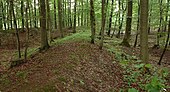
 The northwestern gate of the Heisterburg, excavated around 1930 (2007) |
||
| Alternative name (s): | Hoyer, Hoysburg, Hoiesburg | |
| Creation time : | around 900 to 1200 | |
| Castle type : | Hilltop castle | |
| Conservation status: | Remnants of walls, walls, ditches | |
| Place: | Rodenberg & Bad Nenndorf | |
| Geographical location | 52 ° 17 '46.8 " N , 9 ° 24' 19.5" E | |
|
||

The Heisterburg in Deister was a hill fort from the 10th to 11th centuries near the Lauenau district of Feggendorf . Half of it lies in the area of the joint municipality of Nenndorf and half of the city of Rodenberg in Lower Saxony .
location
The facility is located in a wooded area at the north-western end of the Deister. It is located near the ridge at about 330 meters above sea level in a depression between two flat elevations. The fort is located on the former border between the medieval districts Bukkigau and Marstemgau . Today it lies on the border between the city of Rodenberg and the joint municipality of Bad Nenndorf and the border between the Hanover region and the Schaumburg district .
Surname
A written record of the Heisterburg or a mention in historical documents is not known. In 1875 a local researcher and pastor from Barsinghausen - Hohenbostel published his research on the origin of the name of the Heisterburg. According to this, the complex was still called Hoyer, Hoysburg or Hoiesburg in the 16th century. In old land maps the area is called hoiser Burch in 1574, Hoisburg in 1651 and Heuser Burg in 1840. The root word Hoyer is derived from the old word hoye for guardianship . It is synonymous with the usual in other places name waiting for such plants. Hoysburg therefore has the meaning of a guardian castle located in an elevated position, from which the surrounding area can be overlooked and monitored. According to another interpretation, the term Heister came into the name of the ramparts because of its location in a young beech forest .
description


The Heisterburg consists of a smaller, 0.9 hectare main castle and a spacious 7.4 hectare outer bailey . The main castle results from an almost square ring wall in the form of a square hill of 106 or 115 × 107 or 111 meters. The two earlier access gates are designed as pincer gates . They are located on the northwest corner and in the eastern wall in the southeast area. At the north-western gate, the ramparts, which have been preserved at a height of one meter, are curved inwards, where they narrow to the gate with a width of 2.6 m. The southeast gate also narrowed inward. Both gate areas were paved.
The current state of preservation of the ramparts can be described as good, as there have been no erosion or other major changes over time. The wall is still 2 m high and about 10 m wide today. The outer front of the wall consisted of a mortar wall, 1.70 m thick and probably several meters high, of which there are still remains below ground at a height of 1.5 m. After the end of use of the facility, the above-ground stones of the wall were probably removed for building projects in the nearby villages or for the construction of other fortifications such as the Lauenau moated castle and the Rodenberg moated castle . In front of the outside was a pointed ditch , in places marked as a bottom ditch, with an original depth of approx. 2.50 m and approx. 8 m width. In the southwest corner of the main castle were foundations identified as modern , which could have been the substructure of a wooden tower.
The excavations in the interior of the main castle unearthed two approximately 5.5 m deep shafts, which are interpreted as wells or cisterns . In a depression in the ground, shards and bones were found up to 4 meters deep. The foundations of five one-room buildings with a size of up to 5 × 10 meters, which had a basement, and other unexplained walls were also discovered. In the north of the main castle more than 20 stone packings were found during excavations in 1930, which can be interpreted as ovens or stoves. Slag , iron ore and horseshoes were found in this area . This suggests iron smelting and forging activities. In the outer bailey a sunk six-post pit house with a hearth and ceramic remains from the 10th century was discovered.
The outer bailey adjoins to the north and borders a stream with its ramparts. It is characterized in the east by a 500-meter-long wall, which at the bottom had a seven-meter-wide pincer gate , where the walls were stiffened with walls. In the west a 100 m long wall protected it. 400 m north of the outer bailey is a rampart with a ditch. In contrast to the main castle, there are no walls in the ramparts. There are also several ramparts to the east and west of the core plant and in the wider area. It could be ramparts, section ramparts or components of the younger Bückethaler Landwehr .
In 2011, the district of Schaumburg and the Lower Saxony State Forests put up prohibition signs on the ramparts of the castle, prohibiting excavation activities and mountain biking . It was observed that the ramparts of the historical complex served as an obstacle course and were redesigned for this purpose.

Overall plan of the Heisterburg with outer bailey and ramparts from 1885

Section through the wall, 1892

Plan of the main castle, 1892

Ground plan of the south-eastern gate of the main castle, 1892


archeology
Old excavations
There were excavations on the site of the Wallburg in 1887, 1891–92 and 1929–32. The first excavation was carried out in Bad Nenndorf in 1887. In July 1891 a baron of the Wichtringhausen manor carried out an excavation with 15 workers. The stone wall within the ramparts in the area of the main castle was exposed. A gate was also excavated in the northwest of the main castle. In October 1891, the Hanoverian archaeologist Carl Schuchhardt had the excavation continue with 10 to 15 workers, most of whom were miners . The following year, in July and September 1892, they were continued with four workers. Around 1930 the archaeologist Hermann Hofmeister mainly carried out excavations on the site of the spacious outer bailey.
The excavations unearthed various finds, such as nails, remains of ceramic vessels, horseshoes and remains of bones. A larger and a smaller spherical pot , which are exhibited in the Rinteln Museum, were reconstructed from broken pieces .
Prospecting 2014-2017

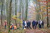
In autumn 2014, the municipal archeology department of the Schaumburg landscape under the direction of the archaeologist Jens Berthold had geophysical prospecting carried out throughout the main castle and a smaller area of the outer castle . The project, worth 10,000 euros, enabled the non-destructive x-raying of the subsurface to identify the remains of the Heisterburg. During the six-day investigations by a prospecting company and volunteers, investigations were carried out using a magnetometer and ground penetrating radar . While there were hardly any earlier areas of activity in the outer bailey, anomalies were found in the main bailey, which indicate manual processes with heat effects. Smelting furnaces and slag residues are possible causes . There was also evidence of settlement pits . At the highest point of the main castle, the ground penetrating radar showed an area of 20 × 30 meters with rectangular structures, which indicates a stone building. It is a complex of several buildings or rooms that were partially uncovered during earlier excavations. The investigations served as a well-founded inventory of the plant. The test results were presented to the public in Rodenberg in 2015 .
In 2017, geospatial students at the Institute for Cartography and Geoinformatics at the University of Hanover carried out a relief mapping of the fortifications. Such measurements of archaeologically significant systems for the production of a virtual 3D model have been taking place for decades in cooperation between the University of Hanover and the Lower Saxony State Office for Monument Preservation .

Northwestern gate with information board
Northeastern Wallecke, left main castle, right outer castle area
Geophysical prospecting in autumn 2014
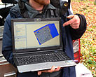
Ground penetrating radar image of a part of the Heisterburg, 2014


New excavation 2018
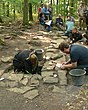
In 2018, students from the HAWK Hildesheim carried out an excavation under the direction of archaeologist Markus Blaich from the Lower Saxony State Office for Monument Preservation. It took place in cooperation with the municipal archeology of the Schaumburg landscape. The teaching and research excavation was carried out in four small-scale excavation areas and was used in particular to date the fortifications using the remains in the ground. It led to the determination of various findings , such as 50 cm wide foundations with several layers of stone, a waste pit filled with stones and possible remains of a stove or a fireplace. The archaeologists suspect that the foundations are the threshold beam construction of a building. Apart from individual ceramic and bone remnants, only a few finds were brought to light. According to the archaeologists, one explanation for the extraordinary scarcity of finds could be the short period of use of the fortifications. As a result of the two-week excavation, individual building floor plans within the main castle could be reconstructed. After the excavation work was completed, the investigated areas were covered with earth again to protect them.

Excavation title
Exposed remains of the foundation, 2018
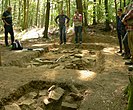
An excavation area

Photographic documentation


Interpretation of use

The earlier as well as the more recent archaeological investigations could not provide any unequivocal information about the time of origin. The finds, in particular the found pottery from the 10th century, led to the assumption that the facility was mainly used in the 11th century. In the written tradition there is no information about the builders or users of the Heisterburg, so that its history is still unclear despite the previous investigations. A closer exploration, which was carried out between 2014 and 2018 through prospecting and an excavation, had long been a research desideratum , also with regard to a connection with the Billunger possessions in the nearby Deister-Süntel Valley .
There are different theories and explanations about the purpose of the system. Because of the stone buildings that were found, it could have been the seat of a noble family before the presence of the Schaumburg counts . A border point on a trade route is also conceivable . Because of the smelting remains, the plant could be related to the Deister mining . The only thing that seems certain is that because of the strong fortifications and the permanent presence of people, it was a military and political central place in the manner of a fortified hilltop settlement . In the case of the Heisterburg, early and high medieval activity zones with remains of buildings contradict the theory of a Fliehburg in the main castle. However, the remains of the building could also be later installations in an earlier system. Due to the low level of activity, the extensive area of the outer bailey appears more like a refuge, in which the population could stay briefly in times of war or danger.
Similar fortifications in the vicinity
There are ramparts similar to the Heisterburg in and around the Deister; the next is the Wirkesburg near Lauenau -Feggendorf, just 600 meters south . All of these systems were probably built between the 9th and 11th centuries, which could be proven in some cases by means of the 14 C dating .
- In the plane:
- Isenburg near Barsinghausen -Landringhausen
- Düsselburg near Rehburg
- Lüningsburg near Neustadt am Rübenberge
- In height:
- Barenburg near Eldagsen
- Heisterschlösschen near Beckedorf
- Kukesburg near Springe - Altenhagen I
- Bennigser Castle near Bredenbeck- Steinkrug
- Sachsenwall near Nordstemmen
- Ring wall on the Gehrdener Berg near Gehrden
Fortifications of this kind were originally regarded as Saxon or Heinrichsburgen by archaeological research . The more recent research assigns the structures in the area of the Central Weser and the Leine to a period from the 8th to the 12th century. Due to the lack of settlement, the facilities are likely to have only been used sporadically and have served as refuges. In the case of the facilities in the Deister area (Wirkesburg, Bennigser Burg, Heisterschlösschen) it is typical that they were built on sloping mountain ridges and near a stream.
literature
- Carl Schuchhardt: excavations on the Heisterburg 1891 a. 1892 in the journal of the Historical Association for Lower Saxony , 1891, 1892
- Heinrich Ohlendorf: The Heisterburg in the Deister. Special publication by the Association for Local and Family Studies Barsinghausen e. V., Hanover 1997
- Hans-Wilhelm Heine : Castles around 1000 between the Middle Weser and Leine . Special publication on the occasion of the colloquium in Porta Westfalica from: Archeology in Ostwestfalen , Volume 4, ISBN 3-89534-289-0 , 1999
- Hans-Wilhelm Heine: The prehistoric and early historical castle walls in the administrative district of Hanover. Hannover 2000, ISBN 3-7752-5645-8 , pp. 144-150.
- Hans-Wilhelm Heine: Schaumburger Land - Burgenland. in the series Guide to the Prehistory and Early History of Lower Saxony (29), Oldenburg, 2010, published by the Lower Saxony State Office for Monument Preservation and the Archaeological Commission for Lower Saxony , ISBN 978-3-89995-673-3
- Jens Berthold, T. Riese: Bad Nenndorf FStNr. 1, Gde.Bad Nenndorf - News from Lower Saxony's prehistory 83, 19th half volume (Fundchronik Niedersachsen 2014)
- Jens Berthold: The Heisterburg geophysical in: Archeology in Germany , No. 5/2015
Web links
- Entry by Stefan Eismann zu Heisterburg in the scientific database " EBIDAT " of the European Castle Institute
- Description at burgenwelt.de
- Reconstruction drawing in the early medieval state
- Description and sketch of the location ( memento from November 7, 2014 in the Internet Archive )
- Heisterburg in: Castles around 1000 between Mittelweser and Leine (PDF, 500 kB)
- Description as an excursion destination ( Memento from December 25, 2014 in the Internet Archive ) in the Hannoversche Allgemeine Zeitung
- Maps of the location (pdf)
Individual evidence
- ^ Rudolf Th. Fromme: Idiotikum der five Bördedörfer. 1875, handwritten
- ↑ Yellow warning signs against wild mountain tours in: Schaumburger Nachrichten of November 23, 2011
- ↑ Making the invisible under the earth visible in: Schaumburger Wochenblatt of November 15, 1014
- ↑ Insights into history in: Dewezet from November 24, 2014
- ^ Lecture on the Heisterburg in: Deisterjournal
- ↑ On the trail of secrets in: Schaumburger Nachrichten of May 21, 2015
- ↑ a b "The builders of the Heisterburg had power over the country and the people" in Deister Echo of August 22, 2018
- ↑ Can archaeologists elicit their last secrets from the “Heisterburg”? in Deister Echo on August 22, 2018
- ↑ Students get to the bottom of the castle in Schaumburger Nachrichten of August 31, 2018