Barenburg (Osterwald)

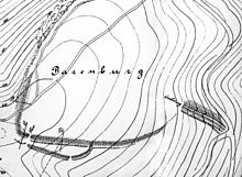
The Barenburg is 5.5 ha interior a spacious fortress building at Eldagsen in Lower Saxony . It lies on a steeply sloping mountain spur of the Osterwald about 350 above sea level. It is believed to have originated in the pre-Roman Iron Age , an archaeological excavation has not yet taken place. The function of the complex as a refuge for the population is likely to have continued into the Middle Ages , as it belonged to the property of the nearby Wülfinghausen monastery .
location
The former fortification is located on a wooded mountain spur about 3 km south of Eldagsen and 1 km west of the Wülfinghausen monastery. The steep elevation on the eastern edge of the Osterwald protrudes far into the plains and allows a wide view of the Calenberger Land .
description
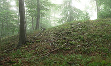
The Wallburg has an internal area of 5.5 hectares and is therefore one of the largest of its kind. The builders cleverly used the existing terrain to build the defense system. The rugged cliffs that slope down to the flatlands on the northwest side offered natural protection. The steep slopes to the east provide protection. In the south a 280 m long and mighty wall of stones was built. In connection with the remains of an upstream ditch, it is still several meters high today. In some parts the wall has a rampart. On the south side, an earlier access gate is suspected in a gap in the wall. It can no longer be reconstructed because the ground was disturbed by forestry work. In the southern apron of the facility, about 300 m away, there are smaller pieces of rampart that probably served as an obstacle to approaching enemies.
Origin and interpretation of use
Since no archaeological excavation has taken place so far, the time of origin can only be estimated based on the location and shape. After that, the complex is classified in the pre-Roman Iron Age , but this is only a rough estimate. An emergence in the early Middle Ages is also possible, as with similar fortifications in the vicinity (see below!). Due to the structure and the enormous size of 5.5 hectares of interior space, only a refuge for the population in times of danger comes into question as a function of the Barenburg . This function could have been maintained until the Middle Ages, because it belonged to the property of the Wülfinghausen monastery.
Robbery excavations
In 1988 robbery excavations on the area of the Barenburg became known after Iron Age metal objects with the location “Barenburg, Lower Saxony” were offered for sale at a coin exchange in Hanover. The police investigations led to a group of people from Berlin who confiscated around 400 finds from the Latène period. Based on the records of the predatory graves of the Barenburg, who were later convicted by the Springe District Court, they could be assigned to research. The improper recovery of the finds without documented localization led to a considerable reduction in the sources of the Barenburg finds.
Traces of a possible attack
In the years after the robbery excavations, the Lower Saxony State Office for the Preservation of Monuments carried out extensive prospecting on the Barenburg site as a preventive countermeasure. The found material recovered in the process was distributed over the entire inner surface of the Barenburg. They were items from all walks of life, such as metal tools, household appliances and agricultural implements. There were also jewelry components and weapon remains. The examination of the finds showed that they showed clear traces of violence. The tips of the lance were bent, had nicks and cuts, axes had broken off, sickles had nicks, brooches were bent and belt hooks were torn out of belts. The large number of objects found initially spoke in favor of a settlement of the fortification, for which no archaeological evidence could be found.
The archaeologist Erhard Cosack developed a theory according to which the fortifications, like the Amelungsburg in the Süntel, were attacked by Celts during the younger Iron Age and the inhabitants were abducted. The precipitation indicates that the population of the area has withdrawn to the Barenburg with their belongings. The damaged weapons indicate a fighting within the fortification after an attack from outside. Shoe nail traces, which the archaeologists followed over a 100-meter-deep steep slope, speak for the escape of the attacked population. The trail was accompanied by belongings that people might have lost or thrown away during the escape. The archaeologist Erhard Cosack assumes that the population was abducted. A hoard found in the oppidum of Manching provided evidence of Celts as attackers . It contained parts of belts and fibulae, the shape and peculiarities of which correspond to finds from the Barenburg and Amelungsburg in the absence of comparable pieces in southern Germany.
Similar fortifications in the vicinity

- In the plane:
- Isenburg near Barsinghausen -Landringhausen
- Düsselburg near Rehburg
- Lüningsburg near Neustadt am Rübenberge
- In height:
- Heisterburg near Lauenau - Feggendorf
- Wirkesburg near Lauenau-Feggendorf
- Heisterschlösschen near Beckedorf
- Kukesburg near Springe -Altenhagen
- Bennigser Castle near Bredenbeck- Steinkrug
- Sachsenwall near Nordstemmen
Fortifications of this kind were originally regarded as Saxon or Heinrichsburgen by archaeological research . The more recent research assigns the structures in the area of the Central Weser and the Leine to a period from the 8th to the 12th century. Due to the lack of settlement, the facilities are likely to have only been used sporadically and have served as refuges. In the case of the facilities in the Deister area (Wirkesburg, Bennigser Burg, Heisterschlösschen) it is typical that they were built on sloping mountain ridges and near a stream.
literature
- Hans-Wilhelm Heine : The Barenburg near Wülfinghausen . In: Guide to Prehistoric and Protohistoric Monuments , Volume 49. Part 2: Excursions; Mainz 1981
- Hans-Wilhelm Heine: The prehistoric and early historical castle walls in the district of Hanover , Hanover 2000, ISBN 3-7752-5645-8 , pp. 113-114.
- Margret Zimmermann, Hans Kensche: Castles and palaces in Hildesheimer Land . Hildesheim, 2001, pp. 39-40
- Erhard Cosack : The Barenburg near Eldagsen, Springe, Region Hannover in: New research on the Latène period fortifications in the former administrative district of Hannover , Neumünster 2008, pp. 48–53
- Erhard Cosack: Celtic attacks in the low mountain range of Lower Saxony. in: Archeology in Lower Saxony , Vol. 17. Oldenburg 2014, pp. 51–55
- Erhard Cosack: New traces of Saxon warriors in the Barenburg, near Eldagsen, Hanover region, and the battle of the Süntel in 782 AD. in: News from Lower Saxony's Prehistory , Vol. 87, 2017, pp. 233–246
Web links
- Entry by Hans-Wilhelm Heine and Stefan Eismann zu Barenburg in the scientific database " EBIDAT " of the European Castle Institute
- Barenburg in the Lower Saxony Monument Atlas
- Reconstruction drawing in the medieval state
- Description with photos at myheimat
Individual evidence
- ↑ Deported as slaves by the Celts? in Dewezet on May 9, 2010
Coordinates: 52 ° 8 ′ 37.1 ″ N , 9 ° 38 ′ 30.9 ″ E


