
Calenberger Land

The Calenberger Land is a historical landscape in what is now Lower Saxony , including Neustadt am Rübenberge , Hanover and Hameln . Today the name is mostly used as a regional designation for the much smaller southwest of the Hanover region , in which Calenberg Castle is located. It is separated to the east and north by the Leine and Mittellandkanal and bordered to the southwest by the Deister and to the south by the Kleiner Deister , both of which are still largely part of it. The Calenberger Land community group does not consist of all of these communities.
Name origin
The name of the Calenberger Land was given by the castle Calenberg near Pattensen , which dominated it in the Middle Ages , with the seat of the principality of the same name , but not the Kalenberg in the region of the neighboring Deister .
The Calenberger Loessbörde in the middle and the Calenberger Bergland in the south of the former principality are named after the Calenberger Land ; but these are physical landscapes and do not agree 1: 1 in their borders to the south, west and east with those of the former principality. This is how the Calenberger Bergland ends before Hameln and the city and the mountains southwest of it are not included, although they were in the Principality of Calenberg. Furthermore, the south of the Calenberger Loessbörde around Gronau and the (north) west of the Calenberger Bergland with the Weser Mountains and Deister were never in the principality.
geography
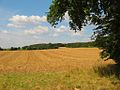
Landscape on Gehrdener Berg

Gehrdener Berg with Deister in the background


location
The geographic area of the Calenberger Land extends today to about 20 × 30 km. It lies on the left side of the Leine and is bordered to the west by the Deister , Kleinem Deister and Osterwald . The northern border roughly follows the course of today's BAB 2 between Hanover and Wunstorf .
Surveys
The inner elevations (without Deister and Kleine Deister) of the Calenberger Land include - the altitude is specified in meters (m) above sea level (NHN) and the rock ( red sandstone , shell limestone , Keuper , Jura , chalk ):
- Süllberg ( 199 m ; Jura)
- Schulenburger Berg ( 174 m ; red sandstone; Marienburg Castle on a 136 m high summit)
- Benther Berg ( 173 m )
- Limberg ( 159 m ; Muschelkalk, Keuper; immediately west of Gestorf )
- Gehrdener Berg ( 155 m ; chalk)
- Abraham (up to 134 m ; shell limestone; south-south-east continuation of the Limberg to Hallerburg )
- Stemmer Berg ( 123 m ; chalk)
- Sifter ( at the height ; 113 m ; red sandstone; immediately north of Eldagsen )
- Bettenser Berg ( 91.2 m ; shell limestone)
Flowing waters
The flowing waters of the Calenberger Land and the Calenberger Lössbörde include: Fosse , Haller , Ihme , Kirchwehrener Landwehr , Möseke and Südaue as well as, for example, as the north-eastern boundary of the landscape, the Leine , into which, for example, Fosse, Haller and Ihme flow, and as the north-western one Limitation of the western meadow , which is fed, among other things, by the southern meadow.
cities and communes
The cities of the Calenberger Land emerged in the Middle Ages when the ruling nobles granted them self-government and market rights. However, all places remained farming towns , in which many residents continued to work in agriculture. While today's residents mainly travel to Hanover as commuters , Hanover's city dwellers appreciate the area as a local recreation area.
The cities and municipalities of the Calenberger Land are:
geology
Part of the Calenberger Land is the 684 km² Calenberger Loessbörde , which arose during and after the Vistula Ice Age. Strong north winds deposited the loess in layers of 0.2 to 2 m thick, which turned into clay in the upper layers . Due to the fertile soil, the area is heavily influenced by agriculture.
Under the Calenberger Börde, mineral resources that were already used in the Middle Ages are stored near the surface . These are potash salts that were mined near Ronnenberg and Benthe . In the neighboring Deister coal and sandstone and limestone were mined , in the nearby Kleiner Deister clay minerals for burning bricks and in the lower terrace of the Leine sand and gravel were mined.
history

The current geographic area of the Calenberger Land corresponds roughly to the Germanic Marstemgau . The Billunger ruled here in the early Middle Ages . From the 12th century rulership areas were formed by regional count families who received their property as fiefs from the Minden and Hildesheim bishops . These were the Counts of Wölpe ( Nienburg / Weser ), von Roden ( Wunstorf ), von Schaumburg , von Schwalenberg ( Barsinghausen ), von Spiegelberg ( Lauenstein ) and von Hallermund ( Springe ). During this time the counts donated a number of monasteries, such as the Mariensee Monastery , the Marienwerder Monastery , the Barsinghausen Monastery , the Wennigsen Monastery and the Wülfinghausen Monastery . In the 13th century the Guelphs got the upper hand in the Calenberger Land, which did not yet bear this name. They bought their lands from the counts or defeated their feudal givers, the bishops of Hildesheim and Minden. In the 13th century the Guelph erected south of Hanover in line near the Wasserburg Calenberg . Then the Guelph Principality of Calenberg came into being. In this way, the dominion of the Principality of Calenberg developed , which used to be much larger than the Calenberger Land today. In the 15th century it extended to Nienburg / Weser in the north and Hameln in the south-west . In 1495 the Principality of Calenberg was merged with the Principality of Göttingen to form the Principality of Calenberg-Göttingen .
During the Hildesheim collegiate feud in 1519 there was severe devastation in the area. A map made in 1590 shows almost all places in the Calenberger Land burning. In 1542 the area became Lutheran through the Duchess Elisabeth von Brandenburg . Anton Corvinus carried out the Reformation on their behalf. An attempt at recatholization by Duke Erich II during the Schmalkaldic War failed because of popular resistance.
During the Thirty Years' War , Tilly's troops marched in in 1625 and took the fortress of Calenberg after three weeks of siege. The general ruled the entire Calenberger Land with the exception of Hanover. The fortress was not recaptured until 1633.
In the 19th century, the area of the principality of Calenberg, together with the counties of Hoya and Diepholz, became Landdrostei , the later administrative district of Hanover , which existed until 2004 . A sustained economic upswing in the Calenberger Land came about through the increased use of geological and agricultural resources, such as potash mining , and intensive sugar beet cultivation with sugar and cement factories.
Attractions
- Bennigser Castle
- Calenberg Castle
- Hallermund Castle
- Calenberg monasteries
- Saupark Jump
- Marienburg Castle
- Wisent enclosure jump
Goods and manors
- Bredenbeck Manor , Baron Knigge , Wennigsen
- Stemmen manor , from Rössing, Barsinghausen
- Wichtringhausen manor , Langwerth von Simmern, Barsinghausen
- Großgoltern manor , Barsinghausen
- Langreder manor , von Ilten, Barsinghausen
- Manor Eckerde I, from Heimburg , Barsinghausen
- Eckerde II manor, Barsinghausen
- Egestorf manor , Barsinghausen
- Franzburg Manor , Gehrden
- Rittergut Lemmie , from Ditfurth, Gehrden
- Obergut Lenthe , from Lenthe, Gehrden
- Untergut Lenthe, from Richthofen , Gehrden
- Manor Leveste , Baron Knigge, Gehrden
- Manor Erichshof , Gehrden
- Good Leveste, Gehrden
- Domain Calenberg , Pattensen
- Dunau Manor , Seelze
- Manor Gestorf I, jump
- Manor Gestorf II, jump
- Bennigsen manor , jump
- Rittergut Bockerode , Springe
- Rittergut Bettensen, Baron von Münchhausen , Ronnenberg
- Rittergut Düendorf, Wunstorf
- Hemmingen manor , from Campe (formerly von Alten), Hemmingen
See also
- Calenberg mountains
- Calenberger Loessbörde
- Calenberger Neustadt
- Callenberg (noble family)
- Kingdom of Hanover
Individual evidence
- ↑ Interactive historical map of Lower Saxony 1789 with the principality of Calenberg, on hoeckmann.de
- ↑ Topographic map : "Calenberger Land" ( memento of the original from August 2, 2016 in the Internet Archive ) Info: The archive link was inserted automatically and has not yet been checked. Please check the original and archive link according to the instructions and then remove this notice. in the south of the Hanover region with district boundaries (in ÜKN 500), on natur-erleben.niedersachsen.de
- ^ ILE region Calenberger Land
- ↑ GeoViewer of the Federal Institute for Geosciences and Raw Materials ( information )
- ↑ Topographic map with the Süllberg ( memento of the original from August 2, 2016 in the Internet Archive ) Info: The archive link was inserted automatically and has not yet been checked. Please check the original and archive link according to the instructions and then remove this notice. (DTK 25; for height see top contour line in DTK50 – AK2.5), on natur-erleben.niedersachsen.de
- ↑ Topographic map with the Schulenburger Berg ( memento of the original dated August 2, 2016 in the Internet Archive ) Info: The archive link was inserted automatically and has not yet been checked. Please check the original and archive link according to the instructions and then remove this notice. (DTK 25; for height see top contour line in DTK50 – AK2.5), on natur-erleben.niedersachsen.de
- ↑ Topographic map with the Benther Berg ( memento of the original from August 2, 2016 in the Internet Archive ) Info: The archive link was automatically inserted and not yet checked. Please check the original and archive link according to the instructions and then remove this notice. and its summit in the south-southwest (DTK 50; for height see top contour line in AK 5 and 2.5), on natur-erleben.niedersachsen.de
- ↑ Limberg ( Memento of the original from August 2, 2016 in the Internet Archive ) Info: The archive link was automatically inserted and not yet checked. Please check the original and archive link according to the instructions and then remove this notice. (DTK 25; for height see top contour line in AK 5 and 2.5), on natur-erleben.niedersachsen.de
- ↑ Topographic map with northern and central parts of Gehrdener Berg ( Memento of the original from August 2, 2016 in the Internet Archive ) Info: The archive link was inserted automatically and has not yet been checked. Please check the original and archive link according to the instructions and then remove this notice. and Burgberg in the north (DTK 50; for height see top contour line in AK 5 and 2.5), on natur-erleben.niedersachsen.de
- ↑ Map view (AK 2.5) ( Memento of the original from December 10, 2014 in the Internet Archive ) Info: The archive link was inserted automatically and has not yet been checked. Please check the original and archive link according to the instructions and then remove this notice. the highest place of Abraham
- ↑ Topographic map with the Stemmer Berg ( memento of the original dated August 2, 2016 in the Internet Archive ) Info: The archive link was inserted automatically and has not yet been checked. Please check the original and archive link according to the instructions and then remove this notice. (DTK 50; for height see top contour line in AK 5 and 2.5), on natur-erleben.niedersachsen.de
- ↑ Bettenser Berg with its summit in the south-southwest, in map services of the Federal Agency for Nature Conservation , on bfn.de
- ↑ Landscape profile : Calenberger Lößbörde ( Memento of the original from August 28, 2010 in the Internet Archive ) Info: The archive link was inserted automatically and has not yet been checked. Please check the original and archive link according to the instructions and then remove this notice. (No. 52100) with map of the Federal Agency for Nature Conservation, on bfn.de
literature
- Carl-Hans Hauptmeyer : Calenberg, history and society of a landscape in Lower Saxony. Hanover 1983, ISBN 3-7716-1437-6 .
Web links
- Interactive historical map of Lower Saxony 1789 with the Principality of Calenberg, on hoeckmann.de
- Maps of the former Principality of Calenberg and the former Principality of Grubenhagen , on Landschaftsverband.org
- Prospecting medieval sites in the Calenberger Land (to explore theimageof the settlement at that time) in investigations into the prehistoric and medieval settlement history of the Calenberger Land , on gwdg.de (PDF; 94 kB)
- On the way in Calenberger Land , NDR television , from April 4, 2015, on ndr.de