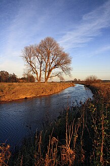
Westaue
| Westaue | ||
|
The western meadow south of Liethe |
||
| Data | ||
| Water code | EN : 4888 | |
| location | In Lower Saxony | |
| River system | Weser | |
| Drain over | Leine → Aller → Weser → North Sea | |
| source | At Auhagen from Sachsenhäger Aue | |
| Source height | 50 m above sea level NN | |
| muzzle | At Wunstorf on the Leine coordinates: 52 ° 27 '16 " N , 9 ° 28' 6" E 52 ° 27 '16 " N , 9 ° 28' 6" E |
|
| Mouth height | 35 m above sea level NN | |
| Height difference | 15 m | |
| Bottom slope | 1.2 ‰ | |
| length | 12.5 km | |
| Catchment area | 600 km² | |
| Discharge at the Wunstorf A Eo gauge : 558 km² Location: 5.2 km above the mouth |
NNQ (10/11/1982) MNQ 1979/2014 MQ 1979/2014 Mq 1979/2014 MHQ 1979/2014 HHQ (12/31/1986) |
380 l / s 669 l / s 3.92 m³ / s 7 l / (s km²) 51.2 m³ / s 107 m³ / s |
| Left tributaries | Murder pit | |
| Right tributaries |
Rodenberger Aue , Osterriehe, Südaue , Alte Südaue |
|
| Small towns | Wunstorf | |
The Westaue is a 12.5 km long, left tributary of the Leine in the district of Schaumburg and in the Hanover region in Lower Saxony .
The Westaue is the continuation of the Sachsenhäger Aue from the tributary of the Rodenberger Aue east of Auhagen and south of the Steinhuder Meer in the Schaumburg district. After around 800 m it crosses the district border and flows through Mesmerode , Bokeloh , Wunstorf , Blumenau and Liethe.
The Westaue flows into the Leine between Liethe and Bordenau .
The almost 13 km long western floodplain has only 3 other tributaries: the Osterriehe, the Mordgraben and the southern floodplain , which rises near Barsinghausen in the Deister. Through the three floodplains that the western floodplain takes up, it carries water from the Deister , the Süntel , the Bückeberg and the Rehburger mountains into the Leine.
It received its diked river bed north of the old town of Wunstorf by diverting and closing the south and north floodplains (on the south wall and north wall of the old town) and lifting the mill dam (on the north wall for the Langhorst water mill) in the 1970s. This regulation of the river put an end to the frequent flooding of parts of the old town.
Individual evidence
- ↑ List of waters. Entertainment Association West and Südaue, 2014, accessed on November 18, 2014 .
- ^ German Hydrological Yearbook Weser-Ems 2014. Lower Saxony State Agency for Water Management, Coastal and Nature Conservation, p. 202, accessed on October 4, 2017 (PDF, German, 8805 kB).
