Stemmer mountain
| Stemmer mountain | |
|---|---|
|
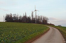
View from the east to Stemmer Berg |
|
| Highest peak | Kuckuckshagenberg ( 123 m above sea level ) |
| location | at mortising ; Region Hannover , Lower Saxony ( Germany ) |
| landscape | Calenberger Land |
| Coordinates | 52 ° 21 ' N , 9 ° 32' E |
| particularities | Cell phone mast, wind power and water production plant on the highest peak |

The Stemmer mountain is 123 m above sea level. NHN high ridge within the Calenberger Land . It is located near Stemmen in the Hanover region of Lower Saxony ( Germany ).
geography
location
Stemmer mountain rises between the village Seelze district Lathwehren and its local situation Dunau in the northeast and the village Barsinghäuser districts Göxe the southeast, Barrigsen in the northwest and caulking in the southwest. To the north lies the origin of the Möseke , a tributary of the Südaue that passes the ridge to the southwest . The Stemmer Berg is around 3.5 km long in the south-east-north-west direction between Göxe and Barrigsen and around 2.8 km wide in the south-south-west-north-north-east direction between the rivers just mentioned. Neighbors are the Benther Berg ( 173.3 m ) located about 6 km to the east, the Gehrdener Berg ( 155 m ) located about 5 km to the southeast and the Deister ( 405 m ) located about 10 km south to southwest .
Natural allocation
The Stemmer Berg belongs to the natural spatial main unit group Lower Saxony Börden (No. 52), in the main unit Calenberger Lößbörde (521) and in the subunit Hannoversche Börde (521.0) to the natural area Gehrdener Loesshügel (521.01). To the northeast, north to west-northwest, the landscape descends into the natural area of Kirchwehrener Hügelland (521.00).
Surveys
The Stemmer Berg has the following peaks - with a height in meters (m) above mean sea level:
| Elevation | Height (m) |
Dominance | Notch height | comment |
|---|---|---|---|---|
| Kuckuckshagenberg | 123 | 4.6 km ( Gehrdener Berg ) |
approx. 63 m | in the southeast, between Stemmen and Göxe |
| Zungenberg | 119.7 | 0.4 km (Kuckuckshagenberg) |
approx. 10 m | with spur Schafberg (about / by 102 m ), in the middle, between Stemmen and Dunau |
| Langefeldsberg | 93 | approx. 70 m (Zungenberg) |
approx. 6 m | The spur severed by cutting the K 246 in the middle |
| Elevation at the mountain field | 88.9 | 0.6 km (Langefeldsberg) |
approx. 8 m | in the northwest, between Stemmen and Barrigsen |
Nature, geology, mining
The Stemmer Berg is made up of small trees. Because of its loess soil, it is mainly used as arable land. Parts of the Benther Berg-Südaue landscape protection area lie on it (CDDA no. 319866; designated in 1969; 46.47 km² in size).
There used to be a quarry that has now been backfilled. The ridge was known for the rare mineral chalcophanite (the only occurrence in Lower Saxony) and the more common mineral aragonite . In the years 1817 to 1858 Wealden coal was mined east of Stemmen .
Infrastructure, traffic and hiking
At the top of the highest elevation of the Stemmer Berg is a private property with a residential building and dilapidated greenhouses of a nursery in a forest; the address is paradise , which is due to the charming location. There is also a cell phone mast there, as well as a wind power and water extraction system.
Immediately to the south, past Stemmer Berg, the federal road 65 runs in a west-east direction in the Stemmen – Göxe section . Directly south of Stemmen branches off from the B 65, the county road 245, from which the K 246 branches off in the village, first north and then north-east over the ridge to Lathwehren. The latter leads between the Zungenberg and Langefeldsberg through a depression in the terrain at a height of about 88 m ; a little northeast of this depression branches off from the road at a height of 82.3 m .
The Stemmer Berg is connected to the neighboring Benther Berg and Gehrdener Berg by paths and paths. The ridge is used by cyclists and hikers. There is a view over the Deistermulde plain in the Calenberger Land to the Deister and the Gehrdener Berg.
Individual evidence
- ↑ a b c d e f g h Topographic map with the Stemmer Berg ( memento of the original dated August 2, 2016 in the Internet Archive ) Info: The archive link was inserted automatically and has not yet been checked. Please check the original and archive link according to the instructions and then remove this notice. (DTK 50; for heights see top contour lines in AK 5 and 2.5), on www.natur-erleben.niedersachsen.de
- ^ Sofie Meisel: Geographical land survey: The natural space units on sheet 86 Hanover. Federal Institute for Regional Studies, Bad Godesberg 1962. → Online map (PDF; 4.0 MB)
- ↑ a b c Map services of the Federal Agency for Nature Conservation ( information )
- ^ Karl-Heinz Grimme: Coal mining in the Stemmer Berg area. (pdf; 3.11 MB) in: The Wealden hard coal mining in Lower Saxony . Mining Working Group of the adult education center in Schaumburg, pp. 177–178 , accessed on September 17, 2016 .
Web links
- Wolfgang Blockus: Am Stemmer Berg (photos from 2001), on galerie-im-keller.de


