
Gehrden
| coat of arms | Germany map | |
|---|---|---|

|
Coordinates: 52 ° 19 ' N , 9 ° 36' E |
|
| Basic data | ||
| State : | Lower Saxony | |
| County : | Hanover region | |
| Height : | 72 m above sea level NHN | |
| Area : | 43.1 km 2 | |
| Residents: | 14,962 (Dec. 31, 2019) | |
| Population density : | 347 inhabitants per km 2 | |
| Postal code : | 30989 | |
| Primaries : | 05108, 05137, 05109 | |
| License plate : | H | |
| Community key : | 03 2 41 006 | |
| LOCODE : | DE GHD | |
| City structure: | 7 districts | |
City administration address : |
Kirchstrasse 1–3 30989 Gehrden |
|
| Website : | ||
| Mayor : | Cord Mittendorf ( SPD ) | |
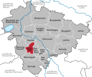
| Location of the city of Gehrden in the Hanover region | ||
  |
||


Gehrden is a small town in the Hanover region of Lower Saxony .
geography
Location / elevations
The city of Gehrden is located in the Calenberger Land . West of the city center is the Gehrdener Berg with the Burgberg , which is 158 m above sea level. NHN has. The highest elevation is the Benther Berg in the west of the town of Benthe (town of Ronnenberg ), east of the Gehrden districts of Everloh and Northen at 179 m above sea level. NHN . The city itself is at an altitude of 70–90 m above sea level. NHN.
City structure
The city of Gehrden consists of the following districts:
Neighboring communities
| Seelze | Hanover | |
| Barsinghausen |
.svg)
|
Ronnenberg |
| Wennigsen (Deister) |
history
Prehistory and early history
The area of today's city of Gehrden was already settled during the Bronze Age . From this time there are traces of buildings that archaeologists discovered in 2014 during the development of the new development area Großes Neddernholz around one kilometer east of the town center. Numerous post pits could be recognized from the discoloration of the soil . They belonged to small storage buildings and an almost 30 meter long nave . There were also settlement pits with remains of ceramic vessels and animal bones, as well as fireplaces. Although the finds initially did not allow an exact dating, it is believed that the settlement existed around 3000 years ago.
In later times there was a Germanic settlement in today's urban area from around the 3rd to 6th centuries . Archaeologists found this during excavations in 2010 and 2011 in an industrial park about 1.3 km north of the town center. There were pit houses , waste pits , a well, a pottery kiln and large quantities of bones of wild boar . The ceramic remains found are attributed to the southern Hanoverian turntable ware from around 400 AD. Due to the rich finds, archaeologists assume that members of a Germanic elite lived here and controlled the Hellweg , which runs past in the west-east direction .
Middle Ages until today
It was first mentioned in a document in 1153. The place is called "Gerdinum", later "Gerdene", "Gherden", "Gherdene", "Gerde" and "Herden" and interpreted as a "settlement near the Malstatt". Apart from the court confirmed in 1353 and the “Dingbuche” (1359), different fields still point to the Malstatt today: the “hillige Kamp”, “achter dem Recht” and “Wulfwinkel”.
In a later document from January 28, 1298, Count Adolf VI. von Schauenburg and Holstein , as overlord of his town Gehrden ( oppidum nostrum ) an immunity privilege; He declared the place free and, in particular, granted security and freedom to all who lived and wanted to live there and at the same time gave freedom to his own relatives who lived here by issuing them the appraisals and only reserving his preferential rights to himself. The place received a market, brewing rights, its own jurisdiction and fortification rights. Before that, the Margarethenkirche was built around 1250 . Urban archaeological investigations in 2016 revealed that the town center had already been continuously settled in the 12th century . During the excavations on a plot of land intended for rebuilding, traces of medieval settlement were found. These included the remains of a fortification wall, a house with a cellar and five wells with partly dendrochronologically datable remains of wood. A clay knight figure found is dated to the 14th century and is considered a children's toy. In 2020, renovation work on the market square found 25 more archaeological remains in addition to the Margaret Church and the Steinweg house . It was a sandstone fountain from the 17th to 19th centuries, remains of bones from Christian burials in the churchyard of Margaret Church and remains of the foundations of an early modern building. It could be the Schaumann house, which was demolished in the 1970s, or its process building.
In the years 1467, 1562, 1628 and 1665 the community was devastated as a result of several feuds and fires. In the years 1803–1815, French and Russian billeting polluted the place, which in 1812 had to provide soldiers for Napoleon's 1812 Russian campaign .
The town charter was Gehrden in 1929 awarded.
During the time of National Socialism , a self-proclaimed, "eager leader of the Volkssturm [...] was called to take care of a dubious order in Gehrden". The NSDAP district leader Heinz Deinert killed together with Karlheinz Scheu in the spring of 1945 - shortly before the liberation by troops of the US army - the French- Jewish slave laborer Felix Pichet.
Until December 31, 2004, Gehrden belonged to the Hanover administrative district , which, like the other administrative districts of Lower Saxony, was dissolved.
Incorporations
On August 1, 1971, the community merged voluntarily with the surrounding rural communities Ditterke, Everloh, Lemmie, Lenthe, Leveste, Northen and Redderse to form the large community of Gehrden.
Population development
|
|
|
1 131 fireplaces
2 in 137 houses
3 census results (with the places incorporated in 1971 = 9,983 inhabitants)
4 censusresults(with the places incorporated in 1971 = 12,324 inhabitants)
5 on December 31st

|
Religions / denominational statistics
In 2017, 39.4% (2014: 41.1%) of the population were Evangelical Lutheran and 12.1% (2014: 11.11%) Roman Catholic. 48.2% (2014: 46.5%) belonged to other denominations or religious communities or were non-denominational . In June 2018, 39.3% of the population were Protestant, 12.0% Catholic and 48.7% did not belong to either of the two Christian denominations.
politics
City Council
The council of the city of Gehrden consists of 6 council women and 21 councilors.
The full-time mayor is also entitled to vote and sit on the council. Council chairman is Peter Lübcke (CDU).
The last local election on September 11, 2016 resulted in the following:
| Political party | Proportional votes | Number of seats |
|---|---|---|
| SPD | 29.2% | 9 |
| CDU | 33.4% | 9 |
| Green | 16.5% | 5 |
| FDP | 7.1% | 2 |
| The left | 2.8% | 1 |
| AfD Lower Saxony | 9.9% | 3 |
- The individual nomination by Schultz could not win a seat in the council
- The Greens have formed a group in the Council together with the Die Linke party
mayor
The full-time mayor of the city of Gehrden is Cord Mittendorf (SPD). Mittendorf prevailed in a runoff election on June 15, 2014 against the previous incumbent Hermann Heldermann (CDU). Cord Mittendorf is the first social democratic mayor since 1976. Deputy mayors are Henning Harter (SPD), Heinrich Meinecke (CDU) and Heide Rath (CDU).
coat of arms
The design of the municipal coat of arms of Gehrden comes from the heraldist and graphic artist Alfred Brecht , who designed all the coats of arms in the Hanover region.
- The approval of the coat of arms was granted on April 26, 1961 by the district president in Hanover.
- The city of Gehrden, which was newly formed by law on August 1, took over the coat of arms of the previous city of Gehrden, which was approved by the Hanover district on February 22, 1984.
|
|
Blazon : "In red the silver stepped gable of the town church , covered from the shield base with the coat of arms of the Counts of Schaumburg (in red a silver nettle leaf ) and that of the Guelph dukes (in blue a red-armored , golden lion )." |
| Justification for the coat of arms: The old town seals from 1551 and 1600 used the steeple of the Margarethenkirche as a symbol, albeit in the enriched form common in the Middle Ages with additional flags that probably only had to fill in the shield image. A torn leopard head was placed in the open gable as a sign of recognized Guelph rule. Based on the seal and historical facts, the heraldist submitted three drafts to the city council, of which the council unanimously approved the coat of arms described above at its meeting on March 9, 1961. |
Culture and sights


Buildings
Churches
- The Margarethenkirche on Kirchstrasse, which has been Evangelical Lutheran since the Reformation, is the historic village church of Gehrden. Its tower with the characteristic stepped gable dates from the early 13th century and has been in the city seal for over 500 years, as well as in the city's coat of arms today. The nave was built at the end of the 15th century. Your parish belongs to the parish of Ronnenberg in the district of Hanover . This also includes the Nedderntor kindergarten and the chapels in the districts of Ditterke , Lemmie ( Lemmier chapel ) and Redderse ( Redderse chapel ).
- The Catholic St. Bonifatius Church , built in 1911 in the neo-baroque style, is located on Gartenstrasse. It was expanded in 1981 and contains an organ built in 1992. Your parish, which also includes the Catholic churches in Barsinghausen and Wennigsen , is part of the Hanover deanery .
- The New Apostolic congregation in Gehrden was given up; it belonged to the Hannover-Mitte church district. The last service took place at the end of March 2011 in their church at Grosse Bergstrasse 40. The church building erected in 1969 was sold and demolished in the summer of 2012; an apartment building was built on the property. The nearest New Apostolic Church is today in Hanover-Badenstedt, eight kilometers away.
Other structures
- The Struckmeyersche mill in 1878 as a Dutch windmill on the Köthnerberg built, its predecessor was a 1729 built windmill .
- The Hanoverian horticultural director Julius Trip had the historic Tripsche park with a view over the Calenberger Land towards Deister completed in 1898. The park was restored in 1991 by the Greater Hanover (today: Region Hanover ). The Lower Saxony mountain inn , which was completed in 1898 and demolished in 1959, was embedded in the park .
- The Burgberg Tower was built in 1897/1898 on the Gehrdener Berg in the middle of the ring wall on the Gehrdener Berg . It is around 21 m high and its viewing platform is 176.69 m above sea level. NHN . The tower was restored in 1985 by the city of Gehrden and released as a lookout tower .
- The Franzburg manor was a manor that was built around 1650 and the manor house was demolished in 1967. Only parts of the manor wall and the gate structures remain. The former estate park is now open to the public as Ottomar-von-Reden-Park and is a cultural monument.
- The historic brewery was rebuilt after a fire in 1665 and has housed the Gehrden City Museum since 1975 .
- The turret is a fire brigade's fire station that was expanded in 1910 and has served as a restaurant since 1976.
- The Jewish cemetery is a Jewish cemetery that was occupied from 1752 to 1935 in the city area.
- The Waldschlösschen was a restaurant on the Köthnerberg built around 1898, which was demolished in 1971.
Photo gallery

Berggasthaus Lower Saxony around 1898

Struckmeyer's mill


societies
- The local branch of the Social Democratic Party of Germany (SPD) was founded in 1906 as the first political party in Gehrden.
- In 1992 the art association Gehrden was founded on the initiative of art-interested citizens of Gehrden with the aim of promoting contemporary art and artists. There are annual art exhibitions. The art association has its seat in the town hall of Gehrden.
Sports
The Gehrden sports club was founded in 1900 and with 2500 members (as of 2011) is the largest Gehrden club. In 2011 the 1st Gehrden Golf Club was founded with the aim of building a golf course in Gehrden. With 250 members (as of 2014), the association is one of the larger in the city. In the center of the village is the Delfi-Bad, a combined indoor and outdoor pool.
Economy and Infrastructure


Companies
From 1872 the Seemann brickworks processed the clay and loam deposits of the Gehrdener Berg.
The sugar factory was in operation from 1857 to 1930. The “Vorwerk” carpet factory was later built on the site and was relocated to Hameln in 1985 .
With the construction of the supply line for the Harz waterworks to Bremen, Gehrden was provided with a central water supply in 1934.
education
- There are eight municipal and one church day care center with a total of 78 crèche places, 421 kindergarten places and 60 day care places.
- In the city center there is the primary school Am Castrum with 328 students and the primary school Am Langen Feld with 173 students.
- From the 2011/2012 school year, the Gehrden Oberschule is located near the Gehrden indoor and outdoor swimming pool with a grammar school branch up to grade 10 ( secondary level I ).
- The Matthias-Claudius-Gymnasium is located on the eastern slope of the Burgberg with a high school and approx. 930 students.
- The Zweckverband Volkshochschule Calenberger Land is a further education institution of the cities of Barsinghausen, Gehrden, Ronnenberg, Seelze, Springe and the municipality of Wennigsen and operates an office in Gehrden in the former "Red School" with educational offers.
- The Calenberg Music School is based in Gehrden in the building of the Gehrden Oberschule and teaches around 1000 students from Gehrden, Ronnenberg and Barsinghausen.
- In the youth pavilion, youth care Gehrden offers children and young people action and care programs.
traffic
The medieval Hellweg from Minden to Hildesheim led through the urban area of Gehrden. Today the federal highway 65 crosses the urban area in the north from east to west, while the road leads through the places Everloh and Ditterke. The federal highway B 217 passes a few kilometers east of the urban area .
In 1898 the tramway Hannover AG (from 1921: ÜSTRA ) opened the tram line 10 from Hannover to Gehrden - from 1899 also to Barsinghausen. The construction of the tram resulted in an economic upswing, as it meant that electricity was also available in the village. In addition to passengers, the tram also carried coal, vegetables and other goods from Barsinghausen as well as sugar from the Neuwerk sugar factory to Hanover. Passenger transport on the section to Barsinghausen was discontinued on July 27, 1952, goods transport on November 30, 1953. On July 3, 1961, the route from Hanover to Gehrden was also shut down and replaced by bus connections. ( see also: History of the tram in Hanover )
Personalities
Honorary citizen
- Heinrich Berkefeld, Mayor
- Heinrich Hische, Mayor
- August Kageler (1877–1965), teacher, author and local history researcher
- Ernst Mittendorf, council member, district council and regional assembly member
- Helmut Oberheide, Mayor
- Ottomar von Reden (1888–1959), mayor
sons and daughters of the town
- Friedrich Ulrich von Knigge (1618–1683), imperial colonel, born in Leveste
- Werner von Siemens (1816–1892), inventor, founder of electrical engineering and industrialist
- Hans-Joachim Frey (* 1965), theater director
- Anja Jensen (* 1966), artist
- André Buron (* 1967), journalist
- Tim Pritlove (* 1967), event manager, media artist and member of the Chaos Computer Club
- Wolfgang Kreißig (* 1970), high jumper
- Klaus Wannemacher (* 1972), Germanist, theologian and university professor
- Jan Philip Lange (* 1974), film producer
- Christian Haacke (* 1976), radio presenter
- Saskia Richter (1978–2015), political scientist
- Christian Pampel (* 1979), national volleyball player
- Nils Pfingsten-Reddig (* 1982), soccer player
- Kristin Demann (* 1993), soccer player
- Hendrik Weydandt (* 1995), football player
People connected to the city

- Justus Wilhelm Lyra (1822–1882), pastor and composer, died in Gehrden
- Werner Osenberg (1900–1974), materials scientist, lived in Gehrden since the 1950s
- Werner Lueg (1931–2014), athlete, Olympic champion in 1952, died in Gehrden
- Maria Schrader (* 1965), actress and director, she attended the Matthias-Claudius-Gymnasium in Gehrden
- Marc Bator (* 1972), news anchor ( ARD-Tagesschau 2000–2013, since then on Sat.1 ), attended the Matthias-Claudius-Gymnasium Gehrden
- Sebastian Schunke (* 1973), Latin jazz pianist, composer and lawyer, spent his childhood in Gehrden
- Grischa Niermann (* 1975), racing cyclist, lives in Gehrden
literature
- Werner Fuetterer: Gehrden - From the spot to the large community. Gehrden 1991.
- Gerold Steinhorst: Gehrden street names. Gehrden 1998.
- Martina Grohmann: Gehrden - aspects of local history. Gehrden 1994.
- August Kageler: Gehrden. Development and fate of a small town in Calenberg. With drawings and illustrations by Helmut Müller. Gehrden 1950.
Web links
Individual evidence
- ↑ State Office for Statistics Lower Saxony, LSN-Online regional database, Table 12411: Update of the population, as of December 31, 2019 ( help ).
- ↑ Dirk Wirausky: Homesteads once stood in Neddernholz. In: Website Hannoversche Allgemeine Zeitung . August 6, 2014, accessed October 8, 2017 .
- ↑ On the trail of the Teutons in Gehrden. In: Website Neue Presse . September 21, 2011, accessed October 8, 2017 .
- ↑ A Germanic Big Man in Gehrden? In: Archeology online. September 28, 2011, archived from the original on December 3, 2013 ; accessed on November 1, 2019 .
- ↑ Ute Bartelt : In the best location - a settlement of the 1st millennium by Gehrden on Hellweg in: Babette Ludowici (ed.): Saxones , Theiss, Darmstadt 2019, pp. 87-88
- ↑ a b c d e district of Hanover (ed.): Wappenbuch district of Hanover . Self-published, Hanover 1985, p. 144-147 .
- ↑ Dirk Wirausky: Toys are the oldest found objects. In: Website Hannoversche Allgemeine Zeitung. August 24, 2016. Retrieved October 8, 2017 .
- ↑ Ingo Rodriguez: Gehrden's city history is extended. In: Website Hannoversche Allgemeine Zeitung. October 11, 2016, accessed October 8, 2017 .
- ↑ The history of the settlement comes to light. In: hannover.de. August 25, 2016. Retrieved October 8, 2017 .
- ↑ Remnants of wood on wells provide insight into the early history of the settlement. (PDF; 577 kB) In: Calenberger online news. October 11, 2016, accessed October 8, 2017 .
- ↑ Maximilian Hett: Archaeologists research the nucleus of Gehrden. In: Website Norddeutscher Rundfunk . August 24, 2016. Retrieved October 8, 2017 .
- ↑ Dirk Wirausky: The renovation of the market square is making good progress. In: Website Hannoversche Allgemeine Zeitung. June 17, 2020, accessed June 24, 2020 .
- ↑ Raimond Reiter: Empirical analysis and methods in research into the “Third Reich”: case studies on content analysis, type formation, statistics, on interviews and personal reports . Ed .: Peter Lang. Self-published, Frankfurt am Main / Berlin / Bern / Bruxelles / New York / Oxford / Vienna 2000, ISBN 3-631-36367-2 , p. 167 ( digitized version in Google Book Search [accessed November 1, 2019]).
- ↑ a b c Federal Statistical Office (ed.): Historical municipality directory for the Federal Republic of Germany. Name, border and key number changes in municipalities, counties and administrative districts from May 27, 1970 to December 31, 1982 . W. Kohlhammer, Stuttgart / Mainz 1983, ISBN 3-17-003263-1 , p. 196 .
- ^ Friedrich Jansen: Statistical Manual of the Kingdom of Hanover (= Statistical Manuals for the Kingdom of Hanover ). Helwing'sche Hofbuchhandlung, Celle 1824, p. 206 ( digitized version in Google Book Search [accessed November 1, 2019]).
- ↑ Friedrich W. Harseim, C. Schlüter: Statistical Handbook for the Kingdom of Hanover (= Statistical Handbooks for the Kingdom of Hanover ). Schlüter'sche Hofbuchdruckerei, Hanover 1848, p. 54 ( digitized version in Google Book Search [accessed November 1, 2019]).
- ↑ a b c d e f Michael Rademacher: German administrative history from the unification of the empire in 1871 to the reunification in 1990. District of Hanover ( see under: No. 22 ). (Online material for the dissertation, Osnabrück 2006).
- ^ Ulrich Schubert: Community directory Germany 1900 - Linden district. Information from December 1, 1910. In: gemeindeververzeichnis.de. January 5, 2020, accessed June 19, 2020 .
- ↑ a b Statistisches Bundesamt Wiesbaden (ed.): Official municipality register for the Federal Republic of Germany - 1957 edition (population and territorial status September 25, 1956, for Saarland December 31, 1956) . W. Kohlhammer, Stuttgart 1958, p. 159 ( digitized version ).
- ↑ Lower Saxony State Administration Office (ed.): Municipal directory for Lower Saxony . Municipalities and municipality-free areas. Self-published, Hanover January 1, 1973, p. 23 , District of Hanover ( digitized version ( memento from August 7, 2019 in the Internet Archive ) [PDF; 21.3 MB ; accessed on June 19, 2020]).
- ↑ a b c d e f g h i j community directory - archive - regional structure - annual editions - Lower Saxony. (All politically independent municipalities in EXCEL format). In: Destatis website. Federal Statistical Office, accessed on November 1, 2019 .
- ↑ Annual statistical report 2017 City of Gehrden 3.4 Resident population by denomination. In: Website City of Gehrden. Retrieved July 8, 2019 .
- ↑ Catholic in the Hanover region Table 1: Population at the place of main residence according to Catholic and Protestant religious affiliation. (PDF; 631 kB) In: hannover.de. June 30, 2018, p. 2 , accessed June 18, 2020 .
- ↑ a b Municipal election 2016. In: Website election results in the Hanover region. September 11, 2016. Retrieved October 12, 2016 .
- ↑ a b Council of the City of Gehrden. In: Council information system of the city of Gehrden. Retrieved November 1, 2019 .
- ↑ The Greens and the Left form a group in the city council. In: gruene-gehrden.de. October 30, 2016. Retrieved November 20, 2016 .
- ↑ a b c d e Gehrden is also an honorary citizen of Reden. In: gehrden.de. June 21, 2012, accessed January 17, 2019 .
- ↑ Ernst Mittendorf is the sixth honorary citizen of the city of Gehrden. In: www.gehrden.de. May 10, 2012, accessed January 17, 2019.
Barsinghausen | Burgdorf | Burgwedel | Garbsen | Gehrden | Hanover | Hemmingen | Isernhagen | Laatzen | Langenhagen | Taught | Neustadt am Rübenberge | Pattensen | Ronnenberg | Seelze | Sighted | Jump | Uetze | Wedemark | Wennigsen (Deister) | Wunstorf