Burgberg (Gehrden)
| Castle Hill | ||
|---|---|---|
|
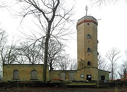
View from the west of the castle hill with the castle mountain tower |
||
| height | 155 m above sea level NHN | |
| location | at Gehrden ; Region Hannover , Lower Saxony ( Germany ) | |
| Mountains | Gehrdener Berg | |
| Dominance | 3.1 km → Benther Berg | |
| Notch height | 70 m | |
| Coordinates | 52 ° 18 '52 " N , 9 ° 35' 8" E | |
|
|
||
| rock | Shell limestone | |
| Development | Forest paths | |
| particularities | - Gehrdener Berg ring wall - Gehrdener Burgberg tower |
|
The castle hill is the northernmost and at about 155 m above sea level. NHN the highest elevation of the Gehrdener Berg ridge near Gehrden in the Hanover region of Lower Saxony . The ring wall system Gehrdener Berg and the Gehrdener Burgberg tower are located on it .
geography
location
The Burgberg rises in the northern part of the Gehrdener Berg. It is located in the urban area of Gehrden, the center of which extends directly to the east of the elevation. To the north-east lies Benthe on Benther Berg (approx. 173 m ) , north-north-east Everloh , north-north-west Ditterke and west-north-west Leveste ; they are all Gehrden districts. The southern neighbor is the Köthnerberg (approx. 136 m ). To the east and north, the landscape of the castle hill slopes down to the Haferriede , the water of which through the Möseke reaches the Südaue flowing northwest of the elevation , and to the west to the Levester Bach .
On Castle Hill are part of the protected landscape Gehrdener Berg ( CDDA -No 321,028;. 1968 reported, 8.5 square kilometers in size). It is wooded; the predominant tree species is the common beech .
Natural allocation
The castle hill belongs to the natural space main unit group Lower Saxony Börden (No. 52), in the main unit Calenberger Lößbörde (521) and in the subunit Hannoversche Börde (521.0) to the natural area Gehrdener Loesshügel (521.01).
Ring wall on the Gehrdener Berg
On the castle hill are the remains of a circular rampart, which used to be signposted as Cherus Castle , whose earlier function and dating are still the subject of research.
Burgberg Tower
On the crest of the Burgberg, an excursion restaurant with a 21 m high observation tower , the Burgbergturm, was built in 1897/98 by the Gehrden master bricklayer Krull , made from broken shell limestone. In 1898 Gehrden also received a tram connection to Hanover . Until the First World War, the restaurant was a popular destination for residents from the nearby cities of Linden and Hanover looking for relaxation .
The restaurant was sold and in 1924 it became a school camp of the Leibniz School Hanover . During the Second World War it served as a military hospital, then as refugee accommodation. The school was merged in 1945 with the then Herschel School in Hanover, which also had its own country home in Nienstedt , which the school was allowed to use again earlier. The country home on the Burgberg was also used until 1961, then dilapidated and sold in 1964 to the Hanoverian businessman Norbert Magis, who had part of the building demolished. In 1985 the building, which had fallen to the ground, came into the possession of the city of Gehrden, was repaired and made usable again as a lookout tower.
The Burgbergturm is open for two hours each two Sundays a month, otherwise by appointment. It is a listed building .
Infrastructure
Several forest and hiking trails lead around and over the castle hill, on the southern edge of which the Große Bergstraße crosses the Gehrdener Berg. The Matthias-Claudius-Gymnasium Gehrden is located on the lower part of its eastern slope .
Others
The city of Gehrden is also known as BurgBergStadt . In Gehrden there is the Burgbergschule , the Burgberg Apotheke and the newspaper burgbergblick , which appears in the Calenberger Land .
Individual evidence
- ↑ a b topographical map of the castle hill ( memento of the original from January 7, 2015 in the Internet Archive ) Info: The archive link was inserted automatically and has not yet been checked. Please check the original and archive link according to the instructions and then remove this notice. (DTK 25; see large enlargement of the map), on natur-erleben.niedersachsen.de
- ↑ Map services of the Federal Agency for Nature Conservation ( information )
- ↑ Ordinance on the Gehrdener Berg landscape protection area (LSG – H 24), accessed on January 3, 2015, on hannover.de (PDF, 42.94 kB)
- ↑ Burgbergturm , accessed on January 3, 2015, from gehrdener-ansichten.de
- ↑ The Herschels School - it existed before! ( Memento from April 25, 2016 in the Internet Archive ), accessed on January 4, 2015, from schulcms.de
- ↑ The Burgbergturm ( Memento from January 4, 2015 in the Internet Archive ), opening times of the Burgbergturm, accessed on January 4, 2015, at findcity.de
- ↑ Die BurgBergStadt Gehrden… ( Memento from January 4, 2015 in the Internet Archive ), accessed on January 4, 2015, on findcity.de
- ↑ School Association ( Memento from January 4, 2015 in the Internet Archive ) (including with Oberschule Gehrden ), accessed on January 4, 2015, at gehrden.de
- ↑ Burgberg Apotheke (Gehrden), accessed on January 4, 2015, at burgberg-apotheke.de
- ↑ burgbergblick , accessed on January 4, 2015, from burgbergblick.de


