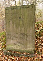
Ring wall on the Gehrdener Berg
The rampart on Gehrden hill is a ring wall on the Gehrden hill belonging Castle Hill in Gehrden ; the ring wall covers an area of around one hectare. So far, there is no reliable dating of the time of origin and use. It is assigned to the period between the birth of Christ and the early Middle Ages .
Location and building
The ring wall is located on the densely wooded crest of the castle hill at 155 meters above sea level as the highest point of the Gehrdener Berg. It measures 140 m × 75 m and encloses an oval area of around one hectare in a semicircle. The wall has been left out on the northwest side, as a steep slope offered protection. The wall and its ditch in front are still clearly visible in the area. The wall was only about 1.2 meters high. Since it had been piled up on the edge of the terrain and there was a ditch beneath it, the fortification looked visually imposing from the outside. The height difference between the crest of the wall and the bottom of the trench was up to five meters.
In 1897/98, a 20-meter high castle tower with an excursion restaurant was built within the ramparts, which began operating in 1899. At the beginning of the 20th century, both institutions were very attractive to residents of the nearby city of Hanover who were looking for relaxation . The restaurant was converted into a school camp of the Leibniz School in Hanover in 1924 and served as a military hospital during the Second World War . In 1961 the Hanoverian businessman Norbert Magis acquired the complex with the tower and restaurant. He had the tower restored, while the farm building fell into ruin.
Excavations
At the beginning of the 20th century, the prehistorian and castle researcher Carl Schuchhardt traced the complex and published it in the 1916 atlas of prehistoric fortifications in Lower Saxony. The first excavations took place in 1931, 1933 and 1937/38 at the instigation of the then regional archaeologist Karl Hermann Jacob-Friesen . During the excavations, a six-meter-wide wall with a pointed ditch up to four meters deep was found in the bedrock .
Although various finds such as ceramic shards from the time around the birth of Christ were made within the complex, the origin of the ramparts cannot be clearly assigned to this time. After the excavations, the Reich Labor Service laid out a Cherusker nature trail with explanatory stone tablets in the area of the ramparts in 1938 , which are still preserved. In 2015, the Hanover region set up an information board that provided information about the history and structure of the facility as well as its ideological appropriation during the National Socialist era .
In 2013, research into the ramparts on the Burgberg was resumed as a joint project of the Lower Saxony State Museum Hanover , the Institute for Prehistoric Archeology of the Free University of Berlin and the Lower Monument Protection Authority of the Hanover Region. After prospecting with soil samples in spring 2013, a three-week excavation took place in the summer of 2013 as a section through the wall, whereby no datable material could be recovered.
rating

After the excavations in the 1930s, the fortification was known as the Cheruscan castle and ascribed to the Germanic Cheruscan tribe . Today this genesis thesis is discarded, since no clearly datable material from the usage phase of the facility could be found and it matched the National Socialist ideology in the time of the Third Reich . Although there are a small number of finds from the Neolithic to the Middle Ages , they do not represent a reliable basis for dating. During the excavation in 2013, layers of soil with a darker and a lighter color were found, which indicate that the wall was in two phases originated.
The earlier function of the ring wall on Gehrdener Berg has not yet been clarified. For a long time, a fleeing castle was seen in it, such as the Kukesburg , the Heisterburg or the Wirkesburg as similar fortifications in the area. Recent considerations speak against a refuge on the Gehrdener Berg, since there is no water in the form of a spring or a stream. A possible function could have been the monitoring of the Hellweg passing by .
literature
- Georg Weber: The former Cheruskerburg with ramparts on the castle hill in: Heimatkundliche Blätter Stadt Gehrden , 1991
- Hans-Wilhelm Heine : The prehistoric and early historical castle walls in the administrative district of Hanover. Hannover 2000, ISBN 3-7752-5645-8 , pp. 100-101.
Web links
- Entry by Hans-Wilhelm Heine and Stefan Eismann on ring wall on Gehrdener Berg in the scientific database " EBIDAT " of the European Castle Institute
- Ringwall Gehrden in the Lower Saxony Monument Atlas
- Report on the excavation in 2013 in the Hanover newspaper ( Memento from April 21, 2016 in the Internet Archive )
- Burgberg - Gehrden sandstone. Brief description of the ramparts and the Burgberg tower at Hannover.de
- Brief description of the ramparts at the Heimatbund Gehrden
Individual evidence
- ↑ The wall on the castle hill poses a riddle. NDR.de from July 31, 2013 ( Memento from July 31, 2013 in the web archive archive.today ).
- ↑ The Cherusci were not the builders. ( Memento of the original from April 12, 2017 in the Internet Archive ) Info: The archive link was inserted automatically and has not yet been checked. Please check the original and archive link according to the instructions and then remove this notice. Hannover.de on April 15, 2015.
- ↑ Gehrdener Wall older than expected. Hannoversche Allgemeine Zeitung from July 31, 2013.
- ^ The ramparts were not a Cheruscan fortress. Hannoversche Allgemeine Zeitung from July 23, 2014.
Coordinates: 52 ° 18 '52.3 " N , 9 ° 35' 8.1" E


