Acrelândia
| Município de Acrelândia "Princesinha de Acre"
Acrelândia
|
||
|---|---|---|
|
|
||
| Coordinates | 9 ° 50 ′ S , 66 ° 53 ′ W | |
 Location of Acrelândia in the state of Acre Location of Acrelândia in the state of Acre
|
||
| founding | April 28, 1992 | |
| Basic data | ||
| Country | Brazil | |
| State | acre | |
| ISO 3166-2 | BR-AC | |
| Região intermediária | Rio Branco (since 2017) | |
| Região imediata | Rio Branco (since 2017) | |
| Mesoregion | Vale do Acre (1989-2017) | |
| Microregion | Rio Branco (1989-2017) | |
| height | 25 m | |
| climate | tropical, Aw | |
| surface | 1,807.9 km² | |
| Residents | 12,538 (2010) | |
| density | 6.9 Ew. / km² | |
| estimate | 15,256 Ew. (July 1, 2019) | |
| Parish code | IBGE : 1200013 | |
| Time zone | UTC -5 | |
| politics | ||
| City Prefect | Ederaldo Caetano de Sousa (2017–2020) | |
| Political party | Partido Socialista Brasileiro (PSB) | |
| economy | ||
| GDP | 211,982 thousand R $ 15,285 R $ per person (2015) |
|
| HDI | 0.604 (2010) | |
Acrelândia , officially Município de Acrelândia , is a small town in the Brazilian state of Acre . It is located in the far east of the state about a hundred kilometers east of the capital Rio Branco .
history
Settlement plans have been in place since the 1980s, infrastructure measures were taken, houses for colonists from the south were built, plots were determined and cocoa plantings were planted in the agricultural area. On April 28, 1992, it was raised to a separate community with the status of município by separating areas of the communities Plácido de Castro and Senador Guiomard .
The community had 12,538 inhabitants in the 2010 census, called Acrelandese. It ranks 15th in Acre by population and has the nickname Princesinha do Acre (the little princess Acres). According to the IBGE's estimate of July 1, 2019, the population was calculated to grow to 15,256 residents. The area was initially 1574.55 km² and, through further small area reforms, has meanwhile been 1807.948 km²; the population density is 6.9 people per km². The parish occupies 1.1% of the state's area.
In the north it forms a straight border with the states of Amazonas and Rondônia , in the east it is border area with Bolivia , with the Río Abuná forming the border river. Even further east, the terrain merges into the Beni lowland plain in Bolivia. Closest towns are Plácido de Castro in the southwest and Senador Guiomard in the west .
Together with the municipalities of Bujari , Capixaba , Plácido de Castro , Porto Acre , Rio Branco and Senador Guiomard , it has formed the geostatistical Região geográfica imediata Rio Branco since 2017 , which in turn forms the Região geográfica intermediária Rio Branco with the regions Brasileia and Sena Madureira .
City administration
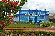
After the local elections in 2016, city prefect (executive) is Ederaldo Caetano de Sousa des Partido Socialista Brasileiro (PSB) for the 2017 to 2020 term of office , the legislature lies with the Câmara Municipal, the city council. The place is also the seat of the district of the same name.
traffic
Coming from the southwest of Rio Branco, the BR-364 leads north through Acrelândia with a customs post to Rondônia and there further southeast to São Paulo.
Web links
- Acrelândia website on cidade-brasil.com (Brazilian Portuguese)
- Governo do Acre: Acre em números 2017. Secretaria de Estado de Planejamento - SEPLAN, Rio Branco 2017. (Contains statistical information; Brazilian Portuguese).
Individual evidence
- ↑ Climate data . Retrieved September 12, 2018.
- ↑ a b c IBGE : Acre - Municípios - Acrelândia - Panorama. Retrieved September 12, 2018 (Brazilian Portuguese).
- ↑ Eleições 2016: Catetano 40 on the website www.eleicoes2016.com.br . Retrieved September 12, 2018 (Brazilian Portuguese).
- ↑ IBGE: Acrelândia: História , historical summary. Retrieved September 12, 2018 (Brazilian Portuguese).


