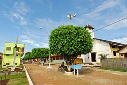
Marechal Thaumaturgo
| Município de Marechal Thaumaturgo Marechal Thaumaturgo |
||
|---|---|---|
|
Marechal Thaumaturgo on the Rio Amônea
|
||
|
|
||
| Coordinates | 8 ° 56 ′ S , 72 ° 47 ′ W | |
 Location of Marechal Thaumaturgo in the state of Acre Location of Marechal Thaumaturgo in the state of Acre
|
||
| founding | April 28, 1992 | |
| Basic data | ||
| Country | Brazil | |
| State | acre | |
| ISO 3166-2 | BR-AC | |
| Região intermediária | Crueiro do Sul | |
| Região imediata | Cruzeiro do Sul | |
| structure | 1 multiple district | |
| height | 245 m | |
| Waters | Rio Juruá , Rio Amônea | |
| climate | tropical, Aw | |
| surface | 8,191.7 km² | |
| Residents | 14,227 (2010) | |
| density | 1.7 Ew. / km² | |
| estimate | 18,867 (July 1, 2019) | |
| Parish code | IBGE : 1200351 | |
| Time zone | UTC −4, −5 | |
| politics | ||
| City Prefect | Isaac da Silva Piyãko (2017-2020) | |
| Political party | PMDB | |
| Culture | ||
| Patron saint | Saint Sebastian | |
| City festival | April 28 | |
| economy | ||
| GDP | 163,140 thousand R $ 9656 R $ per person (2015) |
|
| HDI | 0.501 (2010) | |
Marechal Thaumaturgo , officially Portuguese Município de Marechal Thaumaturgo , is a small town with a very large municipality in the state of Acre in northwestern Brazil . The total population as of July 1, 2019 was estimated at 18,867 inhabitants , who live in an area of around 8,191.7 km² with a population density of 1.7 inhabitants per km². They are called Thaumaturguenser (Portuguese thaumaturguenses ). Only around 4,000 people inhabit the urban area, the rest of the population, including 1,750 indigenous peoples live in 18 forest villages, the aldeias , in the Amazon rainforest and along the numerous rivers (as of 2015). The distance to the capital Rio Branco is 557 km. The place lies at the confluence of the Rio Amônea in the Rio Juruá .
Origin of name
The name of the community goes back to Marshal Gregório Taumaturgo de Azevedo (1896–1979). Contrary to the newer Portuguese spelling, the older form with Thaumaturgo was retained.
geography
The municipality of Porto Walter borders in the north, the municipality of Senador Guiomard in the northwest and the municipality of Jordão in the east . The southern and western municipal area forms a green border with Peru .
Terras indígenas
The municipality contains two Indian sanctuaries in which Huni Kui (Kaxinawá), Ashaninka, Jaminawa-Arara, Kuntanawa and Apolima-Arara live. Most of the area is occupied by the Reserva Extrativista do Alto Juruá usable reserve .
City administration
Prefect (mayor) is since the local elections in Brazil in 2016 the Ashaninka Isaac Piyãko, brother of the active also in Marechal Thaumaturgo and Acre Indigenous leader Benki Piyãko .
literature
- Secretaria de Estado de Planejamento - SEPLAN, Governo do Estado do Acre: Acre em números 2017 . Rio Branco 2017 (Brazilian Portuguese, acreemnumeros.com [PDF] See also previous editions).
Web links
- Município de Marechal Thaumaturgo, Acre. In: com.br. www.cidade-brasil.com.br, accessed March 20, 2018 (Portuguese).
Website addresses of the city prefecture and city council are currently (2018) unknown.
Individual evidence
- ↑ Climate Marechal Thaumaturgo: Weather, average temperature, weather forecast for Marechal Thaumaturgo. In: climate-data.org. de.climate-data.org, accessed on October 7, 2018 .
- ↑ IBGE : Cidades @ Acre: Marechal Thaumaturgo. Retrieved September 9, 2019 (Brazilian Portuguese).
- ↑ IBGE : Marechal Thaumaturgo - Panorama. Retrieved October 7, 2018 (Brazilian Portuguese).
- ↑ IBGE : Marechal Thaumaturgo - História. Retrieved March 20, 2018 (Brazilian Portuguese).
- ↑ Isaac Piyãko 15 (Prefeito). In: com.br. Eleições 2016, accessed October 7, 2018 (Brazilian Portuguese).
- ↑ Índio ganha prefeitura no AC e diz ter sofrido preconceito em campanha . In: O Globo . October 3, 2016 (Brazilian Portuguese, globo.com [accessed March 19, 2018]).


