
Lauenstein (Salzhemmendorf)
|
Lauenstein
Patches Salzhemmendorf
|
||
|---|---|---|
.png) |
||
| Height : | 163 (140-233) m | |
| Area : | 14.64 km² | |
| Residents : | 1946 (Jun. 30, 2016) | |
| Population density : | 133 inhabitants / km² | |
| Incorporation : | 1st January 1973 | |
| Postal code : | 31020 | |
| Area code : | 05153 | |
Location of Lauenstein in Lower Saxony |
||

Lauenstein is a district of the borough Salzhemmendorf in Lower Saxony Hamelin-Pyrmont district and has about 2,100 inhabitants.
geography
Lauenstein lies in the Weserbergland , not far from the only deeper depression in the ridge of the Ith ridge , in a valley that slopes eastwards across the Ith ridge . Part of the more recent development extends beyond the valley to the eastern slopes of the Ith and into the Saale valley.
history
Fiefdom

Lieutenants in the area of the office were the noblemen of Homburg , who ruled from 1152 to 1409. Their seat was the Homburg near Eschershausen . The Counts of Spiegelberg were also feudal lords from 1152 to 1557. They sat at Spiegelberg Castle and later at Coppenbrügge Castle . Another important feudal lord was Bock von Nordholz , who sat at Nordholz Castle in Nordholz am Osterwald .
middle Ages
Around 1215, Count Bernhard von Poppenburg built Spiegelberg Castle and has been called Count Bernhard von Spiegelberg ever since. The fall of Spiegelberg Castle was reported in 1226, when the noble lords of Homburg from Stadtoldendorf fought for the territory of Bernhard von Spiegelberg and were able to unite it as a bailiwick with their dominion of Homburg. Bernhard had to leave the country on the orders of the emperor. Above today's village of Lauenstein, the Homburgers probably built Lauenstein Castle as the new "Castrum Lewenstein" in the 13th century . It was first mentioned as such in 1247, when Heinrich von Homburg transferred the castle to the Guelph Duke Otto and received it back as a fief. Shortly afterwards, residents from villages that had fallen desolate later settled in the shelter of the castle.
In 1359, the Homburg office Lauenstein with 40 villages in the area between Ith , Hils and Leine was first mentioned in a document. The last descendant of the Homburgers died in 1409 and bequeathed the castle to the Guelph dukes of Braunschweig-Lüneburg. The Spiegelbergers, who had meanwhile returned to Coppenbrügge , wanted to bring back their former possessions. During the feuds , Wallensen , a district of Salzhemmendorf , was completely destroyed.
In 1430 the Lauenstein patch was first mentioned in a document. In 1433, the dukes of Braunschweig-Lüneburg pledged Lauenstein Castle to the diocese of Hildesheim due to financial difficulties , which it subsequently to the von Cramm brothers in 1434, Ludolf von Ruscheplate in 1445, the Bock brothers von Nordholz in 1456, Bartold of Oberg and the Knights Brothers from rods mountains in 1495, Heinrich von Saldern in 1497 and Burchard of Saldern in 1515 afterverlehnte .
Modern times
.jpg)
1518 conquered the Hildesheim Bishop Johannes IV. Von Sachsen-Lauenburg the Burg Lauenstein . As a result, Burchard was driven out by Saldern and the Burgflecken burned down. The bishop appointed a bailiff from Hildesheim as his successor . The power-political approach of the bishop resulted in the Hildesheim collegiate feud .
The dukes of Braunschweig-Lüneburg retook Lauenstein in 1521 and reinstated Burchard von Saldern as lord of Lauenstein. In 1550, after the death of his father, Heinrich von Saldern took over Lauenstein. This split with the dukes of Braunschweig-Lüneburg in 1587. He was then removed from office and expelled. As a result, officials were appointed as administrators at Lauenstein Castle. 1590 Lauenstein was Duke Heinrich Julius the market rights granted.
After Lauenstein Castle was destroyed as a result of the Thirty Years War , the official residence was temporarily relocated to the nearby Eggersen domain in 1709 . In 1716 Christian Eberhard Niemeyer came to Lauenstein as the successor to Johann Halberstadt († October 31, 1725 in Hemmendorf), where he worked as a bailiff for over 50 years. On October 20, 1730, the place burned down due to the negligence of a baker. The reconstruction, using stones from Lauenstein Castle above, took three years. In 1737, bailiff Niemeyer bought the grounds of the outer bailey , the Knabenburg , and farmed there until 1850. At the beginning of the 19th century, the decaying Lauenstein Castle was demolished.
In 1852 Lauenstein received a district court .
On January 1, 1973 Lauenstein (Flecken) was incorporated into Salzhemmendorf with the then official community key 03134162. The former municipality of Lauenstein (Flecken) had an area of 14.64 km².

religion
The historic St. Nikolai Church on Im Flecken is part of the Evangelical-Lutheran community association Saale Valley. The community association also operates the daycare center Villa Kreibaum on Mühlenstrasse.
The Catholic St. Benedict Church was built on Dahlienweg in 1961, after which a Catholic parish had formed in Lauenstein in the post-war period. In 1968 she got the now profane branch church in Coppenbrügge . Since 2006 the Catholics in Lauenstein belong to the parish of St. Joseph in Gronau .
On the cemetery on the road to Hemmendorf is the St. Anne's Chapel , also called Spiegelberger Chapel (see sights).
politics
Local council
Lauenstein has a local council of nine.
The local mayor of Lauenstein is Erich Weber (SPD).
coat of arms
In the split shield on the left the entwined golden letters L and S on a blue background, on the right half a golden heraldic lily on a red background and on the right and left above and in the middle below each a gold star. The letters L and S mean Lauenstein. The von Cramm brothers, who were lords of Lauenstein Castle from 1434–1445, had a lily on their coat of arms. The halved coat of arms probably indicates that the Lauensteiners were subjects of the lords of the castle, but that the town had its own administration (mayor and council). The three stars are said to have been added under Duke Erich I of Calenberg (1495–1540), who was allowed to put a star over his coat of arms as a thank you to the emperor for saving his life.
Culture and sights

Colored postcard around 1900
At the beginning of the 19th century, Lauenstein Castle was demolished due to increasing deterioration. Today it is a ruined castle.
The St. Anne's Chapel is one of the oldest churches in the district, today it is a cemetery chapel. The tower was built around 1126 and the first nave around 1162. The choir was built in 1464. There is an inscription in Gothic lowercase letters above the tracery of the choir window . The chapel has an altar with a former reliquary grave and consecration crosses . An old piscina is in the east wall. There were formerly two galleries that were removed as part of a renovation in 1954. In the church tower, which is covered with stone slabs from the Solling , is the bell Madonna vom Spiegelberg from 1695.
The Ith Tower offers a view of the region. There is also a natural adventure pool in Lauenstein.

St. Anne's Chapel
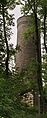
Ith Tower near Lauenstein

Ruins of Lauenstein Castle


Economy and Infrastructure
In addition to agriculture, wool was spun from home for the Hamelin weaving mill from 1780 onwards . Numerous residents worked for the prefabricated house group OKAL founded by Otto Kreibaum , which had its headquarters and the plant for Lower Saxony in Lauenstein until 2005. There is a model home here. From 1896 to 1967 the place was connected to the passenger and freight traffic of the Voldagsen – Delligsen railway .
Personalities
- Conrad Werner Wedemeyer (1662–1732), governor and landowner
- Ernst Rudorff (1840–1916), composer, music teacher and nature conservationist in Lauenstein
- Otto Kreibaum (1902-1985), entrepreneurs, founder of OKAL ( O tto K reibaum A us L Auenstein )
Web links
Individual evidence
- ^ Margret Zimmermann, Hans Kensche: Castles and palaces in Hildesheimer Land. 1st edition. Hildesheim: Lax, 1998, ISBN 3-8269-6280-X , p. 95.
- ^ The History ( Memento of September 29, 2007 in the Internet Archive )
- ^ Federal Statistical Office (ed.): Historical municipality directory for the Federal Republic of Germany. Name, border and key number changes in municipalities, counties and administrative districts from May 27, 1970 to December 31, 1982 . W. Kohlhammer GmbH, Stuttgart and Mainz 1983, ISBN 3-17-003263-1 , p. 195 .
- ↑ Federal Statistical Office: Official register of municipalities for the Federal Republic of Germany with overviews of the administrative structure and information on the affiliation of the municipalities to local classes, postcode areas and some important administrative units. 1957 edition, p. 159
- ↑ Local election 2011 Lauenstein ( Memento of the original from March 25, 2016 in the Internet Archive ) Info: The archive link was automatically inserted and not yet checked. Please check the original and archive link according to the instructions and then remove this notice.
- ↑ Flyer Politics in Flecken Salzhemmendorf (PDF)
- ↑ Explanatory board at the entrance to St. Annenkapelle

Ahrenfeld | Benstorf | Hemmendorf | Lauenstein | Levedagsen | Ockensen | Oldendorf | Osterwald | Salzhemmendorf | Thüst | Wallensen