
Me
| Me | ||
 Ihme near the southern city limits of Hanover |
||
| Data | ||
| Water code | DE : 48876 | |
| location | Region Hannover , Lower Saxony ( Germany ) | |
| River system | Weser | |
| Drain over | Leine → Aller → Weser → North Sea | |
| source | near Evestorf from Wennigser Mühlbach and Bredenbecker Bach 52 ° 16 ′ 30 ″ N , 9 ° 37 ′ 16 ″ E |
|
| Source height | approx. 68 m above sea level NHN | |
| muzzle | in Hanover in the Leine coordinates: 52 ° 22 ′ 38 ″ N , 9 ° 42 ′ 45 ″ E 52 ° 22 ′ 38 ″ N , 9 ° 42 ′ 45 ″ E |
|
| Mouth height | approx. 48 m above sea level NHN | |
| Height difference | approx. 20 m | |
| Bottom slope | approx. 1.3 ‰ | |
| length | 16 km | |
| Catchment area | 111.11 km² | |
| Left tributaries | Weetzener Graben, Hirtenbach | |
| Right tributaries | Holtenser Bach, Hemminger Maschgraben , Seniebach , Schneller Graben | |
| Big cities | Hanover | |
| Medium-sized cities | Ronnenberg | |
| Communities | Wennigsen (Deister) | |
| Residents in the catchment area | 500,000 | |
| Navigable | Faster digging to the line | |
 Rivers in the inner city of Hanover |
||
The Ihme is an approximately 16 km long left tributary of the Leine in Lower Saxony . From the confluence of the Schnellen Graben in Hanover (Leine km 17.31) to the confluence with the Leine (km 20.89), the Ihme is a federal waterway for which the Braunschweig Waterways and Shipping Office is responsible.
River to Schnellen Graben
The Ihme forms in the eastern Deist foreland near the village of Evestorf . The flowing water receives an inflow from the Wennigser Mühlbach coming from the west and from the Bredenbecker Bach, the Beeke, coming from the south-west . From there the Ihme flows first in an east-northeast direction. At the confluence of the two streams, the Evestorf local council and the Wennigsen v. In 1896 the "Ihmestein" was built as a tourist landmark. The coat of arms of Evestorf shows the Ihme with its two source rivers. Before the limestone railway was built along the Bredenbeck brook at the end of the 19th century, the confluence was still well east of the Hamelner Chaussee .
The Ihme gives its name to the village of Ihme, southwest of Hanover , which, together with the village of Roloven, forms the Ronnenberg district of Ihme-Roloven .
After six kilometers the Ihme reaches the Hanoverian district of Ricklingen . There it flows partly along steep banks in several turns through the Ricklinger Holz and then past the Ricklinger gravel ponds and the Ricklingen outdoor pool. Here in the northern part of the Great Ricklinger Pond, the Seniebach drains the Ricklinger Kiesteiche into the Ihme. A river dike protects Ricklingen from flooding. In Ricklingen the Ihme is traditionally referred to as "Beeke" (see the local Beekestrasse ).
From the confluence of the Holtenser Bach to the Ricklinger Holz, the Ihme marked the border between the offices of Koldingen and Calenberg . The stretch of water was named Landwehr . On the Landwehr, or rather the Ihme, there were four watermills at Vörie , Bettensen , Kückenmühle and Ricklingen.
The maintenance of the Ihme is incumbent on the entertainment association 52 “Mittlere Leine” up to the confluence of the Schnell Graben .
The Ihme in the area of Calenberger Neustadt and Linden
At the height of the Hanover – Altenbeken railway line (at the intersection of the Hanoverian districts of Ricklingen, Linden-Süd and Calenberger Neustadt ), the Schnelle Graben flows into the Ihme, the drainage of which is thus increased many times over. The Schnell Graben begins in the middle of the Maschsee and takes a considerable part of its water from the line. It was mentioned in a document as early as 1449 as Snellegrave .
When there is a flood , most of the water from the Leine is channeled into the Ihme to protect downtown Hanover from flooding . For this purpose, the river bed of the Ihme lies between the Schneller Graben and its mouth within a flood ditch (there is a large open area on at least one, usually on both sides of the normal river bed), whose capacity allows even very strong floods to be discharged.
When the Maschsee was built from 1934 to 1937, Ihme straightening was also carried out. The previous arch around the Lindener Aue disappeared and the new Schützenplatz was created on the acquired site . The river Ihme between the confluence of the Schnellen Graben and the bridge on the Black Bear was straightened slightly to the west and received higher dikes. The Legion Bridge and the Stadium Bridge were also built at that time. The Schröder and Thießler bathing establishments in the Ihmebogen, the military bathing establishment and the Hanoverian rowing club from 1880 lost their places. The course of the river in this area was shortened by 600 m to 1,700 m and the runoff speed tripled in the event of a flood.
In order to further improve flood protection in the event of a flood of the century , the Benno-Ohnesorg Bridge was demolished from 2008 to 2012 and replaced by a 20 m longer structure. By excavating the bank areas below and above the bridge, but only on the eastern bank, the possible flow rate of the Ihme was significantly increased during flooding. Residents united in a citizens' initiative protested against the felling of numerous trees on the east bank between the Benno-Ohnesorg Bridge and the Leinert Bridge associated with this construction project . The newly designed green area is heavily used today.
In the district Linden Center of Ihme in the 1970s in the style of was on the banks Brutalism the Ihme-Zentrum built. To the north of this is the Linden thermal power station , which generates electricity and district heating . To the north of the districts of Linden-Nord and Calenberger Neustadt , the river Ihme joins the Leine at the so-called "Leinedreieck". This place is known primarily in Hanover as the Fährmannseck, where the Hanover Ferryman Festival takes place regularly .
shipping
The inflow of the Leinewasser over the Schnellen Graben turns the Ihme from a small river into a navigable waterway. In connection with the Leine, the connecting canal to the Leine and the Hannover-Linden branch canal, there is a connection to the Mittelland Canal . This scenic route through Hanover is mainly used by excursion boats and sports boats.
The Ihme is a popular area for rowing in Hanover, below the tributary of the Schnellen Graben. The water is used by three rowing clubs ( Angaria , DRC, rowing club Linden). Several commercial providers offer canoe rental from the Schnellen Graben, from which the Ihme is often used. The upper course of the Ihme above this trench is not passable.

Ihmestein in Evestorf at the confluence of the Wennigser Mühlbach and Bredenbecker Bach to the Ihme

Water column at the crossing of the Green Ring Hanover over the Ihme near Devese
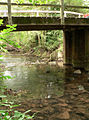
Him bridge at Devese

Flood of the Ihme at the Ihme center

Ihme mouth in the leash (leash coming from the right)


literature
- Flood protection in Hanover (brochure), Building Department Hanover (in cooperation with the press and public relations department in the mayor's office), Hanover, May 2008
- Waldemar R. Röhrbein (Ed.): The Maschsee in Hanover. Its origins and history , with contributions by Ernst August von der Haar u. a., Hannover: Schlüter, 1986, ISBN 3-87706-046-3 .
- Waldemar R. Röhrbein : Fast digging. In: Klaus Mlynek, Waldemar R. Röhrbein (eds.) U. a .: City Lexicon Hanover . From the beginning to the present. Schlütersche, Hannover 2009, ISBN 978-3-89993-662-9 , p. 547 f.
- Julie Schröder: "The use and structural change of the Leineaue south of Hanover in the late 19th and 20th centuries", master's thesis in history, University of Hanover, 2001.
- Fritz Klein: "Stinking from the flax rotting of the residents". Ihme's picture of life. In: Armin Mandel (Hrsg.): Heimatbuch 1 - Menschen und Landschaft um Hannover , Th. Schäfer, Hannover 1983, ISBN 3-88746-087-1 , pp. 56–59
Web links
- Ihme , description on hannover.de
- Leine- and Ihmeufer , information about Hanover's green spaces and parks along the Ihme, at hannover-park.de
Individual evidence
- ↑ a b Map services of the Federal Agency for Nature Conservation ( information )
- ^ Area directory for the Lower Saxony hydrographic map. Update as of July 13, 2010 (PDF; 599.8 KB). www.umwelt.niedersachsen.de, accessed on January 8, 2016 .
- ↑ Lengths (in km) of the main shipping lanes (main routes and certain secondary routes) of the federal inland waterways ( memento of the original from January 21, 2016 in the Internet Archive ) Info: The archive link was inserted automatically and has not yet been checked. Please check the original and archive link according to the instructions and then remove this notice. , in lengths of the federal waterways , Federal Waterways and Shipping Administration, on wsv.de
- ↑ Watercourses that are wholly or partly an inland waterway of the federal government serving general traffic (basis: directory E) , Ser. No. 28 ( Memento of the original from September 16, 2016 in the Internet Archive ) Info: The archive link was inserted automatically and has not yet been checked. Please check the original and archive link according to the instructions and then remove this notice. in chronicle about the legal status of the federal imperial waterways / inland waterways in the territory of the Federal Republic of Germany after October 3, 1990 , p. 115, p. 5 (status: February 2013), Federal Waterways and Shipping Administration, on wsv.de (PDF ; 1.32 MB)
- ↑ a b Topographical Atlas of the Kingdom of Hanover and the Duchy of Braunschweig by August Wilhelm Papen sheet PA048 , JPG (5´3.51 MB) in reduced resolution free of charge in the LGLN Internet shop; Retrieved November 26, 2016
- ^ Günter Gebhardt: Military affairs, traffic and economy in the middle of the electorate and kingdom of Hanover 1692-1866 . ibidem-Verlag / ibidem Press, ISBN 978-3-8382-6184-3 ( google.de ).
- ^ Waldemar R. Röhrbein: Fast digging. In: Stadtlexikon Hannover, pp. 547f.
- ↑ The brochure Flood Protection in Hanover (see literature) indicates the 17th century on p. 8: {Quote | The "Rapid Ditch" was built as early as the 17th century}
- ↑ Hanover city map from March 1931. Retrieved on July 31, 2019 .
- ↑ Julie Schröder's thesis, p. 72
- ↑ Waldemar R. Röhrbein "Der Maschsee", pp. 70–71
- ↑ Julie Schröder's thesis, pp. 82–83
- ^ Benno-Ohnesorg Bridge. For more flow. hannover.de, archived from the original on May 26, 2011 ; Retrieved May 26, 2011 .