Wennigser Mühlbach
| Wennigser Mühlbach | ||
|
Mühlendammweg with a bridge over the mill operating ditch |
||
| Data | ||
| location | Wennigsen ; Region Hannover , Lower Saxony ( Germany ) | |
| River system | Weser | |
| Drain over | Ihme → Leine → Aller → Weser → North Sea | |
| Headwaters | in the Deister below the Bröhn | |
| muzzle | near Evestorf in the Ihme coordinates: 52 ° 16 ′ 30 ″ N , 9 ° 37 ′ 16 ″ E 52 ° 16 ′ 30 ″ N , 9 ° 37 ′ 16 ″ E |
|
| Mouth height |
70 m above sea level NHN
|
|
| length | approx. 8 km | |
| Left tributaries | Bruchbach | |
| Right tributaries | Waldkaterbach | |
| Communities | Wennigsen | |
|
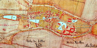
Wennigser Mühlbach with artificial mill operating ditch (1751) |
||
The Wennigser Mühlbach is a flowing water in the municipality of Wennigsen and the orographic left of the two source waters of the Ihme in the Hanover region of Lower Saxony . Its inner course in the center of Wennigsen is a listed building. Two bridges crossing it and a weir are also on the list of recognized architectural monuments.
course
According to Friedrich Wüllner's local history, old tunnels in the Deister are considered to be the sources of the Mühlbach. He also names three source areas in the Deister: the upper one extends to the Tellerkurve, the middle to the Nachtflügelweg and the lower source area up to an altitude of about 120 m above sea level. NHN . The tributaries meet at the level of the forest sports field, east of the village of Waldkater. From there the stream flows along the water park , the Wennigsen monastery to the Knölkenbrücke. There it reaches the Sorsum and Evestorf districts east of Wennigsen . Southwest of Sorsum it takes on the Waldkaterbach from the right, before it forms the origin of the Ihme together with the Bredenbecker Beeke, also coming from the right, northwest of Evestorf.
At the western edge of Wennigsen's location, the Mühlenbetriebsgraben branches off to the right from the Mühlbach. From there on, the Mühlbach flows almost completely covered by Wennigsen before it comes to light again east of the fire station.
Mill operating ditch
| Mill operating ditch | ||
|
View of the lower mill pond |
||
| Data | ||
| location | Wennigsen ; Region Hannover , Lower Saxony ( Germany ) | |
| River system | Weser | |
| Drain over | Mühlbach → Ihme → Leine → Aller → Weser → North Sea | |
| Junction | on the street Am Wehr from the Mühlbach 52 ° 16 ′ 16 ″ N , 9 ° 33 ′ 43 ″ E |
|
| muzzle | east of Wennigsen monastery in the Mühlbach
|
|
| length | approx. 1 km | |
| Communities | Wennigsen | |
The Mühlbach is listed as an ensemble in the inner city of Wennigs. Next to it runs an artificially created mill operating ditch, which is fed by the water of the brook and branches off at the western edge of Wennigsen. In former times there were seven Wennigs mills with mill ponds in front of it (see map). These served as water storage for the mill operation in the summer months. As a monument, the Obere Mühle still stands today as a former wood sawmill and today's Wennigsen local history museum, as well as the Wennigsen middle mill as two of three overshot water mills . The third, also known as the Lower Mill or Klostermühle , was demolished in 1960. In their place there is now a residential building. A cascade was built at the point where the mill wheel was . Shortly after the garden of Wennigsen Monastery, the mill operating ditch flows into the Mühlbach.
In contrast to the Mühlbach, which was covered over a longer stretch within Wennigsen, the Mühlenbetriebsgraben flows almost along its entire length on the surface. Apart from underpasses under streets, longer sections are only piped when crossing under the Mühlenstraße, which has been expanded into a square at this point, the fire station and the Klosteramthof street and the adjacent monastery wall.
Architectural monuments
Two listed bridges can be found in the course of the Mühlbach not far from the Wennigsen monastery. One is in the monastery garden, one in the monastery courtyard. There is also the beginning of the Mühlendammweg and a protected weir at the mill operating ditch.
To the west of the village of Sorsum is another bridge over the Mühlbach, which has been registered as a monument. This arch bridge was built from natural stone blocks in the middle of the 19th century. Today state road 391 leads over this bridge from Wennigsen to Sorsum.
In the course of the planning for the Hanover Garden Region project, the inner-city area was revised by a landscape planning office. New lighting systems were installed, hydrangea beds laid out and the historical character emphasized, for example, by exposing natural stone profiles.
literature
- Friedrich Wüllner: From Wennigsen's past / contributions to local history . Self-published Wennigsen, 1973, pp. 124–126.


