Dusseldorf
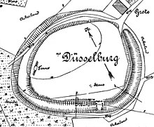
The Düsselburg was an early medieval ring wall , the remains of which are located near Rehburg in Lower Saxony . The Wallburg on a hillside probably served the population as a refuge castle and dates from the 8th to the 10th century.
location
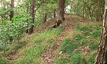
The former fortification is located in the open area on a plateau-like elevation about 3 km northwest of Rehburg. It is located on the slope of a foothill of the sandy Kiebitzberg range of hills. A bend in the Meerbach , which ran past about 50 m to the southwest, offered the Düsselburg natural protection. The ramparts are now covered with trees and can be seen from afar. The interior is used as grazing land for livestock.
description

The earth ring wall of the fortification is still there today. It forms an oval of 150 × 120 m. The wall is about 1 m high and up to 10 m wide. There used to be a berm in front of it . The upstream ditch was 5 m wide and 1.5 m deep. In front of it there was another fortification by a wall, which was made of palisades . The access found during the excavation on the south side consisted of a gate chamber in the wall, which was 7 m wide and long. A layer of fire indicated that the gate had once burned down and then rebuilt. The gate area continued inside through paving in the floor. The Düsselburg was declared a cultural monument in 1958 .
Research history
An archaeological excavation of the ramparts was carried out in 1904 by the castle researcher Carl Schuchhardt , who carried out numerous excavation cuts in the rampart, ditch and interior. The investigations inside the ramparts revealed plenty of traces of settlement, such as pits with ceramic residues, iron slag and iron parts. There were also post holes in buildings. Many finds were made in the pre-Roman Iron Age of the 1st to 4th centuries BC. Dated. Early medieval ceramic shards around the 10th century indicated the end of use of the facility.
In 2018, geophysical prospecting measures were carried out by the municipal archeology of the Schaumburg landscape and students of the University of Göttingen . Due to the airborne laser scanning in Lower Saxony, the Lower Saxony State Office for Monument Preservation has LiDAR images of the system that show the actual terrain without the tree belt on the wall. In 2018, as part of their investigations, archaeologists again sighted the 30 kg ceramic material recovered at the beginning of the 20th century.
Use and development interpretation
Due to the way it was built, the remains of the complex that are visible today are classified as being in the 8th to 10th centuries. Because of the structure, a refuge for the population in times of danger comes into question as a function of the ramparts . Finds from the 1st to 4th centuries BC point to an earlier use of this elevated and striking point of the terrain. Chr. It is unclear whether a fortification already existed at this early point in time.
In the historical tradition there is a documentary mention of Düsselburg in 1207 in connection with the Mariensee monastery . According to this, there was a mill and three houses here. The fortifications were probably already unused at that time.
Similar fortifications in the vicinity
- In the plane:
- Isenburg near Barsinghausen -Landringhausen
- Lüningsburg near Neustadt am Rübenberge
- In height:
- Heisterburg near Lauenau - Feggendorf
- Wirkesburg near Lauenau-Feggendorf
- Barenburg near Eldagsen
- Heisterschlösschen near Beckedorf
- Kukesburg near Springe -Altenhagen
- Bennigser Castle near Bredenbeck- Steinkrug
- Sachsenwall near Nordstemmen
Fortifications of this kind were originally regarded as Saxon or Heinrichsburgen by archaeological research . The more recent research assigns the structures in the area of the Central Weser and the Leine to a period from the 8th to the 12th century. Due to the lack of settlement, the facilities are likely to have only been used sporadically and have served as refuges. In the case of the facilities in the Deister area (Wirkesburg, Bennigser Burg, Heisterschlösschen) it is typical that they were built on sloping mountain ridges and near a stream.
literature
- Hans-Wilhelm Heine : The Düsselburg near Rehburg . In: Guide to Prehistoric and Protohistoric Monuments. Volume 49. Part II Excursions . Mainz 1981
- Hans-Wilhelm Heine: The prehistoric and early historical castle walls in the district of Hanover , 2000, Hanover, ISBN 3-7752-5645-8 , pp. 141-143.
Web links
- Entry by Stefan Eismann zu Düsselburg in the scientific database " EBIDAT " of the European Castle Institute
- Düsselburg in: Castles around 1000 between Mittelweser and Leine (PDF, 500 kB)
Individual evidence
- ↑ Pray Ney-Jansen: Rehburg's oldest settlement in Die Harke from December 4, 2018
- ↑ New findings about Rehburg's oldest settlement in Blickpunkt from December 6, 2018
Coordinates: 52 ° 29 ′ 6.6 " N , 9 ° 10 ′ 58.4" E


