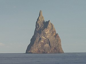
Ball's pyramid
| Ball's pyramid | |
|---|---|
| Ball's pyramid | |
| Waters | Tasman Sea |
| Archipelago | Lord Howe Archipelago |
| Geographical location | 31 ° 45 ′ 15 ″ S , 159 ° 15 ′ 5 ″ E |
| length | 1.1 km |
| width | 300 m |
| surface | 20 ha |
| Highest elevation | Ball's Pyramid 562 m |
| Residents | uninhabited |
Ball's Pyramid is an uninhabited rocky island about 600 kilometers east of mainland Australia in the Tasman Sea . It belongs to the Australian Lord Howe Archipelago and is located around 20 kilometers southeast of Lord Howe Island , the main island of the group .
geology
The island, measuring almost 1100 × 300 meters, consists mainly of an imposing, 562 m high rock in the form of a pyramid . Ball's Pyramid is the remnant of a shield volcano about seven million years old ; the island and some of the smaller islets immediately surrounding it (such as Observatory Rock , Wheatsheaf Islet and Southeast Rock ) are part of the Lord Howe Island Marine Park .
history
The rocky island was discovered in 1788 by the British naval officer Henry Lidgbird Ball during the sighting of the much larger neighboring Lord Howe Island. The first ascent of the rock took place on February 14, 1965 by an Australian rope team from Sydney . Climbing on Ball's Pyramid has been banned since 1982 . During an expedition on Ball's Pyramid in 2000/2001, a large species of ghost , the so-called tree lobster , which had long been considered extinct , was rediscovered.
Web links
- Ball's Pyramid on Peakbagger.com (English)
- World Mountain Encyclopedia - Ball's Pyramid
- Jack Pettigrew's climbing page (English)
- Ball's Pyramid near Oregonstate (English)


