
Lord Howe Island Marine Park
The Lord Howe Iceland Marine Park , located 700 km north-east of Sydney and surrounds the Lord Howe Island Group and Ball's Pyramid . The largest protected ocean area of New South Wales consists of two state waters, Lord Howe Island Marine Park (State Water) with 3,000.63 km² and Lord Howe Island Marine Park (Commonwealth) with 465.45 km². The parks are part of the UNESCO World Heritage .
geography

The islands in the marine reserve are the mountain peaks of a 1,000 km long submarine mountain range, which protrude from a 1,800 meter deep plateau above the water and which were formed as a result of volcanic activity in the late Miocene .
The sanctuary, administered by New South Wales, encompasses the islands three nautical miles of ocean, which are joined by the protected waters of the Commonwealth for a distance of 200 nautical miles.
history
It is believed that the Lord Howe Archipelago was first sighted by British colonists on the HMS Supply when they sailed from Sydney to Norfolk Island . The first landing on this island took place two months later on the return voyage.
In the 1830s, residents settled on Lord Howe Island , who made a living from hunting, fishing and the fruits growing there, and who traded with the whalers. The traditions and the lifestyle of the islanders were determined by the influence of the marine environment, which is reflected in the architectural style of their houses, facilities and gardens to this day.
There are numerous historical shipwrecks in the sea area there.
ecology
The warm and cold waters that mix created an unusual mixture of tropical and subtropical flora and fauna, which is characterized by a high proportion of endemic forms. Because of the distance to civilization, the ecological environment remained relatively untouched.
The extraordinary flora and fauna formed one of the richest and most southern coral reef systems in the world:
There are 235 species of algae in this area, 12 of which are endemic; 400 of the 500 fish species live on the islands and 15 of them are endemic; 83 species of coral, 65 of which are echinoderms , 70% are tropical, 24% are temperate and 6% are endemic. Some species that live in the deep waters around the mountain peaks are believed to be relics from the Mesozoic Era (225-65 million years ago). Studies have shown that it is an isolated lake area, as most species do not switch between mountain peaks and this has led to highly specialized species in this deep sea.
The black grouper ( Epinephelus damelii , English, Black Cod), which was formerly common on the coast of New South Wales, is common; he is protected today. Furthermore, there can be found the Marlin (blue and striped), sharks ( Galapagos , whale , tiger , mako and great white shark ), sailfish , mahi-mahi , yellowfin tuna , wahoo , trevally (Engl. Trevallies), Pacific bonito ( Sarda chiliensis ), Seriola lalandi (Yellow-tail kingfish, family trevally) and Lethrinus nebulosus (Spangled Emperor, family lethrinidae ).
On the Lord Howe Island Group 14 seabirds as breed Maskentölpel , gray or blue noddy (engl. Gray Ternlet), Sooty , Feenseeschwalbe , Noddi ( Anous stolidus ) Weißkappennoddi ( Anous minutus ), Red-tailed Tropicbird , Little Shearwater , Blassfuß Shearwater ( Puffinus carneipes ) Blackwing Petrel ( Pterodroma nigripennis ), wedge-tailed shearwater ( Puffinus pacificus ), White-bellied sea runner ( Fregetta Grallaria ), Providence Petrel ( Pterodroma solandri ), Kermadec petrel (on ball's Pyramid is the only Australian hatchery this petrel ).

White shark

Golden mackerel

Fairy tern
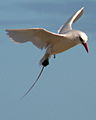
Red-tailed tropic bird


Individual evidence
- ↑ a b c d environment.gov.au : Lord Howe Island Marine Park (Commonwealth Waters), in English, accessed August 7, 2011
Coordinates: 31 ° 33 ′ 0 ″ S , 159 ° 6 ′ 0 ″ E