
Longuenée-en-Anjou
| Longuenée-en-Anjou | ||
|---|---|---|
|
||
| region | Pays de la Loire | |
| Department | Maine-et-Loire | |
| Arrondissement | Angers | |
| Canton |
Angers-4 , Tiercé |
|
| Community association | Angers Loire metropolis | |
| Coordinates | 47 ° 34 ′ N , 0 ° 40 ′ W | |
| height | 12-102 m | |
| surface | 53.5 km 2 | |
| Residents | 6,331 (January 1, 2017) | |
| Population density | 118 inhabitants / km 2 | |
| Post Code | 49770 | |
| INSEE code | 49200 | |
| Website | http://longuenee-en-anjou.fr/ | |
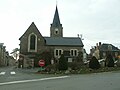
.JPG) Town hall (Mairie) of Longuenée-en-Anjou |
||

Longuenée-en-Anjou is a French commune with 6,331 inhabitants (as of January 1 2017) in the department of Maine-et-Loire in the region of Pays de la Loire . It belongs to the Arrondissement of Angers and the canton of Angers-4 (the village of Pruillé belongs to the canton of Tiercé ). The inhabitants are called Longuenéens .
Longuenée-en-Anjou was formed on January 1, 2016 as a commune nouvelle from the municipalities of La Membrolle-sur-Longuenée , La Meignanne , Le Plessis-Macé and Pruillé . The administrative headquarters are in la Membrolle-sur-Longuenée.
geography
Longuenée-en-Anjou is about eight kilometers northwest of the city center of Angers on the Mayenne . Longuenée-en-Anjou is surrounded by the neighboring communities of Grez-Neuville in the north, Sceaux-d'Anjou in the northeast, Feneu in the east and northeast, Montreuil-Juigné in the east, Avrillé in the southeast, Beaucouzé in the south, Saint-Lambert-la- Potherie in the south and south-west, Saint-Clément-de-la-Place in the west and Erdre-en-Anjou in the north-west.
structure
| District | former INSEE code |
Area (km²) | Population (2014) |
|---|---|---|---|
| La Meignanne | 49196 | 23.39 | 2,235 |
| La Membrolle-sur-Longuenée (administrative headquarters) | 49200 | 9.44 | 2,027 |
| Le Plessis-Macé | 49242 | 7.99 | 1,230 |
| Pruillé | 49251 | 12.68 | 719 |
Attractions
La Membrolle-sur-Longuenée
- Saint-Pierre church
- La Roussière watermill
- Forest of the Longuenée
La Meignanne
- Fessine dolmen
- Saint-Venant church from the 19th century
- Old rectory from 1738 (town hall since 2006)
- Saint-Quentin castle from the 19th century
- 19th century castle of Saint-Venant
- La Goujonnaie Castle from the 18th / 19th centuries century
- La Cailleterie castle from the 18th century
- La Filotière Castle
- Tower of the La Coudre mill
- La Tansolière and La Farauderie mills
Le Plessis-Macé
- Saint-Pierre church from 1472
- Le Plessis-Macé castle from the 12th century, alterations from the 14th century
Pruillé
- Saint-Symphorien Church

Center of La Membrolle with the Saint-Pierre church
Saint-Venant church in La Meignanne

Saint-Pierre church in Le Plessis-Macé

Le Plessis-Macé castle

St Symphorien Church in Pruillé
.JPG)


Community partnerships
A partnership has existed with the German municipality of Alfhausen in Lower Saxony since 2017 (since 1997 with the Le Meignanne district).
Web links
- Monuments historiques (objects) in Longuenée-en-Anjou in the base Palissy of the French Ministry of Culture
Individual evidence
- ↑ Population figures retrospectively as of January 1, 2014