Les Rairies
| Les Rairies | ||
|---|---|---|
|
|
||
| region | Pays de la Loire | |
| Department | Maine-et-Loire | |
| Arrondissement | Angers | |
| Canton | Tiercé | |
| Community association | Anjou Loir et Sarthe | |
| Coordinates | 47 ° 39 ′ N , 0 ° 12 ′ W | |
| height | 22-43 m | |
| surface | 8.41 km 2 | |
| Residents | 1,013 (January 1, 2017) | |
| Population density | 120 inhabitants / km 2 | |
| Post Code | 49430 | |
| INSEE code | 49257 | |
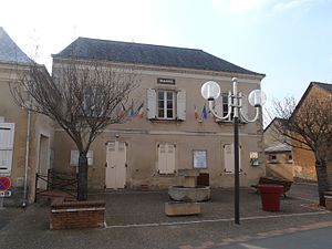
 Town hall (Mairie) of Les Rairies |
||
Les Rairies is a French commune with last 1,013 inhabitants (as of January 1 2017) in the department of Maine-et-Loire in the region of Pays de la Loire . It belonged to the Arrondissement of Angers and the canton of Tiercé (until 2015: Canton Durtal ). The inhabitants are called Rairieux .
geography
Les Rairies is located about 25 kilometers northeast of Angers in the Baugeois on the Loir , which forms the extreme northeastern municipal boundary. Les Rairies is surrounded by the neighboring communities of Durtal in the north and west, Bazouges-sur-le-Loir in the east and northeast, Fougere in the southeast and Montigné-lès-Rairies in the south.
Population development
| year | 1962 | 1968 | 1975 | 1982 | 1990 | 1999 | 2006 | 2017 |
| Residents | 810 | 781 | 764 | 802 | 854 | 866 | 956 | 1013 |
| Sources: Cassini and INSEE | ||||||||
Attractions
The Church of the Assumption (L'église de l'Ascension) from the 19th century is located in the center of the village.
In addition to the church, the local brick kiln, the Briqueterie Le Croc , is the most famous building in the village. The briqueterie was awarded a Monument historique in 1995 (see also: List of Monuments historiques in Les Rairies ).
literature
- Le Patrimoine des Communes de Maine-et-Loire . Flohic Editions, Volume 1, Paris 2001, ISBN 2-84234-117-1 , pp. 611-614.

