
Aubigné-sur-Layon
| Aubigné-sur-Layon | ||
|---|---|---|

|
|
|
| region | Pays de la Loire | |
| Department | Maine-et-Loire | |
| Arrondissement | Angers | |
| Canton | Chemillé-Melay | |
| Community association | Loire Layon Aubance | |
| Coordinates | 47 ° 13 ′ N , 0 ° 28 ′ W | |
| height | 36-80 m | |
| surface | 5.32 km 2 | |
| Residents | 366 (January 1, 2017) | |
| Population density | 69 inhabitants / km 2 | |
| Post Code | 49540 | |
| INSEE code | 49012 | |
| Website | http://www.aubignesurlayon.fr/ | |

Aubigné-sur-Layon is a French municipality with 366 inhabitants (as of January 1 2017) in the department of Maine-et-Loire in the region of Pays de la Loire . It belongs to the Angers and the canton of Chemillé-Melay (until 2015: canton of Vihiers ). The inhabitants are called Aubignois .
geography
Aubigné-sur-Layon is located about 26 kilometers south-southeast of Angers in the Anjou wine-growing region , especially in the Coteaux-du-Layon region . In the west the Layon limits the community. Aubigné-sur-Layon is surrounded by the neighboring communities Terranjou in the north and north-east, Lys-Haut-Layon in the east, Montilliers in the south and south-west and Faveraye-Mâchelles in the west and north-west.
Population development
| year | 1962 | 1968 | 1975 | 1982 | 1990 | 1999 | 2006 | 2017 |
| Residents | 356 | 324 | 271 | 257 | 263 | 334 | 361 | 366 |
| Sources: Cassini and INSEE | ||||||||
Attractions
See also: List of Monuments historiques in Aubigné-sur-Layon
- Saint-Denis church, historic monument since 1993
- Aubigné Castle, historic monument since 1930
Viticulture
The place belongs to the Anjou wine region .

Notre-Dame church
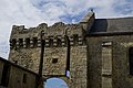
Portal of the Aubigné castle


literature
- Le Patrimoine des Communes de Maine-et-Loire . Flohic Editions, Volume 2, Paris 2001, ISBN 2-84234-117-1 , pp. 1315-1316.