
Soulaines-sur-Aubance
| Soulaines-sur-Aubance | ||
|---|---|---|
|
||
| region | Pays de la Loire | |
| Department | Maine-et-Loire | |
| Arrondissement | Angers | |
| Canton | Les Ponts-de-Cé | |
| Community association | Angers Loire metropolis | |
| Coordinates | 47 ° 22 ′ N , 0 ° 31 ′ W | |
| height | 17-96 m | |
| surface | 12.72 km 2 | |
| Residents | 1,423 (January 1, 2017) | |
| Population density | 112 inhabitants / km 2 | |
| Post Code | 49610 | |
| INSEE code | 49338 | |
| Website | http://www.soulaines-sur-aubance.fr/ | |

Soulaines-sur-Aubance is a French commune with 1,423 inhabitants (as of January 1 2017) in the department of Maine-et-Loire in the region of Pays de la Loire . The municipality belongs to the Arrondissement of Angers and the canton of Les Ponts-de-Cé . The inhabitants are called Soulainois .
geography
Soulaines-sur-Aubance is about ten kilometers south of Angers on the Aubance and belongs to the Anjou wine-growing region . Soulaines-sur-Aubance is surrounded by the neighboring communities of Mûrs-Erigné in the north and north-west, Saint-Melaine-sur-Aubance in the north and north-east, Brissac Loire Aubance in the east and south-east, Faye-d'Anjou in the south and Mozé-sur- Louet to the west.
Population development
| year | 1962 | 1968 | 1975 | 1982 | 1990 | 1999 | 2006 | 2013 |
|---|---|---|---|---|---|---|---|---|
| Residents | 390 | 402 | 506 | 694 | 1,032 | 1,189 | 1,193 | 1,232 |
|
Source: INSEE
|
||||||||
Attractions
See also: List of Monuments historiques in Soulaines-sur-Aubance
- Notre-Dame church
- La Morinière Castle, a historic monument since 1988
- Noizé Castle from 1775
- La Constatinière house, Monument historique since 1994
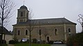
Notre-Dame church

Noizé Castle


Viticulture
The place belongs to the Anjou wine region .
Community partnerships
There is a partnership with the town of Rottmersleben in the German municipality of Hohe Börde in Saxony-Anhalt.
literature
- Le Patrimoine des Communes de Maine-et-Loire . Flohic Editions, Volume 2, Paris 2001, ISBN 2-84234-117-1 , pp. 1013-1014.