
Brissac Loire Aubance
| Brissac Loire Aubance | ||
|---|---|---|
|
||
| region | Pays de la Loire | |
| Department | Maine-et-Loire | |
| Arrondissement | Angers | |
| Canton | Les Ponts-de-Cé | |
| Community association | Loire Layon Aubance | |
| Coordinates | 47 ° 21 ′ N , 0 ° 27 ′ W | |
| height | 18-92 m | |
| surface | 120.89 km 2 | |
| Residents | 10,807 (January 1, 2017) | |
| Population density | 89 inhabitants / km 2 | |
| Post Code | 49250, 49320 | |
| INSEE code | 49050 | |
| Website | http://www.brissacloireaubance.fr/ | |

Brissac Loire Aubance is a French municipality with 10,807 inhabitants (as of January 1 2017) in the department of Maine-et-Loire in the region of Pays de la Loire . It belongs to the Arrondissement of Angers and the canton of Les Ponts-de-Cé (the villages of Chemellier and Coutures belong to the canton of Doué-la-Fontaine ).
Brissac Loire Aubance was established on December 15, 2016 as a commune nouvelle from the communes of Les Alleuds , Brissac-Quincé , Charcé-Saint-Ellier-sur-Aubance , Chemellier , Coutures , Luigné , Saint-Rémy-la-Varenne , Saint-Saturnin- sur-Loire , Saulgé-l'Hôpital and Vauchrétien . The administrative headquarters are in Brissac-Quincé.
geography
Brissac Loire Aubance is located about 18 kilometers southeast of the city center of Angers on the Loire . Brissac Loire Aubance is surrounded by the neighboring communities of Les Garennes-sur-Loire in the north and north-west, Loire-Authion and Blaison-Saint-Sulpice in the north, Gennes-Val-de-Loire in the east, Tuffalun in the southeast, Doué-en-Anjou to the south, Terranjou to the south and south-west, Bellevigne-en-Layon to the west and south-west and Soulaines-sur-Aubance and Saint-Melaine-sur-Aubance to the north-west.
structure
| District | former INSEE code |
Area (km²) | Population (2017) |
|---|---|---|---|
| Les Alleuds | 49001 | 10.47 | 904 |
| Brissac-Quincé (administrative headquarters) | 49050 | 9.76 | 3,095 |
| Charcé-Saint-Ellier-sur-Aubance | 49078 | 16.84 | 787 |
| Chemellier | 49091 | 10.99 | 795 |
| Coutures | 49115 | 9.31 | 520 |
| Luigné | 49186 | 9.58 | 265 |
| Saint-Rémy-la-Varenne | 49317 | 15.67 | 971 |
| Saint-Saturnin-sur-Loire | 49318 | 11.94 | 1,359 |
| Saulgé-l'Hôpital | 49327 | 6.60 | 620 |
| Vauchrétien | 49363 | 19.73 | 1,491 |
Attractions
Brissac quincé
- Saint-Vincent church, 19th century, with 16th century window; belonging to the parish of Saint-Vincent-en-Aubance
- Brissac Castle with park
Les Alleuds
- Saint-Aubin church
- Saint-Aubin Priory, Monument historique
Charcé-Saint-Ellier-sur-Aubance
- Charcé dolmen and stone circle ( cromlech ), monument historique since 1889
- Saint-Pierre church in Charcé, monument historique since 2001
- Patouillet windmill, Monument historique since 1977
- La Bluttière house, historic monument since 2006
Coutures
- Dolmen of L'Etiau and dolmen of Montsabert
- Saint-Pierre church, historique monument since 1975
- Montsabert Castle from the 14th century, monument historique since 1986
Luigné
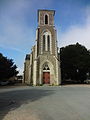
- Saint-Avertin church from the 19th century
- Commander of Saulge
- Luigné Castle from the beginning of the 16th century
Saint-Rémy-la-Varenne
- Saint-Rémy church
Saint-Saturnin-sur-Loire
- Saint-Saturnin Church
- La Fosse mansion from the 17th century
- La Groye mansion from the 16th / 17th centuries century
- Big mill
- Denneron Mill from the 17th century
- Les Giraults mill from the 18th century
- Mill of Les Quatre Croix from the 18th / 19th century century
Saulgé-l'Hôpital
- Saint-Maxenceul church
Vauchrétien
- Rectory from the 15th century
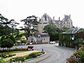
Brissac Castle
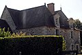
Saint-Aubin church in Les Alleuds
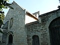
Priory of Les Alleuds

Charcé dolmen

Saint-Pierre church in Charcé

Patouillet windmill

House La Bluttière

Dolmen of L'Etiau

Montsabert Castle

Saint-Avertin church in Luigné

Saint-Remy church in Saint-Rémy-la-Varenne
Saint-Saturnin church in Saint-Saturnin-sur-Loire
La Fosse manor house

La Groye mansion

Large mill in Saint-Saturnin-sur-Loire

Les Quatre Croix windmill

Saint-Maxenceul church in Saulgé-l'Hôpital


._(26957596576).jpg)


Web links
- Monuments historiques (objects) in Brissac Loire Aubance in the base Palissy of the French Ministry of Culture
- Monuments historiques (structures) in Brissac Loire Aubance in the Base Mérimée of the French Ministry of Culture
Individual evidence
- ↑ current population according to INSEE