
Marcé
| Marcé | ||
|---|---|---|
|
||
| region | Pays de la Loire | |
| Department | Maine-et-Loire | |
| Arrondissement | Angers | |
| Canton | Angers-6 | |
| Community association | Anjou Loir et Sarthe | |
| Coordinates | 47 ° 35 ′ N , 0 ° 20 ′ W | |
| height | 32-97 m | |
| surface | 21.09 km 2 | |
| Residents | 841 (January 1, 2017) | |
| Population density | 40 inhabitants / km 2 | |
| Post Code | 49140 | |
| INSEE code | 49188 | |

Marcé is a French commune with the last 841 inhabitants (as of January 1 2017) in the department of Maine-et-Loire in the region of Pays de la Loire . It belonged to the Arrondissement of Angers and the Canton of Angers-6 (until 2015: Canton Seiches-sur-le-Loir ). The inhabitants are called Marcéens .
geography
Marcé is about 24 kilometers northeast of Angers in the Baugeois . Marcé is surrounded by the neighboring communities of La Chapelle-Saint-Laud in the north, Durtal in the northeast, Jarzé Villages in the south and east, Corzé in the southwest and Seiches-sur-le-Loir in the west.
Angers Loire Airport is located in the southern municipal area . The A11 car route runs through the municipality .
Population development
| year | 1962 | 1968 | 1975 | 1982 | 1990 | 1999 | 2006 | 2013 |
| Residents | 582 | 547 | 526 | 593 | 619 | 637 | 805 | 844 |
| Source: Cassini and INSEE | ||||||||
Attractions
See also: List of Monuments historiques in Marcé
- Saint-Martin-de-Tours church from the 12th century, alterations in the 16th century, Monument historique
- Saint-Léonard chapel
- 18th century rectory
- La Brideraie mansion from the 16th century, Monument historique
- Le Bois-de-l'Humeau mansion from the 18th century, Monument historique
- Princé castle and chapel from the 16th century
- 19th century La Souchardière castle
- Remains of the Singé manor

Saint-Martin-de-Tours church
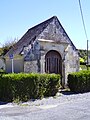
Saint-Léonard chapel

Manor house Le Bois-de-l'Humeau

La Brideraie mansion


literature
- Le Patrimoine des Communes de Maine-et-Loire . Flohic Editions, Volume 2, Paris 2001, ISBN 2-84234-117-1 , pp. 1246-1247.