
Soulaire-et-Bourg
| Soulaire-et-Bourg | ||
|---|---|---|
|
||
| region | Pays de la Loire | |
| Department | Maine-et-Loire | |
| Arrondissement | Angers | |
| Canton | Angers-5 | |
| Community association | Angers Loire metropolis | |
| Coordinates | 47 ° 35 ′ N , 0 ° 33 ′ W | |
| height | 14-59 m | |
| surface | 18.08 km 2 | |
| Residents | 1,495 (January 1, 2017) | |
| Population density | 83 inhabitants / km 2 | |
| Post Code | 49460 | |
| INSEE code | 49339 | |

Soulaire-et-Bourg is a French commune with 1,495 inhabitants (as of January 1 2017) in the department of Maine-et-Loire in the region of Pays de la Loire . It belongs to the Arrondissement of Angers and the Canton of Angers-5 (until 2015: Canton Tiercé ). The inhabitants are called Soleirébourgiens .
geography
Soulaire-et-Bourg is in the Anjou countryside . The river Sarthe limits the community in the extreme southeast. Neighboring communities of Soulaire-et-Bourg are Écuillé in the north, Cheffes in the northeast, Briollay in the east, Écouflant in the south and southeast, Cantenay-Épinard in the south and Feneu in the west.
Population development
| year | 1962 | 1968 | 1975 | 1982 | 1990 | 1999 | 2006 | 2013 |
| Residents | 744 | 746 | 792 | 1,046 | 1,063 | 1,189 | 1,346 | 1,461 |
| Source: Cassini and INSEE | ||||||||
Attractions
See also: List of the Monuments historiques in Soulaire-et-Bourg
- Saint-Martin church in Soulaire, monument historique since 1972
- Saint-Martin-de-Vertou church in Bourg, monument historique since 1972
- Le Bois Castle, Monument historique since 1972
- La Rousselière Castle, Monument historique since 1974
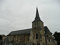
Saint Martin Church of Soulaire

Saint-Martin-de-Vertou church in Bourg

Le Bois Castle

La Rousselière Castle


literature
- Le Patrimoine des Communes de Maine-et-Loire . Flohic Editions, Volume 2, Paris 2001, ISBN 2-84234-117-1 , pp. 1310-1311.