
Corzé
| Corzé | ||
|---|---|---|

|
|
|
| region | Pays de la Loire | |
| Department | Maine-et-Loire | |
| Arrondissement | Angers | |
| Canton | Angers-6 | |
| Community association | Anjou Loir et Sarthe | |
| Coordinates | 47 ° 34 ′ N , 0 ° 23 ′ W | |
| height | 15-68 m | |
| surface | 31.49 km 2 | |
| Residents | 1,841 (January 1, 2017) | |
| Population density | 58 inhabitants / km 2 | |
| Post Code | 49140 | |
| INSEE code | 49110 | |
| Website | http://www.corze.fr/ | |

Corzé is a French commune with 1,841 inhabitants (as of January 1 2017) in the department of Maine-et-Loire in the region of Pays de la Loire . It belongs to the Arrondissement of Angers and the Canton of Angers-6 (until 2015: Canton Seiches-sur-le-Loir ). The inhabitants are called Corzéens .
geography
Corzé is located about 15 kilometers northeast of Angers in the Anjou region on the Loir , which forms the northwestern municipal boundary. Neighboring municipalities of Corzé are
- Montreuil-sur-Loir in the north and north-west,
- Seiches-sur-le-Loir in the north and northeast,
- Marcé in the northeast,
- Jarzé Villages in the east,
- Loire-Authion and Sarrigné in the south,
- Rives-du-Loir-en-Anjou with Villevêque in the west and Soucelles in the northwest.
The motorway triangle of the Autoroute A11 with the Autoroute A85 is located in the municipality .
Population development
| year | 1962 | 1968 | 1975 | 1982 | 1990 | 1999 | 2006 | 2013 |
| Residents | 1,209 | 1,158 | 1,252 | 1,265 | 1,365 | 1,520 | 1,581 | 1,718 |
| Source: Cassini and INSEE | ||||||||
Attractions
See also: List of the Monuments historiques in Corzé
- Dolmen du Bois de la Pidoucière , Monument historique since 1984
- 11th century Saint Germain church
- Remains of the Cistercian monastery Chaloché from 1129, since 1973 Monument historique
- Castle ruins of Ardannes from the 14th century

Dolmen
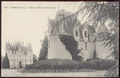
Remains of the Ardannes Castle


literature
- Le Patrimoine des Communes de Maine-et-Loire . Flohic Editions, Volume 2, Paris 2001, ISBN 2-84234-117-1 , p. 1238.
Web links
Commons : Corzé - collection of images, videos and audio files