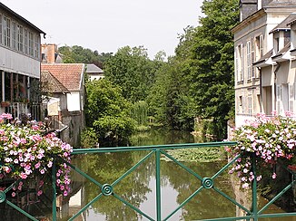
Loir
| Loir | ||
|
The Loir in Vendôme |
||
| Data | ||
| Water code | FR : M1-0160 | |
| location | France , Center-Val de Loire and Pays de la Loire regions | |
| River system | Loire | |
| Drain over | Sarthe → Maine → Loire → Atlantic Ocean | |
| source | in the Perche , municipality of Champrond-en-Gâtine 48 ° 22 ′ 41 ″ N , 1 ° 3 ′ 8 ″ E |
|
| Source height | approx. 265 m | |
| muzzle | at Briollay in the Sarthe coordinates: 47 ° 33 '28 " N , 0 ° 31' 35" W 47 ° 33 '28 " N , 0 ° 31' 35" W. |
|
| Mouth height | approx. 16 m | |
| Height difference | approx. 249 m | |
| Bottom slope | approx. 0.78 ‰ | |
| length | 319 km | |
| Small towns | Châteaudun , Vendôme , Château-du-Loir , La Flèche | |
The Loir (not to be confused with the Loire ) is a river in western France that runs through the Center-Val de Loire and Pays de la Loire regions. It rises in the Perche landscape , in the municipality of Champrond-en-Gâtine , drains in the upper reaches to the east and south-east, but then turns in the general direction south-west and flows into the Sarthe after 319 kilometers at Briollay , north of Angers , as a left tributary .
The wine-growing regions Coteaux du Loir , Jasnières and Coteaux du Vendômois lie along its banks .
Crossed departments
- Eure-et-Loir (28)
- Loir-et-Cher (41)
- Sarthe (72)
- Maine-et-Loire (49)
Tributaries
|
Left tributaries: |
Right tributaries: |
Places on the river
- Illiers-Combray
- Bonneval
- Châteaudun
- Cloyes-sur-le-Loir
- Vendôme
- Montoire-sur-le-Loir
- Château-du-Loir
- Le Lude
- La Flèche
- Durtal
- Seiches-sur-le-Loir
- Soucelles
- Villevêque
- Briollay
Web links
Commons : Loir - collection of images, videos and audio files
