
Maine (Loire)
| Maine | ||
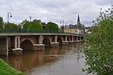
 The Maine at Angers |
||
| Data | ||
| Water code | FR : M4-0190 | |
| location | France , Pays de la Loire region | |
| River system | Loire | |
| Drain over | Loire → Atlantic Ocean | |
| origin | Confluence of the Sarthe and Mayenne rivers 47 ° 29 ′ 35 ″ N , 0 ° 32 ′ 32 ″ W |
|
| Source height | approx. 15 m | |
| muzzle | at Bouchemaine in the Loire Coordinates: 47 ° 24 ′ 39 ″ N , 0 ° 36 ′ 54 ″ W 47 ° 24 ′ 39 ″ N , 0 ° 36 ′ 54 ″ W. |
|
| Mouth height | approx. 13 m | |
| Height difference | approx. 2 m | |
| Bottom slope | approx. 0.17 ‰ | |
| length | 12 km | |
| Catchment area | 22,350 km² | |
| Outflow at the Angers gauge |
MQ |
130 m³ / s |
| Flowing lakes | Lac de Maine | |
| Big cities | Angers | |
| Navigable | Yes | |

The Maine [ mɛn ] is a river in western France that runs in the Maine-et-Loire department in the Pays de la Loire region . It arises near the town of Angers from the two rivers Sarthe and Mayenne on the southern tip of the island of Saint-Aubin, runs in a south-westerly direction and flows into the Loire after 12 km at Bouchemaine as a right tributary .
Maine is a derivative of Maienne and means river in the middle . Today's two rivers used to have a single Latin name: Mediuna . In usage, however, a separate name developed for the common mouthpiece used by Sarthe and Mayenne.
The name of the Maine-et-Loire department refers to the river. Maine is also the name of a former French province .
Pictures by Sarthe and Mayenne
Bridge in La Suze-sur-Sarthe
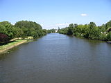
The Sarthe near Morannes (or Morannes-sur-Sarthe in the Arrondissement of Angers )
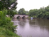
The Mayenne at Houssay ( Arrondissement Château-Gontier )
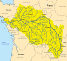
The Loire and its tributaries
.JPG)


On the map of the Loire river system ("The Loire and its tributaries") Sarthe and Mayenne are entered, but there was no space for the short Maine.
Web links
Individual evidence
- ↑ a b geoportail.fr (1: 16,000)
- ↑ a b c The information on the length of the river is based on the information about the Maine from SANDRE (French), accessed on November 26, 2011, rounded to the nearest kilometer.
- ↑ hydro.eaufrance.fr (station: M4101910 , option: Synthèse )