Arrondissement of Château-Gontier
| Arrondissement of Château-Gontier | |
|---|---|
| region | Pays de la Loire |
| Department | Mayenne |
| Sub-prefecture | Château-Gontier |
| Residents | 73,615 (Jan. 1, 2017) |
| Population density | 48 inhabitants / km² |
| surface | 1,527.39 km² |
| Cantons | 4th |
| Communities | 76 |
| INSEE code | 531 |
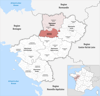
 Location of the arrondissement of Château-Gontier in the Mayenne department |
|
The District of Château-Gontier is an administrative unit in the French department of Mayenne in the region Pays de la Loire . The administrative seat ( sub-prefecture ) is Château-Gontier .
It consists of four cantons and 76 municipalities.
Cantons
- Azé
- Château-Gontier
- Cossé-le-Vivien
- Meslay-du-Maine (with 23 of 35 parishes)
Communities
The communes of the arrondissement of Château-Gontier are:
| 1. Arquenay (53009) | 2. Astillé (53011) | 3. Athée (53012) | 4. Ballots (53018) |
| 5. Bannes (53019) | 6. Bazougers (53025) | 7. Beaumont-Pied-de-Bœuf (53027) | 8. Bierné-les-Villages (53029) |
| 9. Bouchamps-lès-Craon (53035) | 10. Bouère (53036) | 11. Bouessay (53037) | 12. Brains-sur-les-Marches (53041) |
| 13. Château-Gontier-sur-Mayenne (53062) | 14. Châtelain (53063) | 15. Chemazé (53066) | 16. Chémeré-le-Roi (53067) |
| 17. Chérancé (53068) | 18th Congrier (53073) | 19. Cosmes (53075) | 20. Cossé-en-Champagne (53076) |
| 21. Cossé-le-Vivien (53077) | 22. Coudray (53078) | 23. Courbeveille (53082) | 24. Craon (53084) |
| 25th Cuillé (53088) | 26. Daon (53089) | 27. Denazé (53090) | 28. Fontaine envelope (53098) |
| 29. Fromentières (53101) | 30. Gastines (53102) | 31. Gennes-Longuefuye (53104) | 32. Grez-en-Bouère (53110) |
| 33. Houssay (53117) | 34. La Bazouge-de-Chemeré (53022) | 35. La Boissière (53033) | 36. La Chapelle-Craonnaise (53058) |
| 37. La Cropte (53087) | 38. La Roche-Neuville (53136) | 39. La Roë (53191) | 40. La Rouaudière (53192) |
| 41. La Selle-Craonnaise (53258) | 42. Laubrières (53128) | 43. Le Bignon-du-Maine (53030) | 44. Le Buret (53046) |
| 45. Livré-la-Touche (53135) | 46. Maisoncelles-du-Maine (53143) | 47. Marigné-Peuton (53145) | 48th Mée (53148) |
| 49. Ménil (53150) | 50. Méral (53151) | 51. Meslay-du-Maine (53152) | 52. Niafles (53165) |
| 53. Origné (53172) | 54. Peuton (53178) | 55. Pommerieux (53180) | 56. Préaux (53184) |
| 57. Prée-d'Anjou (53124) | 58. Quelaines-Saint-Gault (53186) | 59. Renazé (53188) | 60th Ruillé Froid Fund (53193) |
| 61. Saint-Aignan-sur-Roë (53197) | 62. Saint-Brice (53203) | 63. Saint-Charles-la-Forêt (53206) | 64. Saint-Denis-d'Anjou (53210) |
| 65.Saint -Denis-du-Maine (53212) | 66. Saint-Erblon (53214) | 67. Saint-Loup-du-Dorat (53233) | 68. Saint-Martin-du-Limet (53240) |
| 69. Saint-Michel-de-la-Roë (53242) | 70. Saint-Poix (53250) | 71. Saint-Quentin-les-Anges (53251) | 72. Saint-Saturnin-du-Limet (53253) |
| 73 Senonnes (53259) | 74. Simplé (53260) | 75. Val-du-Maine (53017) | 76. Villiers-Charlemagne (53273) |
Reorganization of the arrondissements in 2017
As a result of the reorganization of the arrondissements in 2017, the Arrondissement Laval became the area of the 14 municipalities of Arquenay , Astillé , Bannes , Bazougers , Chémeré-le-Roi , Cossé-en-Champagne , Courbeveille , La Bazouge-de-Chemeré , La Cropte , Le Bignon-du-Maine , Maisoncelles-du-Maine , Meslay-du-Maine , Saint-Denis-du-Maine and Val-du-Maine are assigned to the arrondissement of Château-Gontier.
Former parishes since the nationwide reorganization of the arrondissements
until 2018: Bierné , Argenton-Notre-Dame , Saint-Laurent-des-Mortiers , Saint-Michel-de-Feins , Château-Gontier , Azé , Saint-Fort , Gennes-sur-Glaize , Longuefuye , Loigné-sur-Mayenne , Saint-Sulpice
until 2016: Ballée , Épineux-le-Seguin
